
Early Images of Gaithersburg and Surrounding Area

Early 1900s aerial view of Braddock Heights. Photo by Lewis Reed.
Old photos have an amazing way of showing us what life was like years ago and depicting how our communities once looked. You might not realize how much things have changed until you look back and see what it looked like in the past. Lewis Reed grew up in Darnestown and later lived in Gaithersburg, so many of his photographs depict that specific region of Montgomery County. Take a journey back in time through the lens of Lewis Reed and see what Gaithersburg and the surrounding area looked like more than one hundred years ago. As always, click the photos to get a better look.
Philip Reed Blacksmith Shop and Farmhouse in Darnestown, early 1900s

Philip Reed farmhouse and blacksmith shop located on Darnestown Road near the intersection of Seneca Road. Photo by Lewis Reed, early 1900.
Philip Reed (1845-1918), father of Lewis Reed, was an early settler in Darnestown and operated a blacksmith, wheelwright, and cabinet making business next to his home. Darnestown residents of that time included a doctor, a merchant, a blacksmith and a wheelwright. As late as 1910, there were still approximately 60 blacksmith shops in the county.
Hunting Hill, 1903

Buggies traversed rutted dirt roads across the Montgomery County countryside — sometimes their occupants needed a rest in the shade from the jolting motion of the carriage and the pounding heat of the sun. The photo above was taken by Lewis Reed on Hunting Hill Road ca. 1903.
The area along Darnestown Road between Travilah and Muddy Branch Roads was once a small rural community known as Hunting Hill. The village included a blacksmith shop, two general stores, and a schoolhouse. This photograph of Darnestown Road looking west shows the Magruder house at the corner of Travilah Road.
General Store at Quince Orchard, 1906

General Store at Quince Orchard. Photo by Lewis Reed, 1906
A small school for white children was established on the northeast corner of Darnestown and Quince Orchard Roads around 1850. It was damaged during the Civil War and eventually burned down in 1873. The school was rebuilt on the same site in 1875 but was moved across the road next to Pleasant View Methodist Church in 1902 after the fire destroyed the school for black children. The General Store at Quince Orchard was built on the same site shortly after the school building was moved.
Barnesville B&O Train Station, 1912

Barnesville B&O Train Station, 1912. Photo by Lewis Reed.
The original station building was torn down in the late 1950s, and for many years there was no shelter at this popular up-county stop. It was finally decided to move to the site a 16-by-22-foot historic metering station owned by the Washington Gas Light Company, with the gas company, the county, and the city and residents of Barnesville sharing the costs. The squarish little structure had a makeover after the move. It was painted inside and out and a wide overhanging roof was added just below the original roof line, giving the building more an authentic “train station” look, and it was re-dedicated on October 10, 1977. Snuggled up against the woods, surrounded by trees and shrubbery in a rural area just south of Barnesville on Route 109 (Beallsville Road), the station today is a pretty sight.
Martin Thompson House, 1907

Route 28, Darnestown Road Circa 1907 – Martin Thompson House, owned by Lewis Reed’s maternal grandfather. Photo by Lewis Reed.
The home in the photo was owned by James Martin Thompson (1825–1902), Lewis Reed’s maternal grandfather. It was then called “Pleasant Hills”, which was located just opposite of the Thomas Kelly farm. In the early days, it was common practice for a family to give a name to their property. The house was accessed from Darnestown Road by a long tree-lined drive.
Route 28, in Darnestown is depicted in this photo before paving. What is now Route 28 is one of the earliest roads in the county, and was one of the main ways farmers in Poolesville, Darnestown, Dickerson, and Barnesville reached the courthouse in Rockville. Darnestown Road has existed since before the Civil war, and it remained a mud path for years into the automobile age.
Most houses in the Darnestown “Pleasant Hills” area were not very large and most were made of wood rather than brick. According to the 1860 Federal Census, Martin Thompson’s occupations were listed as Carpenter and Farmer living in Darnestown, Montgomery County, Maryland.
This photograph won an honorable mention in a contest sponsored by Rotary International for Lewis Reed.
Germantown Road at Seneca Creek, 1907

Germantown Road at Seneca Creek looking West. Photo by Lewis Reed, 1907

Germantown Road at Seneca Creek. Photo by Lewis Reed, 1907.
This view of Route 118 looking west shows the old one-lane stone bridge over the creek. In the 1930s, many of these old bridges were replaced with concrete bridges, and concrete roads were installed. Today, the rolling hills are covered with trees, and hikers can enjoy the Seneca Creek Ridge Trails, which runs directly through the land in this photograph.
Diamond Avenue in Gaithersburg, 1911

Left to Right: Belt’s Store, (sign) Charlie Foo’s Laundry, Nicholl’s Harness Shop, Etchison’s Drug Store (now Diamond Drugs), First National Bank of Gaithersburg, Jacob Miller’s Livery Stable. Photo by Lewis Reed, 1911
After the arrival of the Baltimore and Ohio Railroad in 1873, Gaithersburg’s business district had diversified to include John Belt’s mercantile store, reportedly the largest general store in the county. Many of the business owners probably lived above their shops. When constructed in 1903, the Belt building was the most ornate and substantial commercial structure in Gaithersburg.
Etchison’s Drug Store was one of the two first commercial buildings that sprang up near the business center of Gaithersburg. Earlier, two upstairs rooms of the drug store had been occupied as the dental office of Bates Etchison, DDS. Dr. Etchison would on occasion throw extracted teeth out his window, to the curious amazement of young boys below.
The second of the two nineteenth century commercial buildings was the Nicholl’s Harness shop. Nicholls Harness Shop claimed to have the best selection of harnesses and related merchandise in the state. Charlie Foo, a Chinese immigrant, owned and operated a laundry shop. The First National Bank of Gaithersburg opened on the northeast corner of Diamond and Summit Avenues in 1891.
Gaithersburg B&O Train Station, 1911

Baltimore & Ohio Railroad Station in Gaithersburg. Photo by Lewis Reed, 1911.
The station was originally built as the Gaithersburg B&O Railroad Station and Freight Shed in 1884, for the Metropolitan Branch of te Baltimore and Ohio Railroad (B&O). A freight house, which currently houses the Gaithersburg Community Museum, allowed farmers to easily ship their products. Over the years, the station buildings gradually fell into disrepair and by the 1960’s were slated for demolition. According to the Gaithersburg city website, they were purchased by the city from the Chessie Systems in 1984 and restored. The Station and Freight House have been listed in the National Register of Historical Places since 1978.
Montgomery County Almshouse, 1912

Montgomery County Almshouse. Photo by Lewis Reed, 1912
Before nursing homes, there were almshouses. The Montgomery County Almshouse was built in 1789 to provide for the County’s Indigent. The Almshouse never housed a large number of people. Over the years, the maximum number of residents appeared to range between 20 and 30. Occasionally, the Almshouse sheltered migrants, hitchhikers, or others in need of short-term temporary quarters. The 50-acre tract also included a pauper’s graveyard. As the 19th century began to unwind, women and church groups began founding Homes for the Aged.
Clarksburg Main Street, 1913

Main street (Frederick Road Rt 355) Clarksburg, 1913. Photo by Lewis Reed
By the early 20th Century, Clarksburg was the third largest town in Montgomery County after Rockville and Poolesville. Clarksburg had four general stores, two hotels, and an academy of learning. It also had a blacksmith, a doctor’s office, tanneries, shoemakers, winemakers, tailors, wheelwrights, fertilizer businesses, skilled farmers, master carpenters and two town bands.
Thomas & Company Cannery, 1917

Circa 1917 photo taken behind the Thomas and Company Cannery in Gaithersburg. The Cannery was the first and largest vegetable cannery in Montgomery County. It closed in 1963 after fire damage and lay empty until its recent restoration. Photo by Lewis Reed.
The largest and longest-lived cannery in Montgomery County, the Thomas and Company Cannery operated from 1917 until 1962. While Baltimore had been the center of the canning industry in the 19th century, the outbreak of World War I created a need to rationalize. Frank and Clyde Thomas were leaders in the 20th century canning industry in Maryland. In 1917, the Thomas family opened a cannery in Gaithersburg, the first in Montgomery County. The factory was the focus of local industry and economy, providing an important market for farmers, and employment for local migrant workers.
The factory canned peas, pumpkin and corn, supplied both the local retail market and the war effort during WW I and II. During the war years, the cannery expanded operations and functioned on a three shift schedule to provide vegetables for shipment to troops. After the war, the cannery continued to produce vegetables under the brand names MY-T-NICE, EVER-GOOD, BARBARA FRITCHIE and ON-TOP corn, peas and succotash.
Built along the B & O Railroad to facilitate shipping, the brick cannery had three main parts: the central processing station, the shipping section and boiler plant. The cannery was designated a Gaithersburg landmark in 1987.
Walker Avenue in Gaithersburg, late 1920s

Walker Avenue in Gaithersburg taken from the steeple of Grace United Methodist Church, late 1920s. Photo by Lewis Reed
This photo of Walker Avenue in Gaithersburg was taken by Lewis Reed from the steeple of Grace United Methodist Church in the late 1920s. The street is named after John Walker, whose farm became Walker Avenue when he decided to subdivide the front end in 1904. Walker was mayor of Gaithersburg from 1906 to 1908 and again from 1918 to 1924. In June 1913, Walker Avenue was the first street in Gaithersburg to have electric streetlights installed along its full length. This period saw major advances in technology, communication, and transportation. Most of its houses were built between 1904 and 1930.
Thomas Hardware Store, 1928

Thomas Hardware Store, originally built and operated by Thomas I. Fulks. Photo by Lewis Reed, 1928
The above photo was taken by Lewis Reed when the first system of water mains and sewers were installed by the WSSC in Gaithersburg, circa 1926-1928. The store in the background is the Thomas Hardware Store, originally built and operated by Thomas Iraneous Fulks. The water pipes to be laid are resting by the side of the road. The child on the right in the photograph is Lewis Reed’s daughter, Mary Jane (Reed) Gartner. T. I. Fulks was a businessman and farmer. He worked as a bookkeeper for the Gaithersburg Milling and Manufacturing Company and then opened a hardware store at 219 East Diamond Avenue.
Asbury Methodist Village, late 1920s

“Methodist Home for the Aged”. Photo by Lewis Reed, ca. late 1920s
Asbury Methodist Home for the Aged, predecessor of the Village, was established in Montgomery County almost 100 years ago. When care for the elders of the community failed, aged citizens with no funds were designated paupers and sent to the Montgomery County Almshouse on Seven Locks Road in Rockville.
Built in 1926 on the 106-acre dairy farm of William Magruder, called Rolling Acres, Asbury Methodist Home for the Aged opened its doors for residents on April 15, 1926, and the first five elderly residents moved in. The community changed its name to Asbury Methodist Village in 1969. Today, Asbury Methodist Village is the largest continuing care retirement community in Montgomery County, Maryland, and the 14th largest in the United States.
Montgomery County F3 Tornado (Aftermath) May 2, 1929
At about 9 p.m. on Thursday, May 2, 1929, northeastern Montgomery County was struck by an F3 tornado, part of a large storm system that caused devastation from Florida to Ohio. The weekly Montgomery County Sentinel reported on May 10th that the “wind storm of cyclonic power . . . was of limited width and serpentine on its course. Everything in its path met with destruction.” These photographs were taken by Lewis Reed “after the tornado of May 2, 1929”.
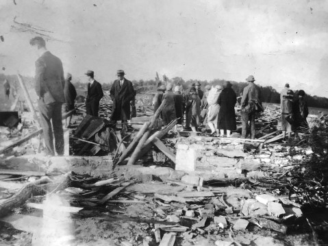
Spectators view the destruction at the Benson farm, May 1929. Photo by Lewis Reed
The damage in the county was limited to the rural Unity area, north of Brookeville. The Sentinel article detailed each affected farm, noting that “thousands of persons from far and near visited the scene for several days to look upon the indescribable wreckage.”

May 1929. Photo by Lewis Reed
From the Sentinel: “The storm showed its first violence upon the farm of Mr. J. William Benson. There it destroyed every building – the dwelling house, large barn, 117 feet long, including an attached shed, and all other outbuildings.” The farm was unoccupied, but furniture belonging to “a prospective tenant” was destroyed. Mr. Benson’s apple orchard was also significantly damaged, and the article claimed that “many [trees] were lifted into the air, carried over woods and landed several miles away.”
The fire departments of Rockville, Gaithersburg and Sandy Spring responded to the call made by farm worker James Leizear, who “extricated himself from the wreckage” and ran half a mile to a neighbor’s house to summon help.
The Post reported on May 4th that 28 people in Maryland and Virginia had been killed by tornadoes during the storm; most of the casualties were in Virginia, where an elementary school was struck full-force and at least 18 children died. In Montgomery County, the local Red Cross Chapter formed a citizen committee to raise funds “for relief of the sufferers.”
Books
![]()
Related Resources


Copyright Notice

Reed Brothers Dodge History (1915-2012) by Jeanne Gartner is licensed under a Creative Commons Attribution-NonCommercial 3.0 Unported License.

Recent Comments