
Aerial Views
Lewis Reed was not an aviator, but he obviously saw great potential in taking photographs from the air. The black and white aerial photographs below of Reed Brothers Dodge at its original location were taken by Lewis Reed from a Goodyear Blimp that came to the dealership in 1938 to promote tires. The images are some of the earliest known aerial photographs taken of Rockville. (click on photos to enlarge)
From The Montgomery County Sentinel, April 21, 1938:
“Goodyear Blimp To Visit Rockville On April 28”
Local residents who have wondered how an airship is moored for the night when remaining away from its dock will have an opportunity to see for themselves just how this is accomplished, it was announced today by Reed Brothers, local dealer for The Goodyear Tire and Rubber Co.
Reed Brothers, who are sponsoring the visit to Rockville April 28th of the Goodyear Life Guard demonstration and the Goodyear airship Enterprise, has just been informed that this city has been selected as one in which the airship will spend a night on the mooring mast.
One of those things that have to be seen to be believed, the blowout of a tire on a car traveling at upward of 60 miles an hour without serious consequences of any kind, is to be shown in Rockville on April 28. This demonstration will be staged at 1:30 P.M. in this city. Local police authorities have consented to the demonstration and will assist in conducting it.
Aerial view of entire original Reed Brothers dealership at the intersection of Veirs Mill Road and Rockville Pike. A two-story house stands behind the dealership. Photo by Lewis Reed.

Later aerial view showing the used car lot where previously stood a two-story house. St Mary’s Church at lower portion of photo. The connector street behind the dealership was later named “Dodge Street” commemorating Reed Brothers’ presence from 1915-1970. Photo by Lewis Reed.

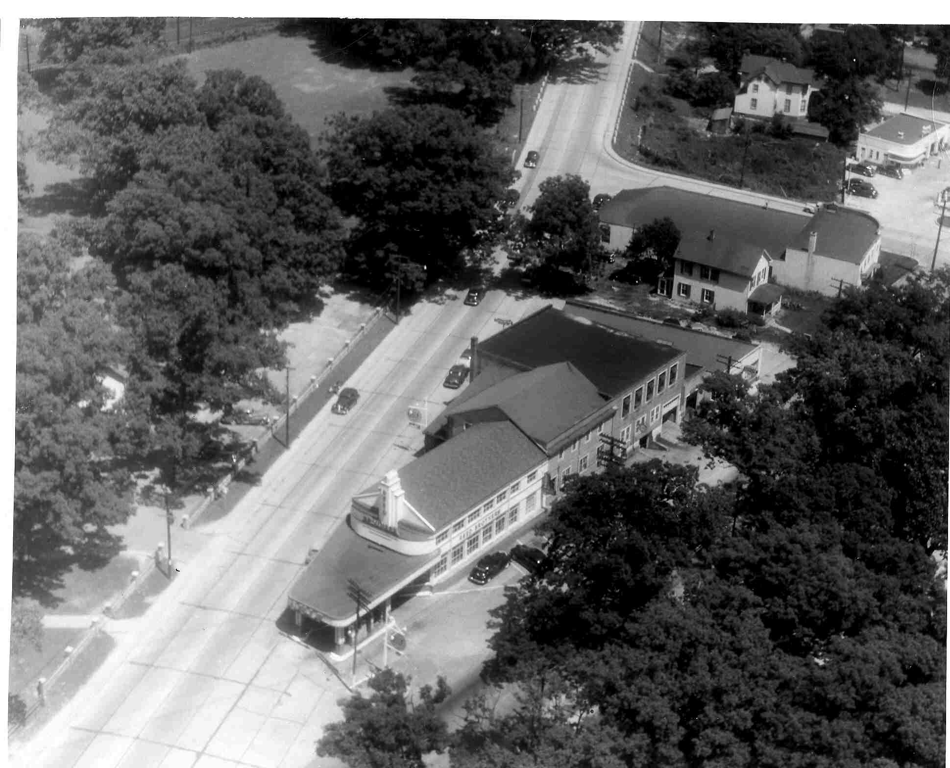
Original Reed Brothers facility in the triangle at the intersection of Veirs Mill Road and Rockville Pike. Note the unpaved dirt road. The bridge, often referred to as “Pigeon Bridge” crosses the Baltimore & Ohio Railroad (now CSX). Notice the cars parked sideways on Veirs Mill Road … imagine that now! Photo by Lewis Reed.

Original Reed Brothers facility with St Mary’s Church and Cemetery at upper portion of photo. The road at the bottom is Rockville Pike which then turned to the left to become old East Montgomery Ave. The next road in the picture going back is Veirs Mill Road just before it merges into Rockville Pike, and the road in the back is Baltimore Road which crossed the tracks until 1935. Photo by Lewis Reed.
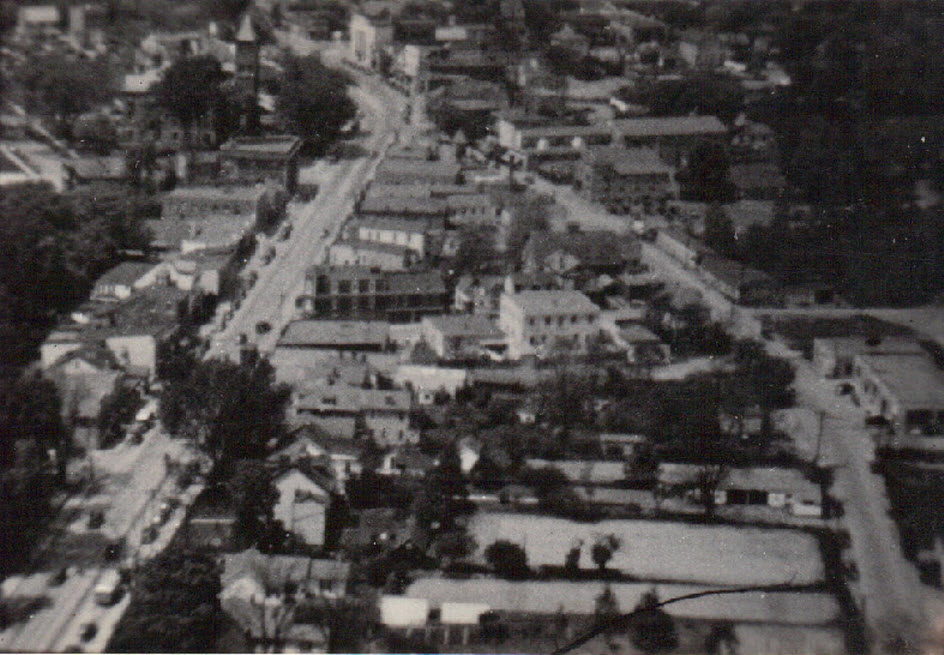
An aerial view looking over Rockville. The Red Brick Courthouse tower can be seen top left. East Montgomery Ave. is on the left and Commerce Lane to the right. At 12 o’clock is the bank building which still stands today across from the old Post Office, now the Rockville Police Department. Photo by Lewis Reed.

This aerial image of Rockville appears to be the opposite perspective as the one above. The Confederate Monument is visible in the triangle at bottom left and the Red Brick Courthouse tower is across the street on the right. Photo by Lewis Reed.
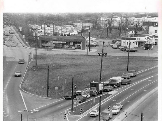
This photo of the Reed Brothers Dodge site was taken later in 1971, after the business had been relocated to 15955 Frederick Rd. and the buildings had been razed. (Montgomery History, photo by Bob Pusey)

2012 – Google Earth Aerial view showing the original location of Reed Brothers Dodge, now Veterans Park
4 responses to “Aerial Views”
Leave a comment
Books
![]()
Recent Comments
| Reed Brothers on Then and Now: Commander Hotel… | |
| Reed Brothers on Then & Now: New Occidental… | |
| Courtney Wells on Then & Now: New Occidental… | |
| Mark Brezler on Then and Now: Commander Hotel… | |
| Reed Brothers on From Chauffeur to Dodge D… | |
| Reed Brothers on 90 Year Brouchure | |
| Anthony Belson on 90 Year Brouchure | |
| Michelle on From Chauffeur to Dodge D… | |
| ptkernan on Snapshots in Time: Reed Brothe… | |
| Reed Brothers on Winter’s Harvest: Ice-Cutting… |
Related Resources


Copyright Notice

Reed Brothers Dodge History (1915-2012) by Jeanne Gartner is licensed under a Creative Commons Attribution-NonCommercial 3.0 Unported License.

“1920s – Original Reed Brothers facility at the intersection of Veirs Mill Road and Rockville Pike. Note the unpaved dirt road.”
The photo with the above-quoted caption depicts what appears to be the Veirs Mill Road B&O railroad bridge near the top of the picture just left of center. It also shows what looks like the smaller Stonestreet bridge at the left.
I have looked into the history of Veirs Mill Road and some maps purportedly dated after this photo was taken in the 1920s. Both the history and the maps indicate that the bridge over which Veirs Mill Road crosses the railroad was not completed until 1937 – a couple of years after a school bus accident at the (since closed) Baltimore Road level crossing. So can you please tell me if the bridge in the photo is Veirs Mill Road crossing the B&O and if it was an ‘official’ or public bridge or a private bridge during the 1920s.
Thank you very much.
P.S. You have a great website for anyone interested in the history of Rockville as well as Reed Brothers Dodge (where I had work performed on my Dodge Dart)
Thank you David for visiting – and your kind words are very much appreciated. I’m relatively certain the bridge in the photo is Veirs Mill Road’s original bridge across the Baltimore & Ohio Railroad (now CSX). I have also heard it called “Pigeon Bridge”. The dates of the photos are approximate, but probably the late 1920s – 1930s. Thanks for reading and taking the time to leave your comment.
Thank you for replying.
You have two 1920s aerial pictures here – the aforementioned one looking southward and showing Veirs Mill Road and the one just below it, looking eastward, that shows Rockville Pike at the bottom with Reed Brothers behind it and then St Mary’s. Behind St Mary’s is Baltimore Road and the B&O railroad tracks – and the very railroad crossing where the 1935 school bus accident occurred. These two photos were taken at different times of the year as indicated by the tree foliage. The trees in the east-looking view also look smaller, so this photo may have been taken at a much earlier date.
The school bus, in the April 11, 1935 accident, was returning Williamsport High School students from a trip to a University of Maryland science fair. As Williamsport is near Hagerstown, the logical route would have been to take University Lane, now rt 193, to Veirs Mill and head north to Hungerford Drive, now rt 355, as these roads were fully paved by 1933. Had there been a bridge at Veirs Mill, the bus would have surely taken it. Instead, it made a right turn on First Street (now rt 28) and a left turn on Baltimore Road, en-route to its fateful encounter with a B&O express train. Fourteen students in the back half of the bus were killed in this tragic accident which prompted the closing of the railroad crossing and the building of the Veirs Mill Bridge (completed 1937). It also resulted in a permanent ban on Montgomery County school buses on level crossings.
The bridge in the southward-looking photo looks like it may have been under construction at the time of the photo, which would date it between 1935 and 1937. Nearby Congressional Airport opened in 1929, a likely date for the eastward-looking photo. But whatever the exact date, these photos represent a valuable piece of Rockville history.
1935 bus/train accident story:
http://articles.baltimoresun.com/1995-04-09/news/1995099001_1_williamsport-dead-students-washington-county
Very sad story.
I appreciate your attention to detail and feedback regarding these photos. I agree with you that the bridge may have been under construction at the time.
I found a Kindle edition of “The Rockville Tragedy” available on Amazon: http://www.amazon.com/Rockville-Tragedy-Debra-Carbaugh-Robinson-ebook/dp/B007GDUVHQ which pays tribute to all of those affected by the tragedy at the railroad tracks.
Thanks again for your input and for visiting.