
Reed Brothers Site History
For over a half-century at the triangle, Reed Brothers Dodge became a community icon and a local landmark for motorists traveling to and through Rockville. Recently, I have been interested in discovering more about the early history of the Rockville Garage, which was originally located in the triangle at the intersection of Veirs Mill Road and Rockville Pike. I wanted to know “what was there before” and “how and when it got there”. Sometimes it can be hard to imagine just what a building, street, or neighborhood looked like a century ago. A little bit of creative research can uncover a wealth of information in records that were intended to serve a different purpose, and valuable information can be found from unexpected sources like the Sanborn maps. This page features a series of historical Sanborn Fire Insurance Maps of Rockville to illustrate how Rockville Garage/Reed Brothers Dodge evolved in the city’s built environment from 1915 to 1960.
From the late-1800’s to the mid-1960’s, the Sanborn Map Publishing Company of New York City created complex footprint maps of approximately 13,000 American cities. Fires were an all-too-common danger, sometimes wiping out major portions of a block. Insurance companies went to great lengths to know what they were insuring. They periodically sent out map-making teams to gather information about the buildings in cities they served. Rockville was one of those cities. The Sanborn Fire Insurance Company produced maps of Rockville in 1892, 1897, 1903, 1908, 1915, 1924, 1949, and 1960.
Along with each map is a photograph that provides a visual of how Reed Brothers Dodge grew over the years. These maps provide a detailed picture of Rockville Garage/Reed Brothers Dodge at different stages in its 55-year history at the triangle. (click images to enlarge)
Aug 1908 Rockville Sanborn Map

Aug 1908 Rockville Sanborn Map (zoomed in)
Throughout the late 19th and early 20th centuries, Sanborn maps were regularly updated as cities and towns grew and changed. Specific changes in an individual site such as when a building was built, expanded, or torn down, can often be dated within a reasonably accurate time frame, depending on how many different map editions for that city are available. These maps provide a very detailed picture of Reed Brothers Dodge at different stages in its history.
The Aug 1908 Sanborn map shows the junction of Rockville & Georgetown Turnpike and Washington Road before the Rockville Garage existed. The map reveals three, two-story dwellings. Letters A, B, and C in front of the dwellings are arbitrary identifications supplied by the Sanborn Map Company. These identifications were necessary in the absence of official numbers actually posted on the buildings.
The Montgomery County Agricultural Society fairgrounds (aka Rockville Fair) was located directly across the Rockville & Georgetown Turnpike. Compared to the Rockville of today, the sparseness of structures in this 1908 map really stands out.
Nov 1915 Rockville Maryland Sanborn Map

Nov 1915 Rockville Maryland Sanborn Map, Sheet 5 (zoomed in)
The zoomed-in image of the Nov 1915 map shows the one-story Rockville Garage at the junction of Rockville & Georgetown Turnpike and Washington Road. Lewis Reed and brothers Robert and Griffith Warfield established the Rockville Garage in this location after acquiring the building from Lee Ricketts and Sons in July 1915. These maps are quite specific, not only in representing graphically the dimensions of buildings and spaces around them, but also in the details of the construction materials and activities that took place there. Notations on this map indicate that the garage had a 15-car capacity as well as a single 285 gallon buried gasoline pump. You can also see notes written in regarding building features such as “Heat: Stove In Office”— “Lights: Electric”— “Earth Floor”. They also noted the buried gas tank and where it was located with a small circle. The number “28” represents the official designation for the block provided by the city or arbitrarily by the Sanborn Map Company. The triangle is currently occupied by Rockville Garage, five two-story dwellings, and one vacant lot. Lewis Reed began his expansion in 1917 with a two-story addition behind the original garage.
Note: “CADIZ ALLEY” is an arbitrary designation supplied by the Sanborn Map Company in the absence of a suitable official name. “Cadiz Alley” would later become “Dodge Street”.

Original 1915 Rockville Garage located at the intersection of Veirs Mill Rd and Rockville Pike. The single gas pump can be seen in front. The roofs of three two-story dwellings are visible behind the garage.
Nov 1924 Rockville Maryland Sanborn Map

Nov 1924 Rockville Maryland Sanborn Map, Sheet 7 (zoomed in)
This enlarged view from the 1924 map shows the garage capacity increased to 30 cars. If you look closely, you can see the annotations “G.T.” by four open circles—these indicate the gasoline supply is stored in tanks buried just in front of the building. Solid black circles mark the location of fire hydrants. The dealership’s Office is identified by “OFF”. Saint Mary’s Church and Cemetery is also visible where it still stands today. Other notes written in regarding building features include “Heat: Steam”— “Lights: Electric”. The small circles in the corners of the main building indicated it had a slate or tin roof. The numbers immediately in front of the buildings facing the streets are the official address numbers.

Reed Brothers Dodge got a new remodel in 1921. The original part of the garage was converted into a new car showroom and the service operation was moved out into the rear portion of the building. The Rockville Fairgrounds are beyond the boarded fence. Photo by Lewis Reed
By tracking Reed Brothers Dodge on successive Sanborn maps—1915, 1924, 1949 and 1960—I have confirmed a couple of things. First, Lewis Reed purchased a total of 6 residential lots in the triangle to expand his business. The expansions took place over the course of about 50 years—from 1917 to about 1953. Second, and more curiously, sometime between 1924 and 1949, Cadiz Alley became “Dodge Street”. The street was named “Dodge Street” by the State of Maryland sometime following the dealership’s 1941 expansion. The number “28” marks the spot where Reed Brothers constructed completely new buildings for the Parts and Service Departments.
June 1949 Rockville Maryland Sanborn Map, Sheet 10

June 1949 Rockville Maryland Sanborn Map, Sheet 10 (zoomed in)
After 1924, there is a large gap in the sequence of Sanborn maps, and the next survey was published in 1949. This map shows the expansion of the showroom and Gulf Gas Station that took place in 1941. At about the same time the gas station was remodeled, Lewis Reed split up the Sales, Parts, and Service operations by constructing a complete new building; it was located at the intersection of Montgomery Avenue and Dodge Street. By this time, Cadiz Alley had been renamed, “Dodge Street.”
In this image of the June 1949 map, you can see notes written within the “Auto Repair” building regarding construction materials such as “Cinder Block”—“Steel Trusses”— “Pilasted Walls”—”Conc. Fls”. This map reveals that Reed Brothers has implemented automatic sprinklers throughout Auto Sales & Service as indicated by the symbol “AS” within a circle. The solid black circle with “D.H.” at the top of the map identifies a Double Hydrant. New buildings for Auto Sales & Service and Auto Repair have replaced dwellings A, B, and C. One remaining two-story dwelling stands near the back of the dealership, in front of the new Parts and Service building. Block number (28) has been changed to “97”.

Late-1940s aerial view of Reed Brothers at the intersection of Veirs Mill Road and Rockville Pike. A two-story house stands behind the dealership. Photo taken by Lewis Reed from a Goodyear Blimp.
June 1949 Rockville Sanborn Map, Sheet 10, Revised Jan 1960

June 1949 Rockville Sanborn Map, Sheet 10, Revised Jan 1960 (zoomed in)
This final map is a new report that was updated in Jan 1960. Due to changes in the highway in 1953, Reed Brothers began an extensive remodeling and rebuilding program. The program consisted of a sizable addition to the service shop which enlarged the showroom area and housed the Parts Department. Two-thirds of the original location at the junction of Montgomery Avenue and Veirs Mill Road was razed and a modern Gulf Service Station was erected. The zoomed-in map reveals the new Gulf “ice box” design filling station in front. The last two-story house was demolished and replaced with a parking lot and used car lot, which now completes the triangle.

1960s aerial view showing the used car lot where previously stood a two-story house. The top left portion shows the location of the Rockville Fire Department Carnival Grounds. Photo by Lewis Reed
Note: the small white frame structure near the intersection in the upper left section is Dr. Stonestreet’s medical office, already relocated twice from its original location on Stonestreet’s property on Monroe St., and about ten years before it would be donated to the historical society and relocated to the Beall-Dawson House property.
1971
In 1970, Reed Brothers Dodge relocated its business to a brand new service complex at 15955 Rockville Pike, several miles north of its old location. The buildings on the Dodge Street site were all demolished to allow for re-routing of the Veirs Mill Road and Rockville Pike intersection.
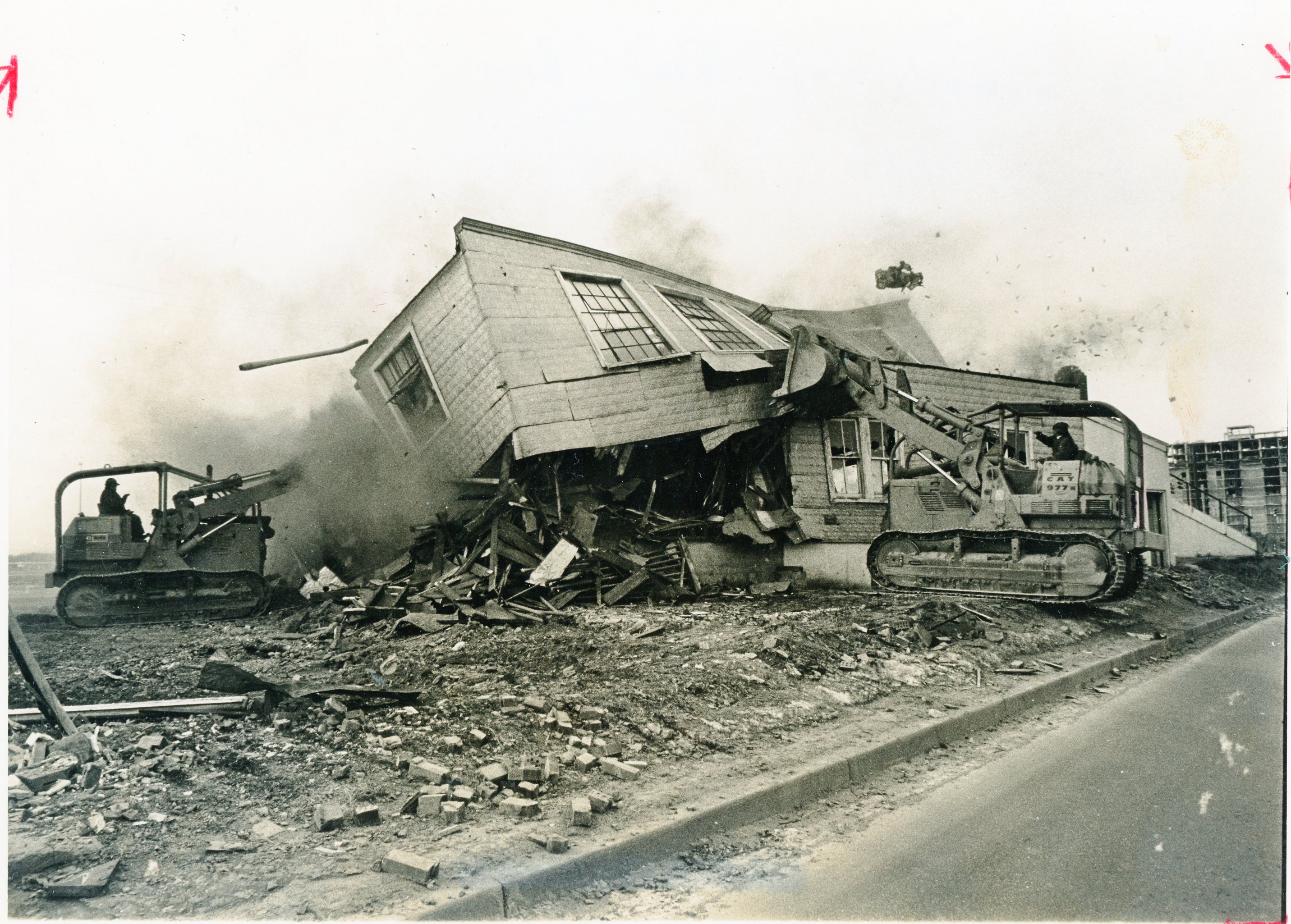
February, 1971: demolition of the original Rockville Garage buildings, which had stood on the Veirs Mill/Rockville Pike location for more than fifty years. (Montgomery History, Sentinel Photo Morgue)
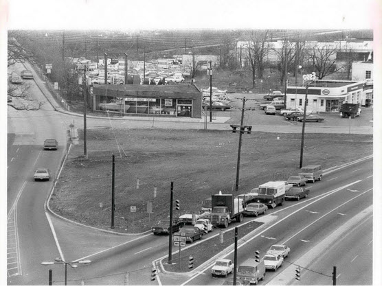
This photo of the Reed Brothers Dodge site was taken later in 1971, after the business had been relocated to 15955 Frederick Rd. and the buildings had been razed. (Montgomery History, photo by Bob Pusey)
Today, Sanborn maps are rarely used by insurance companies, having been supplanted by new technologies. However, these maps remain a vital source of historical information. The Sanborn Fire Insurance Company’s maps are a great way to get a visual sense of the development and changes that took place in a city over time. Today, they can be invaluable for uncovering a business’s long-lost historical details.
Note: All map screenshots in this post are courtesy of the Library of Congress digital collection of Sanborn maps.
Books
![]()
Related Resources


Copyright Notice

Reed Brothers Dodge History (1915-2012) by Jeanne Gartner is licensed under a Creative Commons Attribution-NonCommercial 3.0 Unported License.

Recent Comments