
Then & Now: Washington Union Station 106 Years Apart
In this special post, I have combined one of Lewis Reed’s original photograph’s for “then” and matched it with a corresponding contemporary shot for “now” to see how the location has changed or remained nearly the same through the years. I started doing this as a research tool, now I mostly do it because of my passion for history and fascination with the subject. In the following photographs, you can see the difference 106 years can make.
Washington Union Station (THEN): Seen in the black & white photograph taken by Lewis Reed in 1912, is Union Station in Washington, DC. Union Station is one of the country’s first great union railroad terminals. Designed by renowned architect, Daniel Burnham, the station opened on October 27, 1907 and was completed in April 1908. At the height of its traffic, during World War II, as many as 200,000 passengers passed through the station in a single day. Today, Union Station is one of the busiest rail facilities and shopping destinations in the United States, and is visited by over 40 million people a year.
Visible in both photos is the Columbus Fountain also known as the Columbus Memorial which serves as a tribute to the explorer Christopher Columbus. The fountain sits in the center of the Columbus traffic circle in front of Union Station.

Washington Union Station, 1912. Photo by Lewis Reed
Washington Union Station (NOW): The same view over a century later. The difference? Color.

Washington Union Station today
Then & Now: Halpine Store/Radio Shack 111 Years Apart
Looking at old photographs is like peering through an open window back into history. Not only do they give you a sense of wonder from traveling back in time, but also a staggering feeling of awe from seeing just how much things have changed. For this post, I have used one of Lewis Reed’s original photographs for “then” and a Google Maps street view image from today for “now”.
The Halpine Store (THEN): The Halpine Store, also known as the Lenovitz General Store, was built on Rockville Pike in 1898, taking advantage of the prime location on the trolley and railroad lines and the Pike. The store sold food, gasoline and other items to locals and Pike travelers. The man standing just in front of the trolley tracks is James H. Handy (b. 1890) who lived at Halpine and worked for Mr. Copeland on the Wilkins farm. Handy served in the U.S. Army during WWI, as a gunner for the 371st infantry, doing two tours of duty in France. In this photo, he is about 16 years old. Note the telephone or telegraph poles, and the trolley tracks paralleling the road. The nearby Halpine railroad station also brought customers to the area, and the store became the social/community gathering place for the Halpine area. Tradition has it that during the days of “Local Option” when the sale of alcoholic beverages was forbidden in the County, the men of Rockville traveled to the Halpine Store to gather on the broad front porch and sip its special brand of “coffee” served in tin cups.
The proprietors, Benjamin and Anna Lenovitz, lived on the second floor. The building burned in 1923 and a new fire-resistant brick building was rebuilt in its place. This building, at 1600 Rockville Pike, became a Radio Shack, selling computers and electronics.
Seen in the black & white photograph taken by Lewis Reed in 1906, is The Halpine-Lenovitz General Store at Rockville Pike and Halpine Road.

Halpine-Lenovitz General Store at Rockville Pike and Halpine Road, 1906. Photo taken by Lewis Reed.
The Halpine Store/Radio Shack (NOW): The same view one hundred and eleven years later. Rockville Pike is now six lanes, linking the once outlying Halpine and Montrose with Rockville’s town center in one long strip of commercial enterprises and office buildings.

Halpine Store/Radio Shack, Google Image Capture, Nov 2016
Source: Maryland Historical Trust
U.S. Capitol Then & Now… 108 Years of Change
You might not realize how much Washington DC has changed until you look back and see what it looked like in the past. I thought it would be fun to revisit an historic location using one of Lewis Reed’s original photographs for “then” and a stock image from today for “now” to see what differences are visible. In the following photographs, you can see how the United States Capitol looks both the same and completely different from a century ago.
U.S. Capitol (THEN): Seen in the black & white photograph taken by Lewis Reed in 1910, is the United States Capitol in Washington, DC. Visible in both photos is the white marble Peace Monument that stands in the circle to the west of the U.S. Capitol at Pennsylvania Avenue and First Street, NW. A streetcar can also be seen in the black & white photo. The Pennsylvania Ave streetcar line ran from Georgetown, across Pennsylvania Avenue, past the White House, up to Capitol Hill, and then down to the Navy Yard. With no stop signs, speed limits, or lane lines, the streets of the early 1900s were completely different.
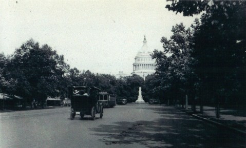
U.S. Capitol as seen from Pennsylvania Ave in 1910. Photo by Lewis Reed
U.S. Capitol (NOW): The same view over a century later hasn’t changed much… except for the traffic and Segway riders with fanny packs.
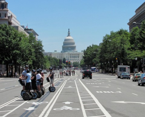
On Pennsylvania Ave and U.S. Capitol building today. A Segway tour is stopped along the bike lanes.
Then & Now: Georgetown University and Potomac Aqueduct Bridge 100 Years Apart
Washington DC has a lot of history. The Smithsonian museums, the monuments, etc., but it is interesting to see just how much the city has changed over the years. I thought it would be fun to revisit an historic location using one of Lewis Reed’s original photographs for “then” and a stock image from today for “now” to see what differences are visible. In the following photographs, you can see how Washington, DC looks both the same and completely different from a century ago.
Georgetown University and Aqueduct Bridge (THEN): The Key Bridge was not the original connector between Georgetown and Virginia. Prior to that construction in the 1920s, there were two iterations of the Aqueduct Bridge. The second iteration of the bridge looked visibly different, but even that one suffered from deterioration and was only used between 1889 and 1918. The Aqueduct Bridge continued as a bridge for traffic until the Key Bridge opened in 1923.
Seen in the black & white photograph taken by Lewis Reed in 1913, is the Aqueduct Bridge over the Potomac River in Washington, DC. The spires of buildings at Georgetown University can be seen in the background.
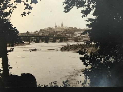
Potomac Aqueduct Bridge Washington DC 1913. Photo by Lewis Reed
Georgetown University and Key Bridge (NOW): The same view over a century later hasn’t changed much.

Georgetown University and Key Bridge Washington DC today
Reed Brothers Dodge Featured in Montgomery Magazine
 Reed Brothers is very proud and honored to be featured in the month of April/May 2017 Montgomery Magazine, historic landmarks “Then & Now” section. The black and white photograph above is Reed Brothers Dodge located at its original location in Old Rockville at the triangle at Veirs Mill Road and Rockville Pike – close to 100 years ago – with “That Good Gulf” gasoline drive-through filling station and Dodge Brothers Motor Car and Graham Brothers Truck signage. The Alemite sign in front indicates that Reed Brothers also sold and used the Alemite lubricating system.
In 1918, the Gulf Refining Co. adopted a brick and tile roof station with canopy supported by four brick columns covering two front driveways. “That Good Gulf” was one of the Company’s marketing slogans for a number of years during the twenties and thirties. The second story was added to the showroom with a glazed front looking out onto Rockville Pike on the right. The photo was taken by Lewis Reed in the late 1920s. Note the unpaved dirt road on Rockville Pike and trolley tracks running past the dealership. (click on images to enlarge)
 The color photograph above, is the dealership’s location today, now known as Veterans Park. In the 1970s the site was known as the Francis Scott Key Memorial Park, and later in 1988, it was permanently rededicated as Veterans Park. In the late 1960s, the state of Maryland acquired the land to widen 355 and donated the remaining sliver to the City. The state named the connector street behind the dealership’s location “Dodge Street” because Reed Brothers Dodge dealership was located there for more than 50 years.
Montgomery Magazine is a lifestyle magazine, with timely articles on county leaders, entertainment, sports, neighborhood and restaurant profiles, entrepreneurs, historic landmarks then and now, plus seasonal special sections of local interest.
Find the issue online at: http://www.montgomerymag.com/MM_Newsletters.html
Books
![]()
Related Resources


Copyright Notice

Reed Brothers Dodge History (1915-2012) by Jeanne Gartner is licensed under a Creative Commons Attribution-NonCommercial 3.0 Unported License.

Recent Comments