
Then & Now: The Leesburg, VA Passenger Station
The story of the Leesburg Passenger Station becomes even more vivid when viewed through the lens of Lewis Reed, the prolific early 20th-century photographer from Montgomery County, Maryland, whose work documented key moments and locations throughout the region. Reed’s images are renowned for their ability to capture everyday details of local life, including transportation scenes and important sites in Virginia and the greater Washington area.
Leesburg Passenger Station (THEN): When the Alexandria, Loudoun, & Hampshire Railroad (later W&OD) arrived on May 17, 1860, Leesburg realized a dream. A local newspaper praised the railroad, which “throws us within an hour or two’s ride of the cities of the seaboard, and opens up a new avenue of commerce and trade.” At first a single depot, located 0.2 mile east of here, served passengers and freight. In 1887 the railroad opened a separate passenger station here at King Street. It remained in use until passenger service ended in 1951.
Even as the passenger station itself vanished, Reed’s visual archives ensure its memory stays alive. His photographs remain a valuable bridge for comparing “then & now,” letting viewers step back in time and appreciate the evolution of Leesburg, one carefully developed print at a time. The continuing presence of Reed’s work in books and exhibits means the Leesburg Passenger Station is still seen and experienced today, long after trains have passed and the site has become part of the Washington & Old Dominion Trail.
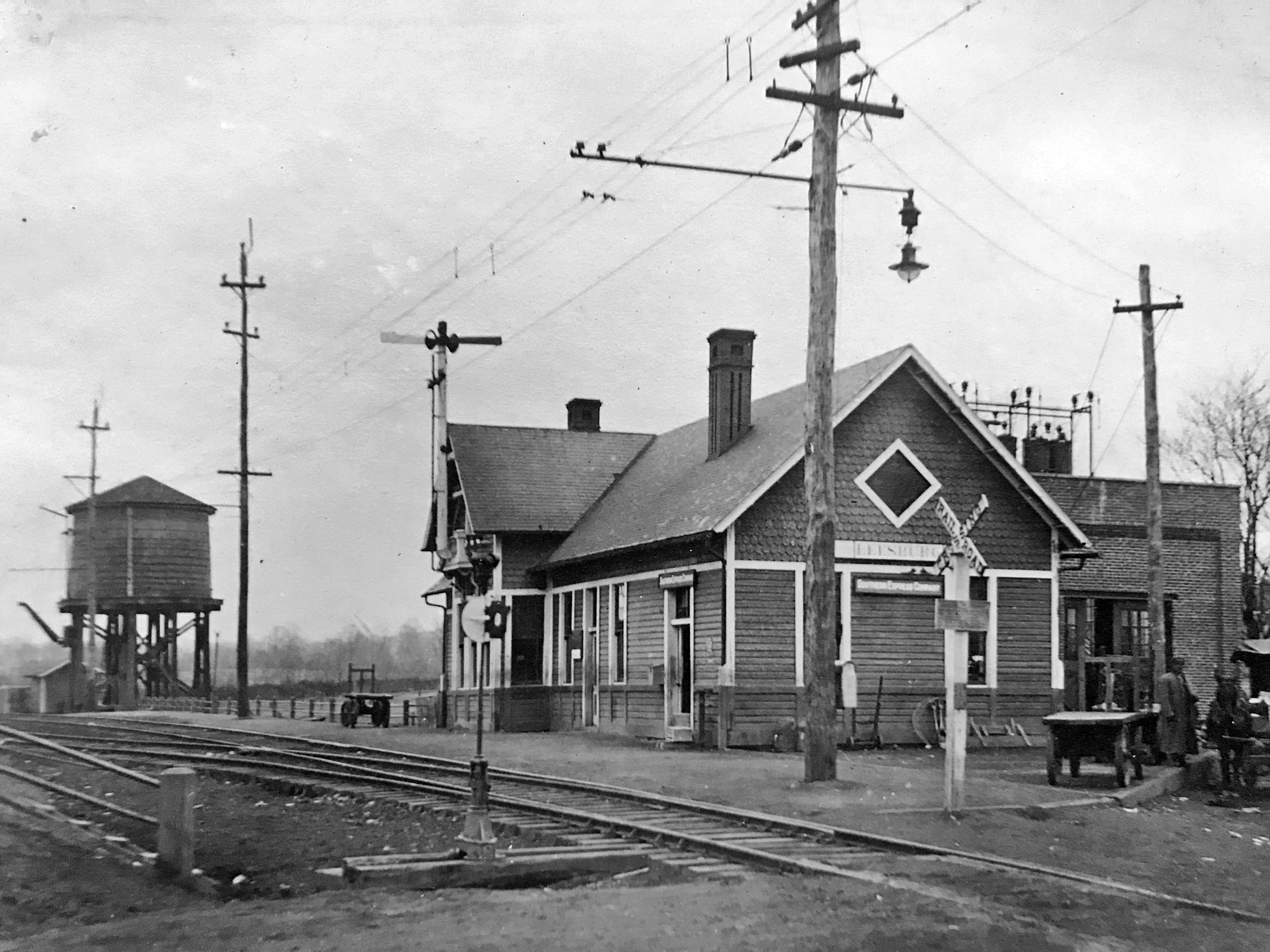
A historic photograph of the Leesburg Passenger Station captured by Lewis Reed showing the depot in its early 20th-century setting.
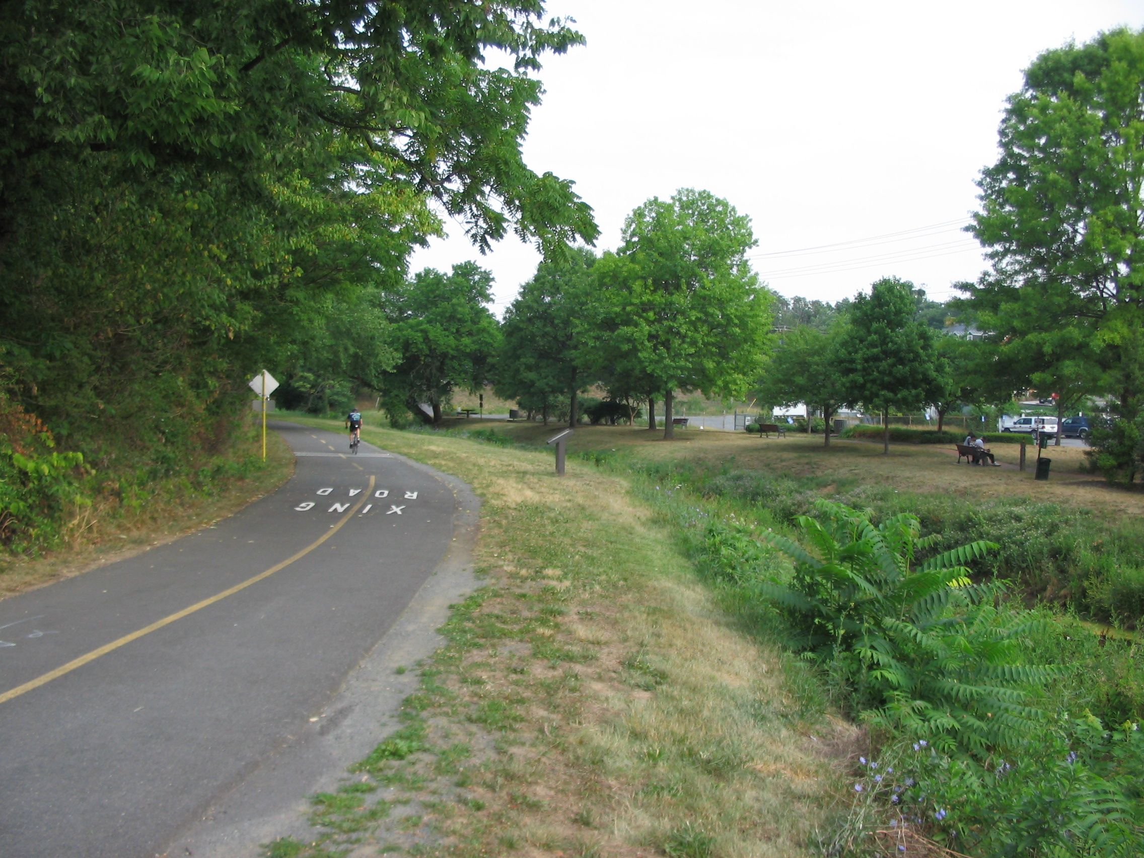
Leesburg Passenger Station Marker seen from King Street today.
The Leesburg Passenger Station remains a rare survivor of Loudoun’s rail era, an enduring symbol of how a small wooden depot could once shape the rhythm of a town. Its transformation from active rail stop to preserved trail-side icon connects past and present, reminding us that even as technology changes, the places that ground a community can still hold meaning.
Then & Now: Reed Brothers Dodge and the Changing Face of Rockville
The story of Reed Brothers Dodge is also the story of how Rockville and Montgomery County grew up around the automobile. Through the lens of founder Lewis Reed, we can watch that transformation unfold one frame at a time.
THEN: A Corner Garage on a Dirt Road
In the early 1900s, Rockville was still very much a rural crossroads. When Lewis Reed opened his original Rockville Garage in 1915 at the intersection of Veirs Mill Road and Rockville Pike, the scene looked nothing like the busy corridor we know today.
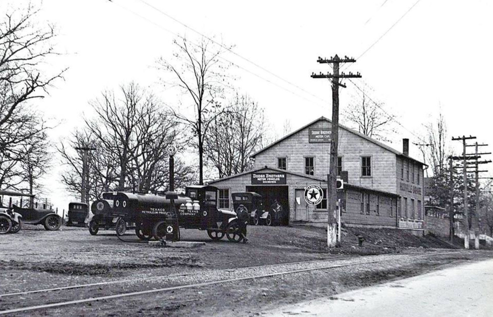
THEN: 1917 Rockville Garage, later expanded with a two-story addition. A Texaco Filling Station sign is visible alongside a Texaco petroleum fuel truck servicing the single pump out front.
In the historic photograph, you can see:
- An unpaved Rockville Pike, more dirt than road, stretching into the distance.
- Trolley tracks running past the garage, part of the transit line that connected Rockville to Washington, D.C. from 1900 to 1935.
- A simple building front with “Dodge Brothers Motor Vehicles” signage, more workshop than showroom.
It was a modest operation by modern standards, but it represented something new: a dedicated place in town for motorists to buy, fuel, and service their automobiles. At a time when horse‑drawn wagons still shared the road, Reed Brothers Dodge stood at the frontier of a new way of moving through the world.
NOW: From Quiet Crossroads to “Mixing Bowl”
Stand in the same spot today and it is almost hard to believe it is the same place. The once‑quiet junction has evolved into what locals now refer to as “the mixing bowl,” a complex web of roads, traffic signals, and near‑constant traffic.
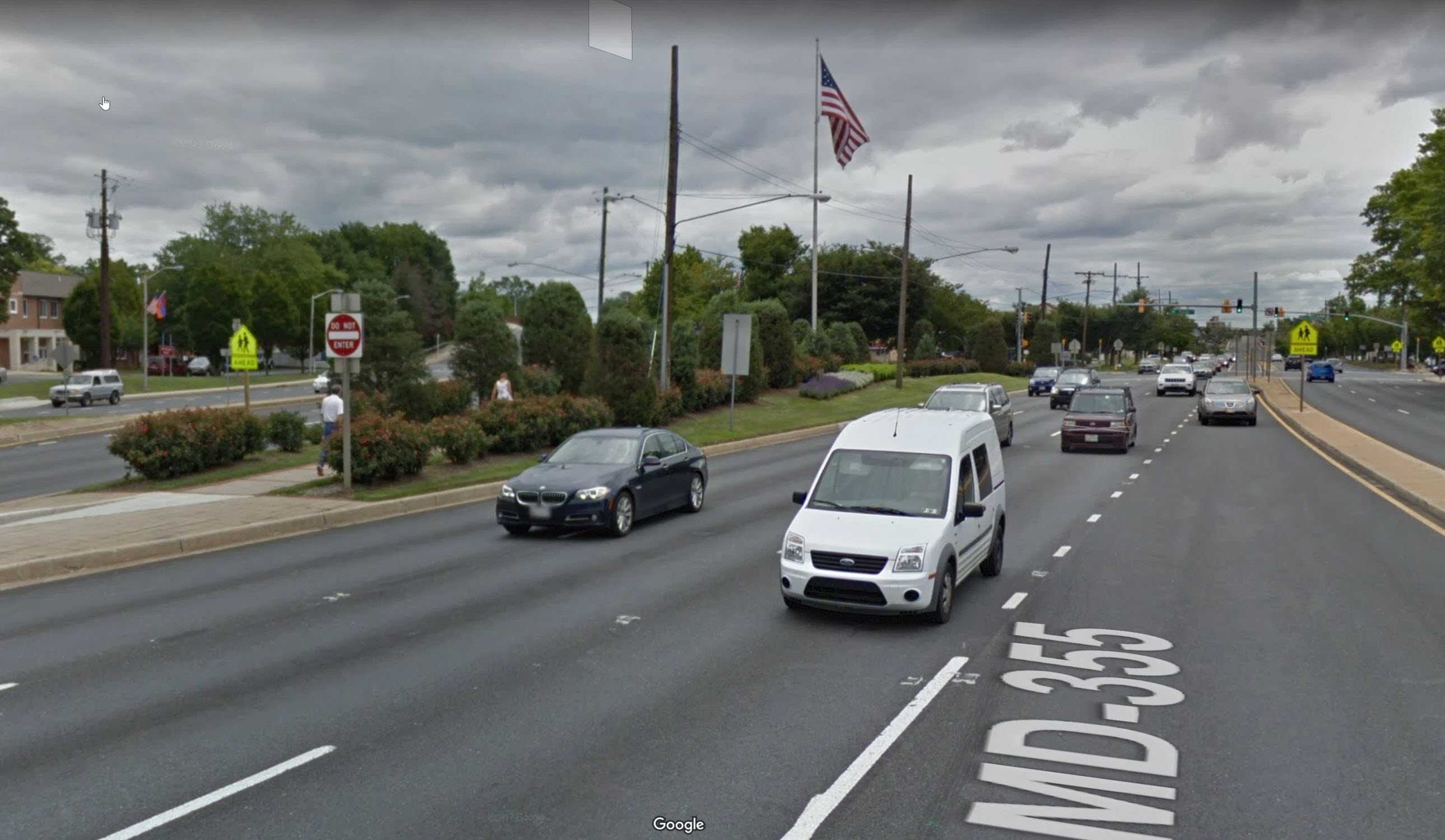
NOW: Veterans Park occupies the former Reed Brothers Dodge corner at Rockville’s “mixing bowl,” a small green refuge with flags and pathways set against the backdrop of constant traffic and busy highways.
Where the original Reed Brothers building once stood, the landscape has cycled through multiple lives:
- In the decades that followed, the busy crossroads gave way to highway progress, as road‑widening projects in the 1960s and 1970s carved away much of the original Reed Brothers property.
- The once‑bustling dealership site was gradually transformed into what is now Veterans Park.
- With the demolition of the dealership building in 1970, nearly half a century of automotive history at that corner came to a close, leaving only photographs and memories to mark its presence.
Today, the same view is dominated by multi‑lane roads, turning lanes, and signage, where there were once dirt streets, trolleys, and the old Rockville Fairgrounds just across the Pike.
A Dealership That Grew with Its Community
Reed Brothers Dodge did not stand still while the roads changed. Founded in 1915, the family business survived World War I, the Great Depression, World War II, recessions, and Chrysler’s financial crises of the 1970s and 1980s.
Key milestones include:
- Expansion from a small corner garage into a full Dodge dealership as automobile ownership grew.
- Construction of a new showroom and service building at East Montgomery Avenue and what would later be named Dodge Street in the 1940s.
- A major relocation in 1970 to a modern facility at 15955 Frederick Road in front of the Shady Grove Metro, complete with contemporary showroom and full service complex.
By the time the dealership closed in 2012, Reed Brothers Dodge had operated in Rockville for more than 97 years, making it the longest‑running Dodge dealership in Montgomery County history.
This single pair of images is just one chapter in a much larger visual record. Lewis Reed’s photographs capture everyday life across Maryland and beyond from 1898 through 1960. Many of these scenes can still be recognized today if you know where to look, even as roads have widened, buildings have vanished, and new neighborhoods have emerged. You can explore the entire “Then & Now” series with Lewis Reed’s photographs here: https://reedbrothersdodgehistory.com/category/then-now/.
Then and Now: Hotel Cape May, 1919
People have been visiting Cape May, “the nation’s oldest seashore resort,” for longer than America has been a country. That makes Cape May the perfect place to look back on over 100 years ago and from today — then and now.
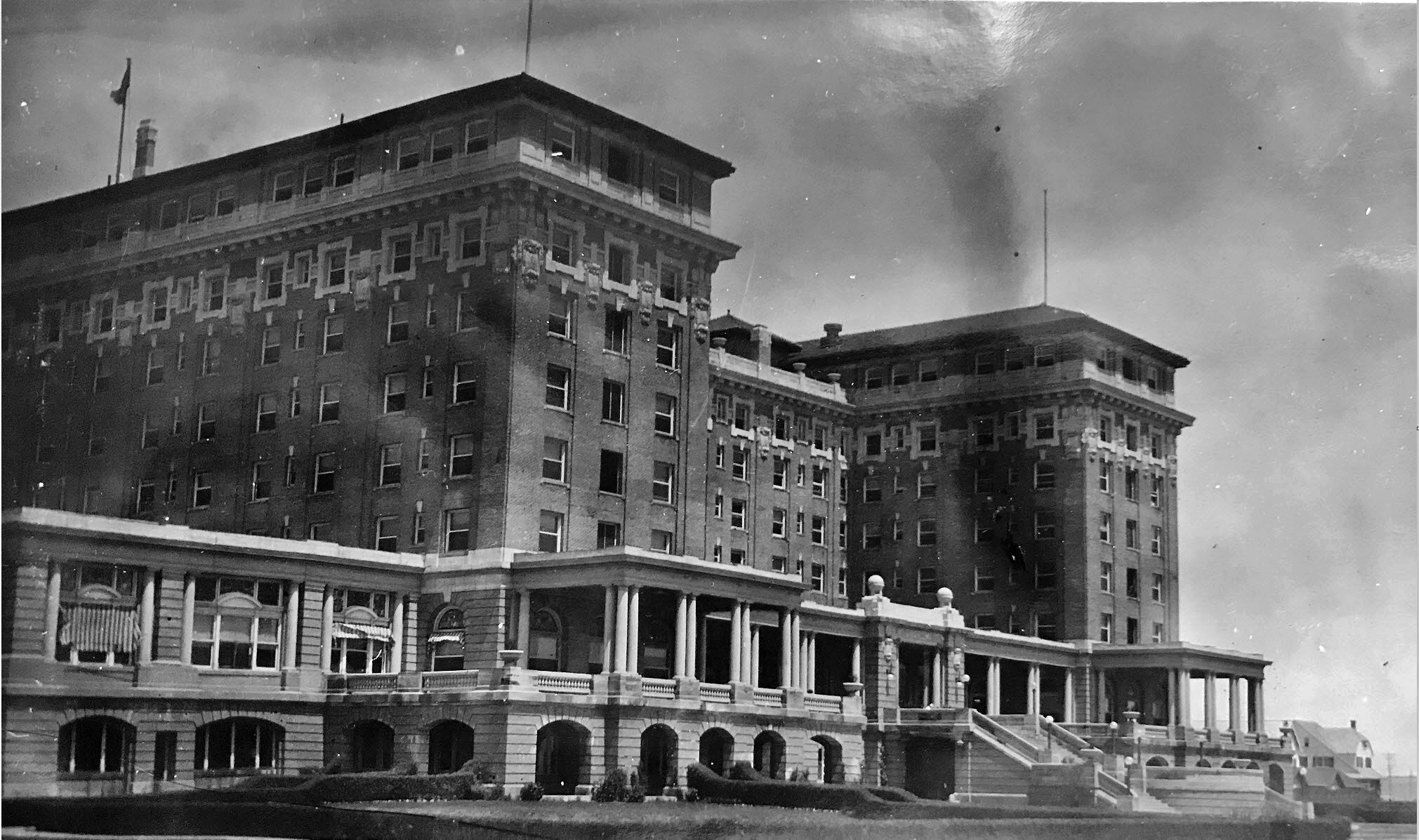
A bit of Hotel Cape May history: The Christian Admiral, formerly Admiral Hotel and Hotel Cape May, was a luxury beachfront hotel located in Cape May, New Jersey. Opened in 1908, as the Hotel Cape May, the ornate hotel was abandoned five years later due to bankruptcy. It was then sold at a Sheriff’s sale. The hotel was leased by the War Department as a hospital from 1918-1919 during WWI. Afterwards, it was again abandoned. In 1932, the Admiral Hotel company purchased it and renamed it the Admiral Hotel. They too went bankrupt in 1940. The military returned for WWII from 1941 to 1945 and afterwards it was once more sold at Sheriff’s sale. It opened and closed multiple times before being abandoned again in the 1950s. Reverend McIntire saved it from demolition in 1963, and operated it until his organization too, went bankrupt. The Christian Admiral never made a profit for any of its owners and was the cause of six bankruptcies. Nonetheless, it was a gorgeous hotel and one of the most recognizable and beloved buildings in Cape May. The people who liquidated McIntire’s organization shopped the hotel around, but it was deemed too far gone to save. Engineer estimates were $20 million and above, just to make it structurally sound and from $60-$80 million to restore it. The hotel was razed in 1996.
Hotel Cape May (THEN): The Christian Admiral Hotel, originally known as the Hotel Cape May, was erected in the Beaux-Arts style between 1905 and 1908. When opened on April 11, 1908, it was the world’s largest hotel. Completed behind schedule and over budget, Hotel Cape May was part of a development project intended to bring wealthy visitors to the city and rival East Coast resorts such as Newport, Rhode Island. During its existence it would undergo five bankruptcies and ownership changes.
Edgar was a partner with his brother Lewis Reed, in Reed Brothers Dodge. During WWI, Edgar served as a Sergeant in the U.S. Army Medical Corps from February 1918 to August 1919 and had been posted to GENERAL HOSPITAL NO. 11 in CAPE MAY, NEW JERSEY. The spirit of patriotic service which swept the country prompted many persons to offer their properties to the War Department for hospital purposes. These offers included buildings of every conceivable kind, such as department stores, private establishments, hospitals, and properties in large cities. It was found that many of these could be obtained and converted into hospitals much more expeditiously than barrack hospitals could be constructed, and at less cost.
The Surgeon General recommended that the War Department authorize the leasing of the Hotel Cape May for use as a general hospital on December 18, 1917. The Hotel Cape May was located on the Ocean Drive, at the eastern end of the city, and within 100 feet of the beach of the Atlantic Ocean. Opened first as GENERAL HOSPITAL NO. 16, the designation was changed to GENERAL HOSPITAL NO. 11, March 14, 1918. The enlisted personnel were quartered in tents which were located to the rear of the building.
Hotel Cape May as it looked in 1919. Photo by Lewis Reed.
The Christian Admiral Hotel (NOW): In 1991, the hotel was closed by Cape May City officials. The hotel was demolished in 1996 and the site was reused for a development of single family homes. The demolition of the hotel placed the city’s National Historic Landmark status at risk.
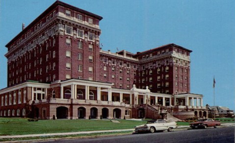
The Christian Admiral Hotel, late 1970s. Closed by Cape May City Officials, 1991 for want of tens of millions of dollars to bring up to modern codes. Destroyed: Feb, 1996.
Snapshots in Time: Reed Brothers Dodge Then and Now
Reed Brothers Dodge occupies a distinctive place in Montgomery County’s commercial and transportation history, operating as a family-run dealership for nearly a century and weathering profound shifts in American life. Established in 1915 by automobile pioneer Lewis Reed and later joined by his brother Edgar, the firm grew from a modest Rockville garage into one of the nation’s oldest continuously operated Dodge dealerships, surviving two world wars, economic downturns, and repeated upheavals in the auto industry. “Snapshots in Time: Reed Brothers Dodge Then and Now” examines this trajectory through paired historical and contemporary images, inviting readers to view the dealership not simply as a business, but as a long-running institution that helped drive Montgomery County’s transition from rural crossroads to modern suburb. (click images to enlarge)


The black-and-white photograph on the left shows Lewis Reed’s original Rockville Garage in 1915, located at the intersection of Veirs Mill Road and Rockville Pike. In the early days of the automobile, many dealerships evolved from existing repair garages, and Rockville Garage was no exception. That same year, Lewis Reed became a partner with Robert L. and Griffith Warfield. The Warfield brothers later purchased the building in July 1915 from Lee Ricketts and Sons, who had operated the local Overland agency. The business continued under the Rockville Garage name until, shortly after Edgar Reed joined his brother, it was renamed at the suggestion of the late Judge Edward Peter.
The image on the right is a 1970 artist’s rendering of the new Reed Brothers Dodge dealership, representing a pivotal moment in the company’s history. After 55 years at the original downtown triangle location, Lee Gartner purchased 4.37 acres from Eugene Casey and relocated the business to a modern facility at 15955 Frederick Road in Rockville. Featuring a contemporary showroom and a full Dodge, Chrysler, and Jeep service complex, the new site marked the beginning of a new era, while carrying forward a legacy that began nearly six decades earlier in a modest corner garage.


The black and white photograph above, taken by Lewis Reed, shows the original Reed Brothers Dodge dealership nearly 80 years ago… and on the right is the same location today, now known as Veterans Park. In the 1970s, the site was briefly called Francis Scott Key Memorial Park, before being permanently rededicated as Veterans Park in 1988 to honor those who served. During the late 1960s, the State of Maryland acquired the property to widen Route 355. The remaining portion of land was donated to the City of Rockville, and a small street created behind the dealership was named “Dodge Street”—a lasting tribute to the more than 50 years Reed Brothers Dodge called that location home. What was once a center of automotive innovation has been transformed into a quiet place of remembrance, but the legacy of Reed Brothers Dodge remains forever etched in the street signs and stories of Rockville’s past.


These photographs show the intersection of King Farm Boulevard and Frederick Road; the site where Reed Brothers Dodge stood proudly for more than 40 years. The image on the left, captured by Google Street View in April 2012, shows the dealership just before it closed its doors for the last time.
Today, the legacy of Reed Brothers Dodge continues in a new form. On the right, the property is now home to The Reed, a rebranded apartment complex that pays tribute to the site’s deep roots in local history. In early 2025, the familiar Bainbridge name officially disappeared from 15955 Frederick Road in Rockville. Along with the signage, the apartment complex underwent a complete rebranding, now honoring the legacy of the Reed family and the dealership that once stood there. Though the building is gone, the memory of Reed Brothers Dodge remains deeply rooted in the landscape and spirit of the community.


The black and white photograph above was taken by Lewis Reed in 1915, looking west from the site of his original Rockville Garage. Visible in the image is the dealership’s very first “gas station”—a single pump. In the distance, an early trolley car makes its way along Main Street (now Rockville Pike), part of a transit line that operated from 1900 to 1935, running past Reed Brothers Dodge. Also visible in the background is the historic St. Mary’s Cemetery, a landmark that still exists today.
Fast forward to the present, and the same view seen on the right looks dramatically different. The once-quiet corridor has evolved into what locals now affectionately call “the mixing bowl,” a complex web of modern roads, traffic signals, and constant motion. While the landscape has changed, the photo offers a rare window into the early days of Rockville’s automotive and transit history.


The “then” photograph above was taken by Lewis Reed in 1953 at the corner of East Montgomery Avenue and Dodge Street. It captures the newly constructed building, which housed the showroom along with the parts and service departments. When the State of Maryland widened the surrounding roads in 1970, the connector street behind the dealership’s original location was officially named “Dodge Street,” a nod to the many years Reed Brothers Dodge operated there—from 1915 to 1970.
The “now” image on the right is a Google Maps view of the same location, captured in 2016—64 years later—showing just how dramatically the area has changed over time.


Both of the “then and now” images above are Google Maps Street View photographs taken just ten years apart. The image on the left shows Reed Brothers Dodge in 2007, while the image on the right captures the same site after its transformation into the Bainbridge Shady Grove Metro Apartments.
In early 2025, the familiar Bainbridge name officially disappeared from 15955 Frederick Road in Rockville. Along with the signage, the apartment complex underwent a complete rebranding. Today, the property is known simply as The Reed, a name that pays tribute to the site’s deep roots in local history.


The 1917 photo on the left is the original Rockville Garage located at the intersection of Veirs Mill Road and Rockville Pike, 100 years ago. Note the unpaved dirt road on Rockville Pike and trolley tracks running past the Rockville Garage. Both photographs were taken by Lewis Reed on the Rockville Pike side of the dealership.
On the right, is the same location 50 years later of the Reed Brothers Dodge Gulf Gasoline station. Due to changes in the highway, Reed Brothers began an extensive remodeling and rebuilding program. Two-thirds of the original location at the junction of then Route 240 and Veirs Mill Road was razed and a modern Gulf Service Station was erected.


On the left is a mid-1960s view from the corner of Veirs Mill Road and Dodge Street showing the new building for Reed Brothers Service Department. On the right is a Google street view image of the same location today, 50 years later.


The photograph on the left shows a side view of the Rockville Garage, including its two-story addition to the original shop, taken nearly a century ago. The first floor housed the service department, while the upper level was used for parts storage. A tall chimney, likely connected to a coal furnace, provided heat, and the abundance of windows flooded the workspace with natural light for servicing early automobiles. By this time, Firestone Tire signage had replaced the earlier Fisk brand sold at Rockville Garage in 1915.
The photograph on the right was taken in 1968 from the same location, roughly 50 years later. By then, major highway changes had dramatically altered the site. Nearly two-thirds of the original property at the junction of what was then Route 240 and Veirs Mill Road had been razed, making way for a modern Gulf service station.


The beginning and the end at 15955 Frederick Road: 1970 and 2013.
The photograph on the left shows the dealership’s newly completed building in 1970, following its move from the original location at the triangle formed by Veirs Mill Road and Rockville Pike. This modern facility marked Reed Brothers Dodge’s 55th year of selling Dodge vehicles and signaled a new chapter for the business.
The image on the right was taken on May 16, 2013. The building stands vacant, photographed on the very day demolition began, bringing nearly a century of automotive history at this location to a close.


The photograph on the left shows rows of beige and baby-blue cars lined up neatly in the side lot. Just across the road stands King Farm, dominated by its large barn painted with the words “Milk for Thompson’s Dairy,” long before the land was transformed into a dense mixed-use community. At the time, Lawson King’s dairy cows grazed in fields only a few feet from the roadway. At its height, King Farm was the area’s largest milk producer and had remained in agricultural use for nearly 75 years before development was approved in 1996.
The image on the right was taken from the same vantage point in 2009, more than three decades later. The familiar barn still rises in the background, but the surrounding fields are gone, replaced by the streets, buildings, and neighborhoods of what is now known as King Farm.
Looking at these images side by side, it’s clear that progress doesn’t erase history, it builds on it. Streets may widen, buildings may disappear, and businesses may move on, but traces of what once was are still there for those who know where to look. Lewis Reed’s photographs give us a rare anchor to the past, allowing today’s landscape to be seen with new eyes. In comparing then and now, we’re reminded that Rockville’s story is not just about change, but about continuity, memory, and the people who lived and worked along these streets long before us.
Historic Tracks: Gettysburg Lincoln Railroad Station Then and Now
The Gettysburg Lincoln Railroad Station is more than just a building, it’s a piece of American history. From Abraham Lincoln’s famous journey to deliver the Gettysburg Address to the thousands of visitors who pass through today, this station has seen it all. In this “Then & Now” post, we take a look at how this iconic landmark has changed (or stayed the same!) over the years, giving us a fresh perspective on a place that helped shape our nation’s story.
Gettysburg Lincoln Railroad Station (THEN): Captured by photographer Lewis Reed in 1914, this remarkable image shows a crowd gathered along the tracks outside the Gettysburg Lincoln Railroad Station. The station’s elegant Italianate architecture with its arched windows, decorative brickwork, and central cupola stands prominently in the background. A steam locomotive waits at the platform as men in suits and bowler hats fill the scene, evoking an era when rail travel was both essential and ceremonial. The photograph offers a vivid glimpse into early 20th-century life in Gettysburg, when the railroad still served as the town’s vital connection to the wider world.
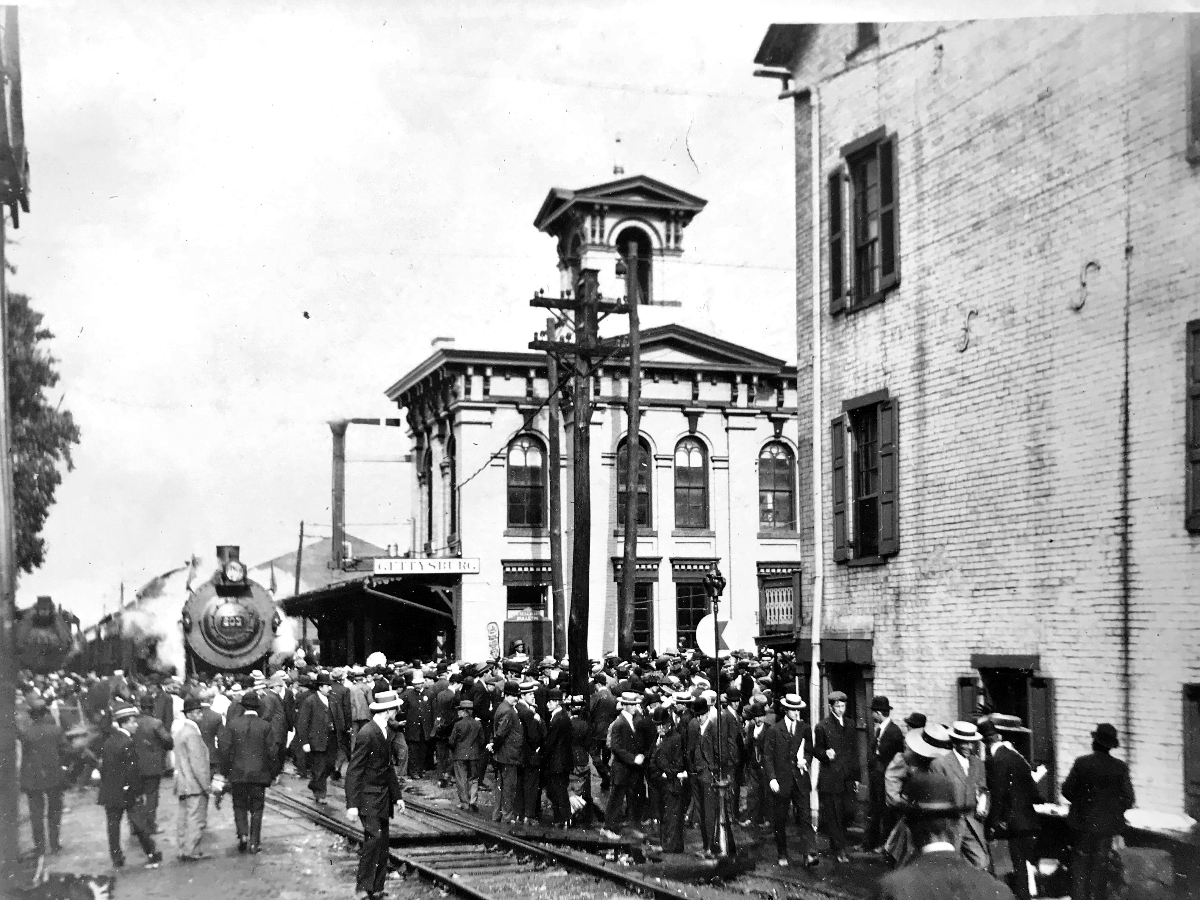
A historic photograph of the Gettysburg Lincoln Railroad Station captured by Lewis Reed in 1914, showing the depot in its early 20th-century setting.
Gettysburg Lincoln Railroad Station (NOW): More than a century later, the restored Gettysburg Lincoln Railroad Station continues to welcome visitors; though today, they come not to board trains, but to step back in time. The station now operates as a museum and visitor center, preserving the story of Abraham Lincoln’s arrival to deliver the Gettysburg Address in 1863. Its beautifully restored façade and carefully maintained details honor both its Civil War legacy and the generations that followed, ensuring this historic landmark remains a lasting link between past and present.
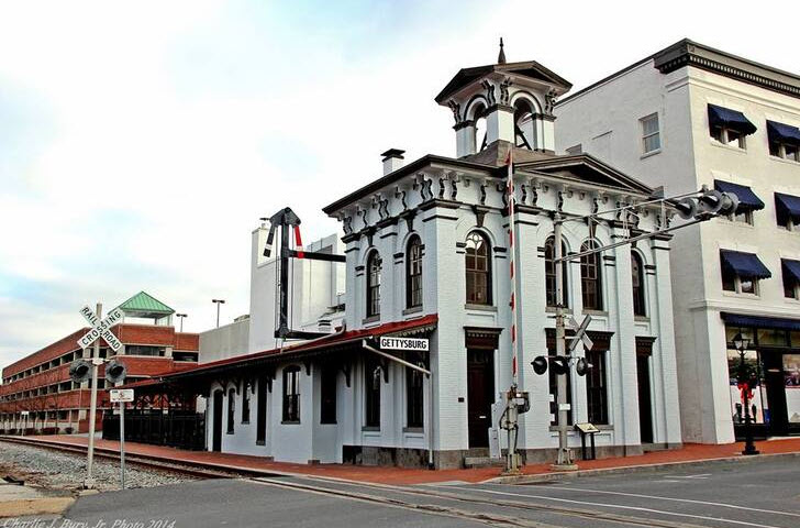
Gettysburg Railroad Lincoln Train Museum Today
Books
![]()
Related Resources


Copyright Notice

Reed Brothers Dodge History (1915-2012) by Jeanne Gartner is licensed under a Creative Commons Attribution-NonCommercial 3.0 Unported License.

Recent Comments