
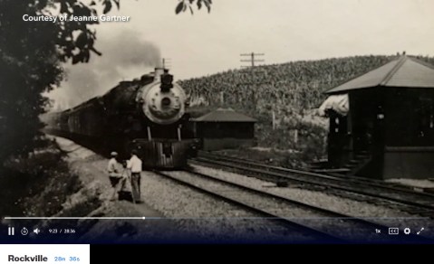
Lewis Reed Photos Featured on WETA’s “If You Lived Here” Rockville
Several of Lewis Reed’s photos were featured on a historical segment of “If You Lived Here” series on Rockville that aired on December 4, 2023 on WETA. While in Rockville, viewers learn about the history of Rockville, Maryland and the town’s transformation after World War II. The post-war era brought about a wave of growth and change.
This video is part of WETA’s house-hunting “If You Lived Here” series, which spotlights a wide array of neighborhoods and properties throughout the national capital area while celebrating each area’s history, culture, notable places and flavor. Hosts, best friends and longtime Washingtonians Christine Louise and John Begeny tour homes and communities with local realtors, exploring the D.C. Metro region one neighborhood at a time.
The following photos are screenshots of Lewis Reed’s photographs that appeared in the video. (click any image to view photo gallery)
Lewis Reed (at left) using a tripod and five-by-four box camera to shoot photos of an arriving B&O train near Germantown in 1913

Rockville B&O Railroad Station pictured here at the turn of the century.

Rockville Trolley car #596, 1908

Tenallytown and Rockville Pike Trolley Line, 1910
The “If You Lived Here” series is now WETA PBS’ most popular local show ever produced. Follow the link to watch the video of Episode 16 of Season 3 on WETA/PBS series, “If You Lived Here” Rockville.
Then & Now: 1st National Bank of Monrovia
This post is a continuation of a series of “Then & Now” images from Lewis Reed’s Photo Collection alongside photographs of how they appear today. Lewis Reed worked hard to preserve a visual history of Montgomery County, Maryland and surrounding area long before automobiles were even around. As early as 1905, he toured on his motorcycle across the states of Maryland, Virginia, and Washington, D.C. and took photographs of many historic locations. Taken approximately 113 years apart, you can see how the 1st National Bank of Monrovia Maryland looks almost the same from over a century ago.
1st National Bank of Monrovia (THEN): In 1908, the First National Bank of Monrovia was founded and the Renaissance Revival bank building was erected. The bank was merged with the Central Trust Company in 1916 and closed in the early 1930’s in the aftermath of the 1929 stock market crash and ensuing Great Depression of the 1930’s.

1st National Bank of Monrovia. Photo by Lewis Reed, 1910
1st National Bank of Monrovia (NOW): The bank is now the office of a construction company.
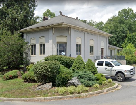
The 1st National Bank of Monrovia today is still very recognizable
Source: Monrovia, Maryland – Wikipedia
Cherry Blossoms on the Tidal Basin, Then & Now
Time passes, but the cherry blossoms always come back. Seeing the cherry blossoms is a time-honored D.C. tradition that dates back to 1912, when Tokyo gifted 3,020 cherry trees to the U.S. in an act of friendship. While many of the original trees have been replaced, the Tidal Basin’s beauty has persisted for more than a century. Each spring, more than 1.5 million visitors descend upon Washington, D.C. each year to admire the 3,000-plus trees.
Here’s a great “then and now” comparison shot of the Cherry Blossoms on the Tidal Basin in Washington, D.C. from the 1930s and 2023.
Cherry Blossoms on the Tidal Basin (THEN): From Lewis Reed’s collection of photographs. Cherry blossoms in bloom along the Tidal Basin, circa 1930s with my mother, Mary Jane (Reed) Gartner.

Cherry blossoms in bloom along the Tidal Basin with my mother, Mary Jane (Reed) Gartner. Photo by Lewis Reed, ca. 1930s
Cherry Blossoms on the Tidal Basin (NOW): The “now” photo is a google image of approximately the same location… some 90 years later. On average, DC’s cherry blossoms bloom around the last week of March into the first week of April. But it varies from year to year based on weather conditions, so it can also be a little before or after that period. The best viewing of the cherry blossom trees typically lasts four to seven days after peak bloom begins, but the blossoms can last for up to two weeks under ideal conditions.
The 2023 National Cherry Blossom Festival is scheduled to run from March 18 to April 16. (It was originally scheduled to begin March 20, but they moved that forward by a couple of days in light of the early bloom.)

Cherry blossoms in bloom along the Tidal Basin today.
Fun facts about Washington, DC’s cherry blossoms
- The first donation of 2,000 trees, received in 1910, was burned on orders from President William Howard Taft. Insects and disease had infested the gift, but after hearing about the plight of the first batch, the Japanese mayor sent another 3,020 trees to DC two years later.
- The first two trees were planted on the north bank of Tidal Basin in March 1912, and they still stand today. You can see them at the end of 17th Street Southwest, marked by a large plaque.
- It’s against the law to pick the cherry blossoms in Washington DC. While there aren’t any subtle wire fences or stern security guards like in a museum, any attempts to create your own corsage may very well land you a fine.
- The majority of the cherry blossom trees around the Tidal Basin are of the Yoshino variety. But another species, the Kwanzan, usually blooms two weeks after the Yoshino trees, giving visitors a second chance to catch the blossoms.
- The average lifespan of a cherry blossom tree is only 20 to 30 years, but nearly 100 of the original trees from 1912 still thrive at the Tidal Basin due to the maintenance of the National Park Service.
- No, they’re not all from 1912, reinforcements are sometimes necessary. New trees have been regularly planted, including in 1965, the late 1980s, 1999 and from 2002 to 2006, according to the NPS.
Strong as an Ox

A pair of oxen pull a wagon in Point of Rocks, Maryland. Edgar Reed, second from left is seated on the railing. Photo by Lewis Reed, 1911.
Everyone’s heard the phrase, “as strong as an ox”. Oxen often were used as draft animals in the early 20th century. They supplied much of the power associated with agriculture and were used to haul heavy loads, plow fields, and for carrying goods. A two-animal team usually can manage several tons. Interesting fact: Oxen cost half as much as horses, required half the feed and could be eaten in an emergency.
Point of Rocks has been an important crossroads of travel since American Indians established routes through the region. Though quieter these days, the area was bustling with commerce between the 1830s and 1930s. During the Civil War, troops from both sides frequently crossed the River and the Towpath. Troops traded volleys across the water, skirmished in and near Point of Rocks, and Confederates attacked canal boats and trains, destroyed locks, and raided supply stores. Both the C&O Canal Company and the B&O Railroad reached Point of Rocks by 1832.
Then & Now: Barnesville (Sellman’s Depot”) Train Station, 1912
BARNESVILLE (“Sellman’s Depot”) B&O TRAIN STATION (THEN): Barnesville Station, constructed circa 1873, this frame building apparently housed the post office as well. The station house in 1874 was referred to as “Sellman’s Depot”, and was named for William 0. Sellman, owner of the lands on which the station was built. Development began around 1873 when the railroad came through and the town was gradually abandoned with the advent of interstate highways and automobiles. The station was demolished in the 1950’s.
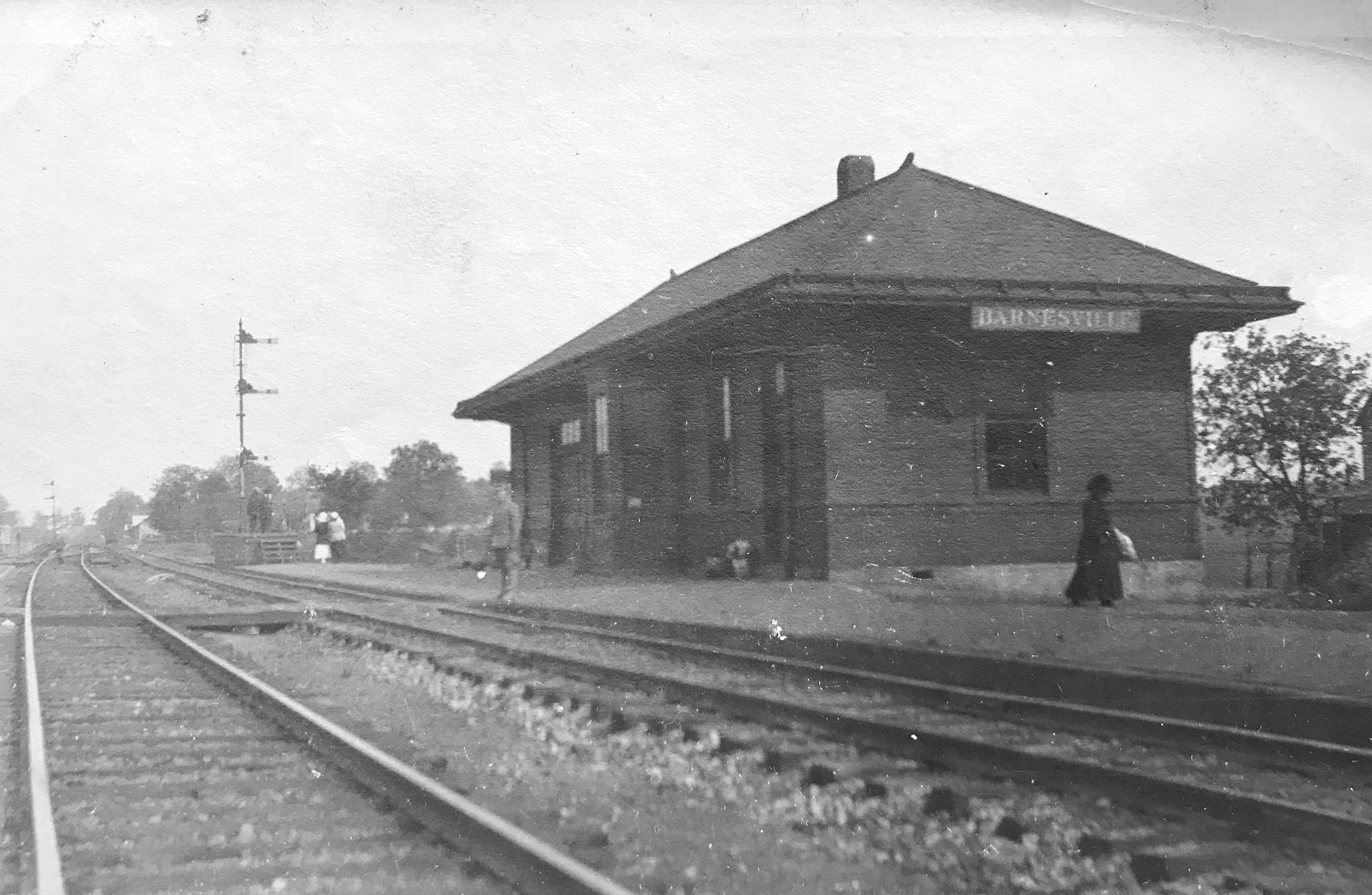
Barnesville (Sellman’s Depot”) Train Station. Photo by Lewis Reed, 1912.
BARNESVILLE MARC STATION (NOW): Built about 1930 as the first metering station for the Washington area gas supply, this building was saved from imminent destruction by concerned citizens dedicated to both the preservation of the visible past and revitalization of the railroad. On February 16, 1977 the historic metering station owned by the Washington Gas Light Company traveled 23 miles by road from Rockville to begin a new existence as the Barnesville railroad station. The squarish little structure had a makeover after the move. It was painted inside and out and and a wide overhanging roof was added just below the original roof line, giving the building more an authentic “train station” look, and it was re-dedicated on October 10, 1977. Snuggled up against the woods, surrounded by trees and shrubbery in a rural area just south of Barnesville on Route 109 (Beallsville Road), the station today is a pretty sight.

The metering station installed at Sellman station by the tracks which today serves as the Barnesville (MARC) Station. It was moved here from Rockville in 1977 for preservation. Image from Wikimedia Commons.
Source: The Montgomery County Story Newsletter, Vol. 37, No.1, February 1994. “Train Stations and Suburban Development Along the Old Baltimore and Ohio Railroad” by Jo Beck
Books
![]()
Related Resources


Copyright Notice

Reed Brothers Dodge History (1915-2012) by Jeanne Gartner is licensed under a Creative Commons Attribution-NonCommercial 3.0 Unported License.

Recent Comments