
Then & Now: Clopper Grist Mill
This post is a continuation of a series of “Then & Now” images that will show photographs of buildings, street scenes, and other historical locales from Lewis Reed’s Photo Collection alongside photographs of how they appear today. Taken approximately 109 years apart, these photos show the Clopper Grist Mill then and now.
Clopper Mill (THEN): Francis Cassatt Clopper bought this mill and 541 acres in 1810, but the earliest mention of a mill on this site dates back to 1777. Clopper’s mill was a square, three-story grist mill, with basement and first floor levels made of local field stone and a third story of brick. The mill was destroyed by a fire in 1947.
On April 15, 1865 Clopper Mill became part of national history when would-be assassin of the Vice President of the United States, George Atzerodt, spent the night there while fleeing from Washington D.C. after the assassination of President Lincoln. George was part of the gang assembled by John Wilkes Booth to eliminate the heads of the U.S. government. He was supposed to kill Vice President Johnson at the Willard Hotel at the same time as Booth assassinated the President. But Atzerodt ran out of courage and instead made his way to Germantown.

Clopper Grist Mill. Photo by Lewis Reed, ca. 1910
Clopper Mill (NOW): The ruins of this large brick and stone mill stand on the west bank of Great Seneca Creek, just south of Clopper Road near the intersection of Warring Station Road. The property was acquired by the State in 1955 as part of Seneca Creek State Park.

Clopper’s Mill Ruins today.
Then & Now: State of Pennsylvania Monument (Gettysburg)
In this “Then & Now” feature, I have combined one of Lewis Reed’s original photograph’s for “then” and matched it with a corresponding contemporary shot for “now”. The Pennsylvania State Memorial is a monument in Gettysburg National Military Park that commemorates the 34,530 Pennsylvania soldiers who fought in the July 1 to 3, 1863 Battle of Gettysburg during the American Civil War. These photos show the same view taken about 109 years apart.
State of Pennsylvania Monument (THEN): This rare photograph was taken by Lewis Reed of the State of Pennsylvania Monument while under construction. Completed in 1914, it is the largest of the state monuments on the Gettysburg Battlefield. Taken approximately 109 years apart, these photos show the State of Pennsylvania Monument then and now.

State of Pennsylvania Monument Under Construction, ca. 1910. Photo by Lewis Reed
State of Pennsylvania Monument (NOW): The State of Pennsylvania Monument (at 110 feet tall) incorporates individual sculptures commemorating the six Keystone State generals who fought at Gettysburg — plus President Abraham Lincoln and Governor Andrew Curtain — and 90 bronze plaques emblazoned with the names of each of the 34,530 Pennsylvanians who fought in the battle. It cost $240,000 to build in the early 1900s, or almost $6 million in 2018.

State of Pennsylvania Monument as it is today.
Source: Wikipedia
Then & Now: Rockville Fair Harness Racing
The black and white photographs of the Rockville Fair harness races below were taken by Lewis Reed in 1910. The photographs were from the first incarnation of the Fair, held by the Montgomery County Agricultural Society (1846-1932) in Rockville and often known simply as the “Rockville Fair.” For this “Then & Now” feature, I have combined Lewis Reed’s original photographs for “then” and matched it with a corresponding contemporary shot for “now” to see the difference 109 years can make.
Rockville Fair Dirt Track Oval (THEN): Like many fairgrounds, the Rockville Fairgrounds included an oval track. Fairground race tracks, typically one-mile or half-mile dirt racing ovals with wide, sweeping curves and grandstands for spectators, were easily adapted for bicycles, harness racing, and the sport of car racing. Harness racing was one of the main attractions, but after the introduction of the automobile in the early 20th century, car races took over. The fairgrounds were just outside Rockville, where Richard Montgomery High School is today.

Rockville drew huge crowds for harness races. Photo by Lewis Reed, circa 1910

Harness race at the Rockville Fair, circa 1910. All those throngs of people had plenty to see. Photo by Lewis Reed
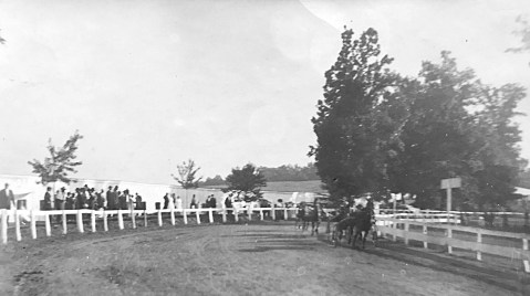
Harness racers rounding the bend on the racetrack, Rockville Fairground circa 1910. Photo by Lewis Reed

Bend on the harness racetrack, Rockville Fairground circa 1910. Photo by Lewis Reed
Rockville Fair Dirt Track Oval (NOW): In 1946, after the construction of Richard Montgomery High School, the old oval race track became a football field and stadium.

RMHS football field and stadium
Then & Now: Thomas & Co. Cannery in Gaithersburg
“Then and Now” photos are an excellent way to explore the passage of time. In this special post, I have combined one of Lewis Reed’s original photograph’s for “then” and matched it with a corresponding contemporary shot for “now”. Taken approximately 100 years apart, these photos show the Thomas and Company Cannery in Gaithersburg, then and now.
Thomas & Company Cannery (THEN): The largest and longest-lived cannery in Montgomery County, the Thomas and Company Cannery operated from 1917 until 1962. While Baltimore had been the center of the canning industry in the 19th century, the outbreak of World War I created a need to rationalize. Frank and Clyde Thomas were leaders in the 20th century canning industry in Maryland. In 1917, the Thomas family opened a cannery in Gaithersburg, the first in Montgomery County. The factory was the focus of local industry and economy, providing an important market for farmers, and employment for local migrant workers.
The factory canned peas, pumpkin and corn, supplied both the local retail market and the war effort during WW I and II. During the war years, the cannery expanded operations and functioned on a three shift schedule to provide vegetables for shipment to troops. After the war, the cannery continued to produce vegetables under the brand names MY-T-NICE, EVER-GOOD, BARBARA FRITCHIE and ON-TOP corn, peas and succotash.
Built along the B & O Railroad to facilitate shipping, the brick cannery had three main parts: the central processing station, the shipping section and boiler plant. The cannery was designated a Gaithersburg landmark in 1987.

Circa 1917 photo taken behind the Thomas and Company Cannery in Gaithersburg. The Cannery was the first and largest vegetable cannery in Montgomery County. It closed in 1963 after fire damage and lay empty until its recent restoration. Photo by Lewis Reed.

Thomas & Company Cannery (NOW): The building saw various uses after the closing of the Cannery, but then lay empty until its recent restoration for office and commercial use.

Source: Maryland Historical Trust
Then & Now: Cherry Blossoms on the Tidal Basin
Time passes, but the cherry blossoms always come back. Seeing the cherry blossoms is a time-honored D.C. tradition that dates back to 1912, when Tokyo gifted 3,020 cherry trees to the U.S. in an act of friendship. While many of the original trees have been replaced, the Tidal Basin’s beauty has persisted for more than a century. Each spring, more than 1.5 million visitors descend upon Washington, D.C. each year to admire the 3,000-plus trees. The three-week-long National Cherry Blossom Festival, which runs from March 20 – April 14, 2019, is full of events that honor both American and Japanese cultures and represents a close bond forged between the two countries that began with Tokyo Mayor Yukio Ozaki’s gift of the trees back in 1912.
Here’s a great “then and now” comparison shot of the Cherry Blossoms on the Tidal Basin in Washington, D.C. from the 1930s and 2019.
Cherry Blossoms on the Tidal Basin (THEN): From Lewis Reed’s collection of photographs. Cherry blossoms in bloom along the Tidal Basin, circa 1930s with my mother, Mary Jane (Reed) Gartner.

Cherry blossoms in bloom along the Tidal Basin with my mother, Mary Jane (Reed) Gartner. Photo by Lewis Reed, ca. 1930s
Cherry Blossoms on the Tidal Basin (NOW): The “now” photo is a google image of approximately the same location… some 80 years later. According to the National Park Service, the 2019 cherry blossom peak bloom period began on April 1. The best viewing of the cherry blossom trees typically lasts four to seven days after peak bloom begins, but the blossoms can last for up to two weeks under ideal conditions.

Cherry blossoms in bloom along the Tidal Basin today.
Fun facts about Washington, DC’s cherry blossoms
- The first donation of 2,000 trees, received in 1910, was burned on orders from President William Howard Taft. Insects and disease had infested the gift, but after hearing about the plight of the first batch, the Japanese mayor sent another 3,020 trees to DC two years later.
- The first two trees were planted on the north bank of Tidal Basin in March 1912, and they still stand today. You can see them at the end of 17th Street Southwest, marked by a large plaque.
- It’s against the law to pick the cherry blossoms in Washington DC. While there aren’t any subtle wire fences or stern security guards like in a museum, any attempts to create your own corsage may very well land you a fine.
- The majority of the cherry blossom trees around the Tidal Basin are of the Yoshino variety. But another species, the Kwanzan, usually blooms two weeks after the Yoshino trees, giving visitors a second chance to catch the blossoms.
- The average lifespan of a cherry blossom tree is only 20 to 30 years, but nearly 100 of the original trees from 1912 still thrive at the Tidal Basin due to the maintenance of the National Park Service.
- No, they’re not all from 1912, reinforcements are sometimes necessary. New trees have been regularly planted, including in 1965, the late 1980s, 1999 and from 2002 to 2006, according to the NPS.
Books
![]()
Related Resources


Copyright Notice

Reed Brothers Dodge History (1915-2012) by Jeanne Gartner is licensed under a Creative Commons Attribution-NonCommercial 3.0 Unported License.

Recent Comments