
Reed Photo Collection: Early 20th Century Motorcycles
Motorcycles have evolved in countless ways since their emergence near the beginning of the 20th century. In the early years of the 20th century, motorcycles and automobiles were competing for the same audience. Most people traveled either on or behind a horse, while the more adventurous were fascinated by those new-fangled bicycle things. So anything with a motor represented a giant step forward.
Take a step back in time with this glimpse into an almost forgotten era of Montgomery County history in the early 20th century… the motorcycle era. These photographs taken by Lewis Reed span a period from roughly the early 1900s up until about the late 1920s.

Lewis Reed sitting on his Harley Davidson circa 1915 somewhere outside Frederick, Maryland.
Lewis Reed was not only passionate about automobiles, he also enjoyed riding motorcycles. At the turn of the century, before cars were even around, Lewis Reed traveled up and down the East Coast on his motorcycle with his brother, Edgar, and a group of friends. In the early days of motorcycling, propriety dictated that a gentleman be presentable when he went out for a spin, and since tweed suits were the standard countryside uniform of the the late-nineteenth century, so it was for motorcyclists as well. Jodhpurs and full-length boots derived from horseback riding and jackets with a cut consistent with hunting and other kinds of sports were adapted to the new pursuit of motorcycle riding.
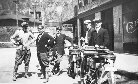
Above, Lewis Reed stands with his camera at far left. The photo was taken 1914 in Harper’s Ferry, West Virginia. The wooden frame Victorian-style train station dating from 1889 can be seen in the background.
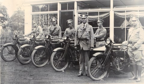
This photograph is the first known photograph of the entire Montgomery County Police Force. Photo taken by Lewis Reed on July 4, 1922.
Montgomery County Mounted Police
By the early 1920’s, the motorcycle had proven itself to be a rugged, reliable, and economical means of transportation. No one benefited from this more than law enforcement agencies. State and local police departments quickly adopted the new machines into their arsenal, allowing patrolmen to more skillfully navigate city streets and venture farther into rural areas.
Posing in front of Reed Brothers Dodge on July 4, 1922 Chief Charles Cooley, center, and his men of the first mounted unit of the Montgomery County Police Force, were on their first day of duty. For several years, since there was no police station, the officers would meet for “roll call” on the steps of the Red Brick Courthouse in Rockville at 2:00 p.m. every day to let each other know they were alive and well. Chief Cooley was given the privilege of a Model T Ford. The chief was paid $1,800 a year (the chief now gets $112,564) while the officers got $1,500. Each of the officers was issued a Harley-Davidson motorcycle, a .38 Smith & Wesson handgun, a black jack, law book and was allotted $300.00 a year for the upkeep of their motorcycle.
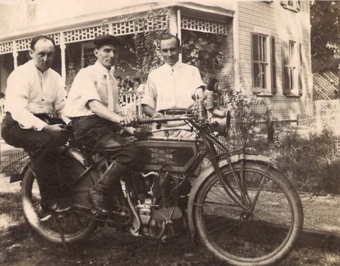
Grafton Reed, Bernie Hanshew, and Lewis Reed (standing)
Have you ever come across a picture that you had to look at twice just to make sure you were not crazy? Well I have… and the photo above is one of them. When I came across this photograph in Lewis Reed’s album, I had to look at it several times to make sure I was not “seeing things”. There is something surprising in this photograph, and when I finally figured out what it was, it put a big smile on my face.
Can you spot the unusual object in this photo?
OK, give up?

It’s a Doll!

Edgar Reed in sidecar, ca. 1914. Photo by Lewis Reed
Once motorcycles were established in the marketplace, various accessory items were developed to accommodate a larger audience for the product. The sidecar, a one-wheeled passenger compartment that was attached to the main frame of the motorcycle, was perhaps the most visible accessory. The sidecar expanded the number of passengers that could be driven and also improved the stability of the vehicle.
This is a photograph taken by Lewis Reed of an Indian motorcycle with his brother, Edgar, seated in the sidecar. From what I’ve been able to research, I believe it’s a 1914 Indian. The handle bars on a 1913 had no cross bar, the 1914 model had a cross bar that can be seen on this one. The tool box was mounted on the rear of the carrier in 1913 and moved to the top of the fuel tank in 1914.

1914-1915 Harley Davidson. Photo taken on Park Street in Rockville by Lewis Reed
Riders wore gauntlet gloves along with their full-length boots to keep the wind out, as well as provide a little extra skin protection should they go down. A less protective addition to the motorcycling wardrobe was the flat cap.
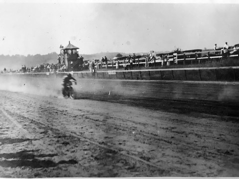
A motorcycle racer rips down an unknown racetrack kicking up dust in his wake. Photo by Lewis Reed, ca. 1915
Lewis Reed Captures the Thrill of Motorcycle Racing in 1915
In the first years of the twentieth century, companies like Harley-Davidson and Indian began producing motorcycles for the general public. Although there is not an exact date of the first motorcycle race, you can be sure that as soon as there were two motorcycles on the road, there was racing. As more and more motorcycle manufactures started popping up across the U.S., motorcycle racing started making it’s way to more official venues. The earliest races were held on fairground dirt tracks used for horse racing. On short tracks, typical of county fairs, the most valuable driving technique involved the infamous “pendulum skid,” with riders taking the curves much as automobile drifters do today (but with two wheels fewer, to add to the excitement).
The photograph above taken by Lewis Reed shows an unknown racer at a fairground raceway in the early 1900s. In the teens, motorcycle racing on dirt tracks throughout the country, was one of the most popular spectator sports. Despite the danger to both racers and spectators, the motorcycle races became very popular and drew large crowds of spectators. Motorcycle racing continued until just after World War 1, when the focus shifted to automobile racing.
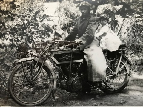
Unknown lady and toddler posing on a 1913-1914 Excelsior motorcycle. Photo by Lewis Reed
Back in the early part of the last century when the motorcycle was still new and a novelty, it was often used for Kodak moments. In the photo above, the toddler’s sporty little cap and goggles make the image. Just imagine how excited she must have been to sit on that big machine. The motorcycle seems to be well equipped with extras including: a headlamp, a handlebar-mounted Klaxon horn, and a well padded passenger seat on the back.

Lady & toddler on Harley Davidson motorcycle. Photo by Lewis Reed, circa 1914

Motorcyclists in front of Greenawalt Drug Store in Frederick, Maryland. Photo by Lewis Reed, circa 1915
Things look pretty quiet in front of Greenawalt Drug Store on Market Street in Frederick, Maryland on this day some 100 years ago. In the early days, motorcyclists were more likely to wear a tie and sporty little cap than the leather of today.

Lewis Reed is airing up the rear tire of his Harley Davidson with an old-style hand pump, 1915.
Motorcycle repair shops were nearly nonexistent in the early 1900s, so many motorcyclists had to learn to fix their own machines wherever they broke down. Early motorcycles carried a tool box mounted on the rear luggage carrier, or on the top of the fuel tank. Hand air pumps were also carried in case the rider had a flat tire along the way.

Repairing a flat tire on the side of the road. Photo by Lewis Reed
If you look closely at this photo, you can see bicycle pedals on the motorcycle. Most early motorcycles were equipped with pedals so that an unlucky rider with a failed engine could still get home. They were also handy for getting a little extra uphill push and for starting the machine.

Edgar Reed and unknown lady on Excelsior motorcycle. Photo by Lewis Reed, ca. 1914
The early days of motorcycle riding was an expensive joy and pursued mostly by wealthy men. Instead of having a motorcycle as a source of transportation, gentlemen of the days oftentimes used it to spice up their sunny weekends and impress ladies. Outfit relevance dictated a gentleman to be presentable and neat, so when going for a spin, Edgar Reed is wearing a leather jacket, full-length boots, necktie and sporty cap with goggles.

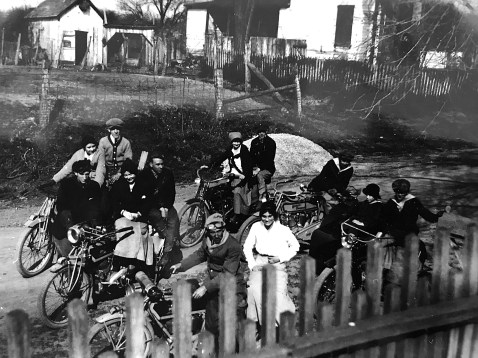
Edgar Reed (rider second from left) and Lewis Reed standing behind him (others unidentified). On Park Street in Rockville, ca. 1912
Early motorcyclists were often pictured in riding groups. From its beginnings, motorcycling developed very much as a social activity. Lewis and Edgar Reed, along with brother-in-law Bernard Hanshew, began their riding adventures with a group of friends from the Park Avenue community in Rockville in the early 1900s.

Eleanora Reed, and Lewis Reed’s sisters Geneva and Eva posing on Excelsior motorcycles, 1912. (Note they are all sitting “side-saddle” as true ladies of the time would have been expected to do). Photo by Lewis Reed
While women have been enthusiastic bikers ever since motorcycles were invented, they have had to push back against deeply ingrained attitudes. Women in the first half of the 20th century were expected to dress fashionably and conservatively, and above all, remain ladylike. Sitting astride a motorcycle was considered uncouth: the same as riding a horse with a leg on each side.

Motorcyclists on Rt 118 in Darnestown, Maryland. Photo by Lewis Reed, ca. 1914

Motorcyclists on Rt 118 in Darnestown, Maryland. Photo by Lewis Reed, ca. 1914
Motorcyclists on Rt 118 in Darnestown, Maryland. Photo by Lewis Reed, ca. 1914

Future biker on the right. Photo by Lewis Reed, ca. 1914
Early 1900s Photograph Taken at Stoneyhurst Quarries

Edgar Reed (front) and unidentified companions pose for a photograph at Stoneyhurst Quarries, Bethesda, Maryland. Photo by Lewis Reed, ca. early 1900s
The Stoneyhurst Quarry on River Road in Bethesda Maryland has been supplying stones since the 1920s for some of the great landmarks of Washington, DC, including the National Cathedral. The quarry was first opened in 1924 by the aptly named Lilly Stone. She was a widow in her 60s at the time and her family had owned multiple quarries but were also farmers. When the farm was busy, the quarries lay dormant. However after World War I, the family needed money after their farm had been destroyed in a disastrous fire. She once said that her father had told her, “Lilly, if you are ever in need, open the quarries.” And thus, she decided to open the quarry business on a full-time basis and personally oversaw operations until the mid 1950s.
Lilly didn’t hand the reigns over to her son Dunbar until she was in her mid 90’s! Quite an accomplishment for anyone, but also considering the culture of the times, a strong woman operating a large, notable business was quite unusual. She was the only female quarrier in the country that anyone knew of and quite an interesting character to say the least. Described as a “feisty lady” she once was arrested for speeding in a truck and hitting the officer on the head with a cane when she was ticketed.
During her spare time, Lilly researched Maryland’s historical roots and helped establish the Montgomery County Historical Society. She was also instrumental in organizing the Maryland State Historical Society and even designed Montgomery County’s original flag.
Source of Information: Montgomery History
Happy Valentine’s (and Ferris Wheel) Day!

Ferris Wheel at Rockville Fair, circa 1920s. Photo by Lewis Reed
Did you know that February 14th is not only Valentine’s Day, but also Ferris Wheel Day? This unofficial national holiday is held on this day to honor the birth of the inventor of the Ferris Wheel, George Washington Gale Ferris, Jr. What better way to celebrate Ferris Wheel Day than enjoying this old photograph of the Ferris Wheel taken at the Rockville Fairgrounds, courtesy of Lewis Reed. The fairgrounds were just outside Rockville, about where Richard Montgomery High School is today. The Fair lasted four days, from August 21st to the 24th, and drew visitors from local counties, Washington, and Baltimore.
For the singles and the “enough already with the Valentines”, here is your perfect alternative excuse. Go wish all your friends and family a Happy Ferris Wheel Day!
1915 Street Scene in Middlesex VA

Motorcyclists and cars getting gas at a curbside pump at Middlesex Ford Agency, circa 1915. Photo by Lewis Reed
It is always interesting to see photos from days gone past. The interesting street scene above was taken by Lewis Reed in Middlesex, Virginia. All of the cars in the view are late model vehicles. The Middlesex Garage, which appears to be a Ford Agency that advertises gasoline, oils and lubricants for sale, is also visible. A closer look reveals the price of gasoline as 15 cents. Also visible in the photo are trolley tracks running down the middle of the dirt road.
Below are motorcyclists posing on the street in Middlesex. Edgar Reed is shown on the left on his Excelsior motorcycle.

Motorcyclists in Middlesex VA, circa 1915. Edgar Reed is on the left. Photo by Lewis Reed
Middlesex County is located on the Middle Peninsula in the U.S. state of Virginia. Middlesex has remained largely rural over the years with farming, forestry, fin and shell fishing and tourism providing the principal elements of its economic base. Its geographical location has helped it to retain its rural character while also making it the perfect place to recapture childhood memories of summer days spent on a boat, catching crabs and water skiing.
Dirt Roads of Rural Montgomery County
In the early 19th century, most roads were dreadful. Rural roads were often hard and bumpy; in warm months, they were dry and dusty, while in the spring they were wet and muddy. In winter, they could be covered with ice or snow. Most roads were so narrow that if two buggies met, one might be forced into a ditch along the side of the road. In those days there were few bridges, so drivers simply drove their wagons through rivers and streams.
The popularity of the car coincided with the improvement of public roads around Rockville. Rockville Pike’s reputation as “one of the worst pieces of main highway in the state” helped initiate Maryland’s Good Roads Movement. Responding to citizen demands, the newly created State Roads Commission incorporated the Pike into the state highway system. By 1929, when Montgomery County residents owned 13,000 cars, the Pike and Montgomery Avenue had been paved, but less traveled Veirs Mill Road remained a narrow dirt road for decades. By the end of 1935, the highway was paved as a macadam road.
Veirs Mill Road
History: Veirs Mill Road is named for a grist and sawmill on Rock Creek built by Samuel Clark Veirs in 1838 and operated by his family until 1924. This mill drew business from Rockville and Mitchell’s Crossroads, which later became Wheaton, along its namesake road. Below, two images of Viers Mill Road, c. 1911, showing deep ruts in the surface. Wagon wheels and tires of the time were very thin, and would sink straight into ruts, sometimes getting stuck.
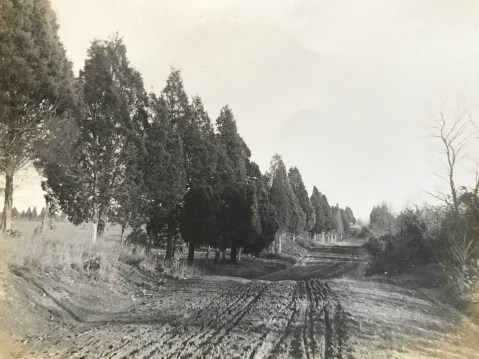
Veirs Mill Road looking east prior to paving. Photo by Lewis Reed, 1911
Stalled in the mud… “Although he put on the entire 20-horsepower of his machine and called in assistance of several neighbors, it was not until shovels and crowbars had been procured to move his car… he was able to resume his journey. This experience not only caused more than an hour’s delay in reaching the city but the wear and tear on himself, those who rendered assistance, and incidentally, the machine. Thus, at least two months of the life of a $3,000 auto was spent in simply traversing a short stretch of roadway.

Veirs Mill Road looking east prior to paving. Photo by Lewis Reed, 1911
Montgomery County had 790 miles of unimproved dirt roads in 1899 and only 45 miles of stone, gravel, or macadam roads. The only good roads in the County were the turnpikes in the northeast; they accounted for all but 8 miles of the improved highways. The Union Turnpike Company operated from the District line at Silver Spring to Brookeville, from Olney to Ashton,and from Sandy Spring to Glenmont. The Washington, Colesville, and Ashton Turnpike Company maintained Colesville Road from Ashton to Silver Spring.
Darnestown Road
Lewis Reed grew up in Darnestown, so many of his streetscapes depict that specific region of Montgomery County.
History: The Darnestown area, which was located at the intersection of Darnestown and Seneca Roads, was settled in the 1750s. Darnestown Road (or Route 28) was an old Indian trail and is recognized as one of the oldest roads in Montgomery County, Maryland. During the 1870s through 1900, Darnestown was a thriving business hub due to its trade linked to the canal. Darnestown became an important place for commerce in the area. Seneca Road led to a sandstone mill and the C&O canal at Seneca Village. From Darnestown one could travel either by stagecoach along Darnestown Road or board a packet boat on the canal at Seneca.
After the Civil War, Darnestown experienced an economic downturn due to the increased popularity of the railroad, which bypassed the area. The mill business decreased and some farmers tried their hand at tobacco farming. This proved to be unprofitable for most and many people left the area. It wasn’t until World War II that Darnestown began to grow and prosper again.
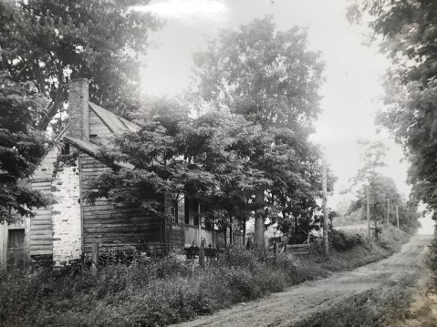
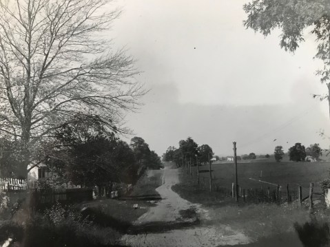
Route 28, Darnestown Road 1907 – Martin Thompson House, owned by Lewis Reed’s maternal grandfather.
Route 28, in Darnestown is depicted in this photo before paving. What is now Route 28 is one of the earliest roads in the county, and was one of the main ways farmers in Poolesville, Darnestown, Dickerson, and Barnesville reached the courthouse in Rockville.
Darnestown. Photo by Lewis Reed
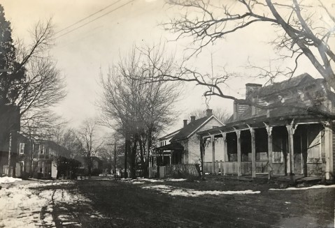
Darnestown, Rt 28. Photo by Lewis Reed
At the time the photo above was taken, the Griffith family owned the house and lot in the foreground. The frame and log house may have been built as early as the 1850s; by 1863 it was used as a house and store by Samuel Fisher. Fisher eventually sold the property to Ulysses Griffith and James Windsor, who also used it as a store. Griffith and Windsor continued as partners for ten years, until Windsor built his own store and house at the southwest corner of Seneca and Darnestown roads.

Darnestown along Rt 28. Photo by Lewis Reed

Darnestown. Photo by Lewis Reed

Darnestown dirt road. Photo by Lewis Reed
Seneca Road
History: The first segment of MD 112 was a 1-mile concrete road south from MD 28 in Darnestown that was built in 1923.The highway was extended southwest to the hamlet of Seneca just east of Seneca Creek in 1929 and 1930. MD 112’s western terminus was originally a short distance west of MD 190; the highway was truncated at MD 190 between 1975 and 1977.

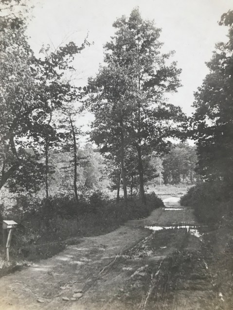
Seneca Road. Note the horse and buggy traveling up the road in the distance. A motorcycle (perhaps Lewis Reed’s) sits on the side of the road near the dead tree. Photo by Lewis Reed
Norbeck Road (Rt, 28)
Route 28 has existed since before the Civil War, and it remained a mud path for years into the automobile age.

Norbeck Road, near Rockville. In the far distance are two pedestrians; in the nearer distance a one- or two-person buggy is traveling away from the camera. Photo by Lewis Reed

Horse and Buggy on Hunting Hill Rockville. Photo by Lewis Reed
Hunting Hill and Quince Orchard, the first of eight small communities along Route 28 west of Rockville, have been transformed largely because of a single building on a historic estate. In 1942, Otis Beall Kent purchased the estate of Frederick A. Tschisfely, a Washington wholesale druggist, and consolidated four farms to make a 1,000-acre farm. He built seven lakes, maintained his own fire department and dreamed of such things as a hydroelectric plant on the property.

Dirt road and bicycle. Photo by Lewis Reed
Cedar Lane Bethesda. Photo by Lewis Reed
Roads to the Future
Rockville Pike’s reputation as “one of the worst pieces of main highway in the state” eventually helped initiate Maryland’s Good Roads Movement, alongside a nationwide initiative to improve America’s roads. Responding to citizen demands, the newly created State Roads Commission incorporated the Rockville Pike into the state highway system.
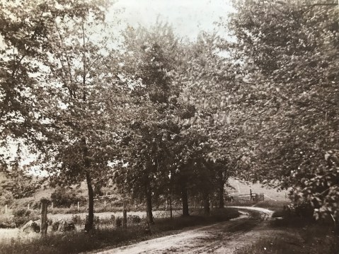
Ironically, Montgomery County would eventually enact legislation to protect some of its rural roads from the type of traffic-conscious expansion that could spoil the natural beauty of the landscape on either side of the drive, as shown in this early 20th century photograph. Photo by Lewis Reed
Books
![]()
Related Resources


Copyright Notice

Reed Brothers Dodge History (1915-2012) by Jeanne Gartner is licensed under a Creative Commons Attribution-NonCommercial 3.0 Unported License.

Recent Comments