
Dirt Roads of Rural Montgomery County
In the early 19th century, most roads were dreadful. Rural roads were often hard and bumpy; in warm months, they were dry and dusty, while in the spring they were wet and muddy. In winter, they could be covered with ice or snow. Most roads were so narrow that if two buggies met, one might be forced into a ditch along the side of the road. In those days there were few bridges, so drivers simply drove their wagons through rivers and streams.
The popularity of the car coincided with the improvement of public roads around Rockville. Rockville Pike’s reputation as “one of the worst pieces of main highway in the state” helped initiate Maryland’s Good Roads Movement. Responding to citizen demands, the newly created State Roads Commission incorporated the Pike into the state highway system. By 1929, when Montgomery County residents owned 13,000 cars, the Pike and Montgomery Avenue had been paved, but less traveled Veirs Mill Road remained a narrow dirt road for decades. By the end of 1935, the highway was paved as a macadam road.
Veirs Mill Road
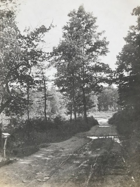
History: Veirs Mill Road is named for a grist and sawmill on Rock Creek built by Samuel Clark Veirs in 1838 and operated by his family until 1924. This mill drew business from Rockville and Mitchell’s Crossroads, which later became Wheaton, along its namesake road. Below, two images of Viers Mill Road, c. 1911, showing deep ruts in the surface. Wagon wheels and tires of the time were very thin, and would sink straight into ruts, sometimes getting stuck.
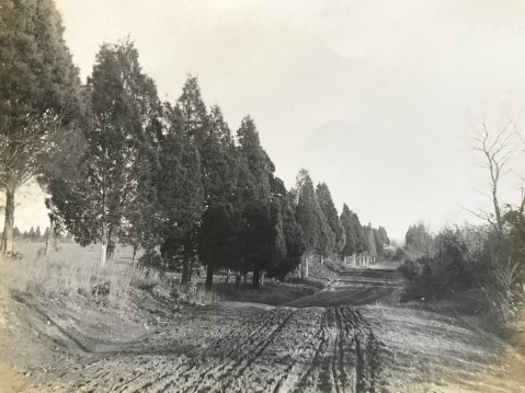
Veirs Mill Road looking east prior to paving. Photo by Lewis Reed, 1911
Stalled in the mud… “Although he put on the entire 20-horsepower of his machine and called in assistance of several neighbors, it was not until shovels and crowbars had been procured to move his car… he was able to resume his journey. This experience not only caused more than an hour’s delay in reaching the city but the wear and tear on himself, those who rendered assistance, and incidentally, the machine. Thus, at least two months of the life of a $3,000 auto was spent in simply traversing a short stretch of roadway.

Veirs Mill Road looking east prior to paving. Photo by Lewis Reed, 1911
Montgomery County had 790 miles of unimproved dirt roads in 1899 and only 45 miles of stone, gravel, or macadam roads. The only good roads in the County were the turnpikes in the northeast; they accounted for all but 8 miles of the improved highways. The Union Turnpike Company operated from the District line at Silver Spring to Brookeville, from Olney to Ashton,and from Sandy Spring to Glenmont. The Washington, Colesville, and Ashton Turnpike Company maintained Colesville Road from Ashton to Silver Spring.
Darnestown Road
Lewis Reed grew up in Darnestown, so many of his streetscapes depict that specific region of Montgomery County.
History: The Darnestown area, which was located at the intersection of Darnestown and Seneca Roads, was settled in the 1750s. Darnestown Road (or Route 28) was an old Indian trail and is recognized as one of the oldest roads in Montgomery County, Maryland. During the 1870s through 1900, Darnestown was a thriving business hub due to its trade linked to the canal. Darnestown became an important place for commerce in the area. Seneca Road led to a sandstone mill and the C&O canal at Seneca Village. From Darnestown one could travel either by stagecoach along Darnestown Road or board a packet boat on the canal at Seneca.
After the Civil War, Darnestown experienced an economic downturn due to the increased popularity of the railroad, which bypassed the area. The mill business decreased and some farmers tried their hand at tobacco farming. This proved to be unprofitable for most and many people left the area. It wasn’t until World War II that Darnestown began to grow and prosper again.
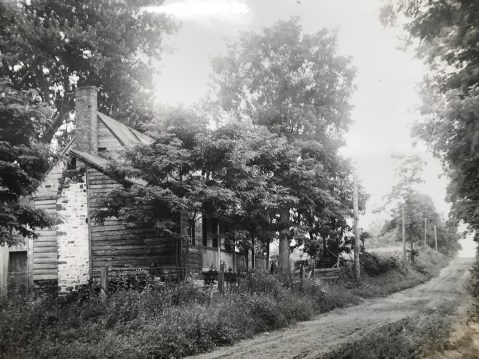
Route 28, Darnestown Road 1907 – Martin Thompson House, owned by Lewis Reed’s maternal grandfather.
Route 28, in Darnestown is depicted in this photo before paving. What is now Route 28 is one of the earliest roads in the county, and was one of the main ways farmers in Poolesville, Darnestown, Dickerson, and Barnesville reached the courthouse in Rockville.
Darnestown. Photo by Lewis Reed
Darnestown, Rt 28. Photo by Lewis Reed
At the time the photo above was taken, the Griffith family owned the house and lot in the foreground. The frame and log house may have been built as early as the 1850s; by 1863 it was used as a house and store by Samuel Fisher. Fisher eventually sold the property to Ulysses Griffith and James Windsor, who also used it as a store. Griffith and Windsor continued as partners for ten years, until Windsor built his own store and house at the southwest corner of Seneca and Darnestown roads.

Darnestown along Rt 28. Photo by Lewis Reed

Darnestown. Photo by Lewis Reed

Darnestown dirt road. Photo by Lewis Reed
Seneca Road
History: The first segment of MD 112 was a 1-mile concrete road south from MD 28 in Darnestown that was built in 1923.The highway was extended southwest to the hamlet of Seneca just east of Seneca Creek in 1929 and 1930. MD 112’s western terminus was originally a short distance west of MD 190; the highway was truncated at MD 190 between 1975 and 1977.

Seneca Road. Note the horse and buggy traveling up the road in the distance. A motorcycle (perhaps Lewis Reed’s) sits on the side of the road near the dead tree. Photo by Lewis Reed
Norbeck Road (Rt, 28)
Route 28 has existed since before the Civil War, and it remained a mud path for years into the automobile age.

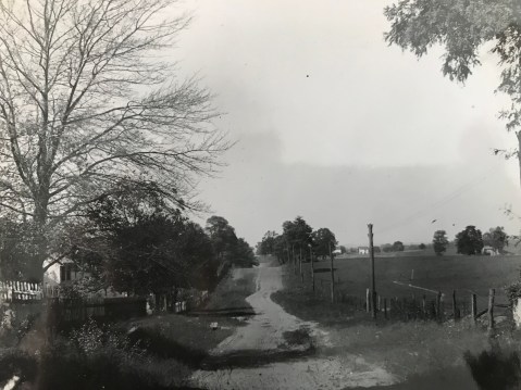
Norbeck Road, near Rockville. In the far distance are two pedestrians; in the nearer distance a one- or two-person buggy is traveling away from the camera. Photo by Lewis Reed

Horse and Buggy on Hunting Hill Rockville. Photo by Lewis Reed
Hunting Hill and Quince Orchard, the first of eight small communities along Route 28 west of Rockville, have been transformed largely because of a single building on a historic estate. In 1942, Otis Beall Kent purchased the estate of Frederick A. Tschisfely, a Washington wholesale druggist, and consolidated four farms to make a 1,000-acre farm. He built seven lakes, maintained his own fire department and dreamed of such things as a hydroelectric plant on the property.

Dirt road and bicycle. Photo by Lewis Reed
Cedar Lane Bethesda. Photo by Lewis Reed
Roads to the Future
Rockville Pike’s reputation as “one of the worst pieces of main highway in the state” eventually helped initiate Maryland’s Good Roads Movement, alongside a nationwide initiative to improve America’s roads. Responding to citizen demands, the newly created State Roads Commission incorporated the Rockville Pike into the state highway system.
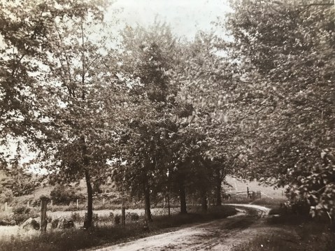
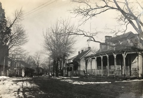
Ironically, Montgomery County would eventually enact legislation to protect some of its rural roads from the type of traffic-conscious expansion that could spoil the natural beauty of the landscape on either side of the drive, as shown in this early 20th century photograph. Photo by Lewis Reed
4 responses to “Dirt Roads of Rural Montgomery County”
Leave a comment
Books
![]()
Recent Comments
| Reed Brothers on Then and Now: Commander Hotel… | |
| Reed Brothers on Then & Now: New Occidental… | |
| Courtney Wells on Then & Now: New Occidental… | |
| Mark Brezler on Then and Now: Commander Hotel… | |
| Reed Brothers on From Chauffeur to Dodge D… | |
| Reed Brothers on 90 Year Brouchure | |
| Anthony Belson on 90 Year Brouchure | |
| Michelle on From Chauffeur to Dodge D… | |
| ptkernan on Snapshots in Time: Reed Brothe… | |
| Reed Brothers on Winter’s Harvest: Ice-Cutting… |
Related Resources


Copyright Notice

Reed Brothers Dodge History (1915-2012) by Jeanne Gartner is licensed under a Creative Commons Attribution-NonCommercial 3.0 Unported License.

Great stuff Jeanne. Thanks!
nice stuff was raised in the area
I really appreciate your photos. I can stare and imagine what those wonderful days musta been like👍 Good day! John
Hello John, Thank you for visiting and your very kind comment. So happy you enjoyed the photos!
My Best Regards,
Jeanne