
1915 Street Scene in Middlesex VA

Motorcyclists and cars getting gas at a curbside pump at Middlesex Ford Agency, circa 1915. Photo by Lewis Reed
It is always interesting to see photos from days gone past. The interesting street scene above was taken by Lewis Reed in Middlesex, Virginia. All of the cars in the view are late model vehicles. The Middlesex Garage, which appears to be a Ford Agency that advertises gasoline, oils and lubricants for sale, is also visible. A closer look reveals the price of gasoline as 15 cents. Also visible in the photo are trolley tracks running down the middle of the dirt road.
Below are motorcyclists posing on the street in Middlesex. Edgar Reed is shown on the left on his Excelsior motorcycle.

Motorcyclists in Middlesex VA, circa 1915. Edgar Reed is on the left. Photo by Lewis Reed
Middlesex County is located on the Middle Peninsula in the U.S. state of Virginia. Middlesex has remained largely rural over the years with farming, forestry, fin and shell fishing and tourism providing the principal elements of its economic base. Its geographical location has helped it to retain its rural character while also making it the perfect place to recapture childhood memories of summer days spent on a boat, catching crabs and water skiing.
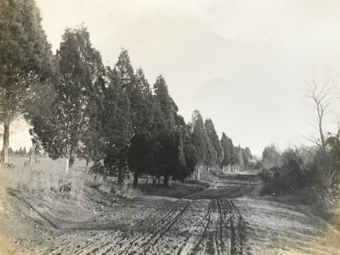
Dirt Roads of Rural Montgomery County
In the early 19th century, most roads were dreadful. Rural roads were often hard and bumpy; in warm months, they were dry and dusty, while in the spring they were wet and muddy. In winter, they could be covered with ice or snow. Most roads were so narrow that if two buggies met, one might be forced into a ditch along the side of the road. In those days there were few bridges, so drivers simply drove their wagons through rivers and streams.
The popularity of the car coincided with the improvement of public roads around Rockville. Rockville Pike’s reputation as “one of the worst pieces of main highway in the state” helped initiate Maryland’s Good Roads Movement. Responding to citizen demands, the newly created State Roads Commission incorporated the Pike into the state highway system. By 1929, when Montgomery County residents owned 13,000 cars, the Pike and Montgomery Avenue had been paved, but less traveled Veirs Mill Road remained a narrow dirt road for decades. By the end of 1935, the highway was paved as a macadam road.
Veirs Mill Road
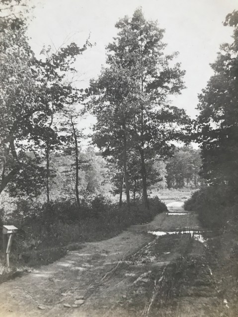
History: Veirs Mill Road is named for a grist and sawmill on Rock Creek built by Samuel Clark Veirs in 1838 and operated by his family until 1924. This mill drew business from Rockville and Mitchell’s Crossroads, which later became Wheaton, along its namesake road. Below, two images of Viers Mill Road, c. 1911, showing deep ruts in the surface. Wagon wheels and tires of the time were very thin, and would sink straight into ruts, sometimes getting stuck.
Veirs Mill Road looking east prior to paving. Photo by Lewis Reed, 1911
Stalled in the mud… “Although he put on the entire 20-horsepower of his machine and called in assistance of several neighbors, it was not until shovels and crowbars had been procured to move his car… he was able to resume his journey. This experience not only caused more than an hour’s delay in reaching the city but the wear and tear on himself, those who rendered assistance, and incidentally, the machine. Thus, at least two months of the life of a $3,000 auto was spent in simply traversing a short stretch of roadway.

Veirs Mill Road looking east prior to paving. Photo by Lewis Reed, 1911
Montgomery County had 790 miles of unimproved dirt roads in 1899 and only 45 miles of stone, gravel, or macadam roads. The only good roads in the County were the turnpikes in the northeast; they accounted for all but 8 miles of the improved highways. The Union Turnpike Company operated from the District line at Silver Spring to Brookeville, from Olney to Ashton,and from Sandy Spring to Glenmont. The Washington, Colesville, and Ashton Turnpike Company maintained Colesville Road from Ashton to Silver Spring.
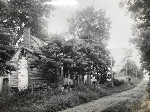
Darnestown Road
Lewis Reed grew up in Darnestown, so many of his streetscapes depict that specific region of Montgomery County.
History: The Darnestown area, which was located at the intersection of Darnestown and Seneca Roads, was settled in the 1750s. Darnestown Road (or Route 28) was an old Indian trail and is recognized as one of the oldest roads in Montgomery County, Maryland. During the 1870s through 1900, Darnestown was a thriving business hub due to its trade linked to the canal. Darnestown became an important place for commerce in the area. Seneca Road led to a sandstone mill and the C&O canal at Seneca Village. From Darnestown one could travel either by stagecoach along Darnestown Road or board a packet boat on the canal at Seneca.
After the Civil War, Darnestown experienced an economic downturn due to the increased popularity of the railroad, which bypassed the area. The mill business decreased and some farmers tried their hand at tobacco farming. This proved to be unprofitable for most and many people left the area. It wasn’t until World War II that Darnestown began to grow and prosper again.
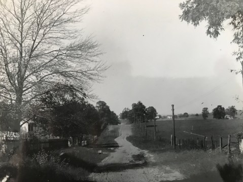
Route 28, Darnestown Road 1907 – Martin Thompson House, owned by Lewis Reed’s maternal grandfather.
Route 28, in Darnestown is depicted in this photo before paving. What is now Route 28 is one of the earliest roads in the county, and was one of the main ways farmers in Poolesville, Darnestown, Dickerson, and Barnesville reached the courthouse in Rockville.
Darnestown. Photo by Lewis Reed
Darnestown, Rt 28. Photo by Lewis Reed
At the time the photo above was taken, the Griffith family owned the house and lot in the foreground. The frame and log house may have been built as early as the 1850s; by 1863 it was used as a house and store by Samuel Fisher. Fisher eventually sold the property to Ulysses Griffith and James Windsor, who also used it as a store. Griffith and Windsor continued as partners for ten years, until Windsor built his own store and house at the southwest corner of Seneca and Darnestown roads.

Darnestown along Rt 28. Photo by Lewis Reed

Darnestown. Photo by Lewis Reed

Darnestown dirt road. Photo by Lewis Reed
Seneca Road
History: The first segment of MD 112 was a 1-mile concrete road south from MD 28 in Darnestown that was built in 1923.The highway was extended southwest to the hamlet of Seneca just east of Seneca Creek in 1929 and 1930. MD 112’s western terminus was originally a short distance west of MD 190; the highway was truncated at MD 190 between 1975 and 1977.

Seneca Road. Note the horse and buggy traveling up the road in the distance. A motorcycle (perhaps Lewis Reed’s) sits on the side of the road near the dead tree. Photo by Lewis Reed
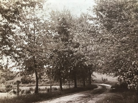
Norbeck Road (Rt, 28)
Route 28 has existed since before the Civil War, and it remained a mud path for years into the automobile age.

Norbeck Road, near Rockville. In the far distance are two pedestrians; in the nearer distance a one- or two-person buggy is traveling away from the camera. Photo by Lewis Reed

Horse and Buggy on Hunting Hill Rockville. Photo by Lewis Reed
Hunting Hill and Quince Orchard, the first of eight small communities along Route 28 west of Rockville, have been transformed largely because of a single building on a historic estate. In 1942, Otis Beall Kent purchased the estate of Frederick A. Tschisfely, a Washington wholesale druggist, and consolidated four farms to make a 1,000-acre farm. He built seven lakes, maintained his own fire department and dreamed of such things as a hydroelectric plant on the property.

Dirt road and bicycle. Photo by Lewis Reed
Cedar Lane Bethesda. Photo by Lewis Reed
Roads to the Future
Rockville Pike’s reputation as “one of the worst pieces of main highway in the state” eventually helped initiate Maryland’s Good Roads Movement, alongside a nationwide initiative to improve America’s roads. Responding to citizen demands, the newly created State Roads Commission incorporated the Rockville Pike into the state highway system.
Ironically, Montgomery County would eventually enact legislation to protect some of its rural roads from the type of traffic-conscious expansion that could spoil the natural beauty of the landscape on either side of the drive, as shown in this early 20th century photograph. Photo by Lewis Reed
Then & Now: Point of Rocks Station
Looking at old photographs is like peering through an open window back into history. Not only do they give you a sense of wonder from traveling back in time, but also a staggering feeling of awe from seeing just how much things have changed. For this post, I have used one of Lewis Reed’s original photographs for “then” and a Google stock image for “now”.

Point of Rocks Station. Photo by Lewis Reed, ca. 1911.
Point of Rocks Station (THEN): Point of Rocks is the location of an important railroad junction and the site of one of the most picturesque and best known of the historic stations of the former Baltimore and Ohio Railroad. At this junction, the ex-B&O Old Main Line from Baltimore, one of the oldest lines in the country, and the ex-B&O Metropolitan Branch from Washington, D.C., opened in 1873, come together and continue west as one line to Cumberland, Pittsburgh, and Ohio. A little known fact is that the station was struck by lightning in the late afternoon of June 27, 1931 and gutted. We can be thankful that the B&O ordered its full restoration.
Point of Rocks Station (NOW):

Point of Rocks Station today.
Montgomery History Online Exhibit: Montgomery County 1900-1930: Through the Lens of Lewis Reed

Opened January 7, 2020
Curated by Jeanne Gartner and Sarah Hedlund
Discover Montgomery County in the early 20th century through the remarkable photography of Lewis Reed, founder of Reed Brothers Dodge. An avid photographer and pioneering automobile dealer, Reed documented the region during his motorcycle journeys across Maryland, capturing the transformation of transportation, daily life, recreation, and community scenes from 1900 to 1930. His photographs offer an intimate window into the people, places, and moments that defined the county and shaped broader American history.
This online exhibition was carefully curated by Jeanne Gartner, granddaughter of Lewis Reed and co-owner of Reed Brothers Dodge, in collaboration with Sarah Hedlund, Archivist and Librarian at Montgomery History. Jeanne’s curatorial vision was instrumental in organizing these photographs into thematic galleries that illuminate Reed’s artistic legacy and documentary purpose, from the evolution of transportation and leisure pursuits to innovative photographic techniques and local economic growth.
Together, these images form a vital portrait of Montgomery County over a century ago, revealing Lewis Reed’s deep appreciation for his community and his enduring commitment to preserving its history for future generations.
View the full exhibition online: https://sites.google.com/view/lewis-reed-photography/home
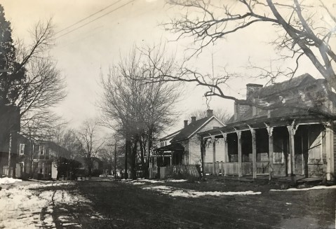
Rare Images of Early Rockville from Lewis Reed’s Collection

This photograph was marked only “Rockville.” Note that the sidewalks are board planks elevated from street level. Photo by Lewis Reed ca, 1912
What makes Rockville such an interesting place? It’s interesting history! Old photos have an amazing way of showing us what life was like years ago and depicting how our communities once looked. You might not realize how much things have changed until you look back and see what it looked like in the past.
A bit of Rockville history: More than 250 years ago, land grants to European settlers formed the nucleus for today’s Rockville, Maryland. By the 1750s local farmers were transporting tobacco to market in Georgetown down a road formerly used by Indians. The tiny settlement was designated as the seat of the new Montgomery County in 1776. Known as Rockville by 1803, the town’s life centered on Courthouse activity. More homes and shops were built, and the town of nearly 600 was incorporated in 1860. The dynamics that created Rockville in the 18th and 19th centuries are still the same ones attracting newcomers today: the presence of county government, a favorable location close to the nation’s capital, converging transportation routes that bring people here, and identity as an independent municipality.
Take a journey back in time through the lens of Lewis Reed and see what Rockville looked like more than one hundred years ago. As always, click the photos to get a better look.

North side of East Montgomery Avenue near the courthouse, ca. 1914. Note the trolley car on the left. Photo by Lewis Reed
Shops sold groceries, baked goods, sewing machines, hats, lumber, and hardware. Families lived above their stores, renting rooms to others.

Court House Triangle. The large white house behind the Confederate Statue is the Hicks House. The Montgomery House Hotel is to the right of the Hicks House, just out of the image. Photo by Lewis Reed, 1914
On September 28, 1917 a draft for World War I began and the first 40 men reported for duty at the Montgomery County Court House in Rockville, Maryland. In the photograph below, cars are parked around the court house during the speech-making in the court room to drafted men. Montgomery County’s first recruits left Rockville by train for Camp Meade, Maryland on this same day. They each received a package of smoking tobacco and a rousing send-off from two thousand people after speeches at the courthouse, dinner at the Montgomery House Hotel, and a parade to the depot. About 160 Rockville men served in the eighteen-month war. One of those men was Rockville resident, Edgar Reed. Edgar was fortunate enough to survive World War I and to settle back in Rockville and enjoy a successful life and career in the automobile business.

Montgomery County Court House. Photo by Lewis Reed, 1917.
Notice that most of the cars in the above photo have two license plates: at this time, you needed a separate tag to drive a car in the District of Columbia. There is also horse dung in the dirt road (E. Montgomery Avenue), suggesting buggies had been by recently as well. Barely visible in the background left is the Maryland National Bank building, which was demolished during urban renewal in the late 1960s.

Suburban Electrical Company on Montgomery Avenue in Rockville. Photo by Lewis Reed, ca.1914
The upper story of this building was the living quarters of Mr and Mrs B. F. Hicks. The building was later acquired by W. Valentine Wilson, who tore it down and replaced is with the “SECO” for Mr Wilson’s Suburban Electric Company. The ground floor was made into a moving picture theater.

W. Hicks General Store on Montgomery Avenue Rockville. Photo by Lewis Reed, ca. 1914
Washington Hicks operated this general or dry goods store in Rockville from the late 19th century until 1940. His son W. Guy Hicks continued to run the store until his retirement in the late 1950s. The photo above shows the storefront in 1914.

H. Reisinger Lunch Room on Montgomery Avenue Rockville 1914. Photo by Lewis Reed, ca. 1914
H. Reisinger Bakery, Confectionery, Ice Cream and Lunch Room, 5 and 10-cent Bargain Store on Montgomery Avenue, Rockville.

Clerks at J. F. Collins General Store on East Montgomery Avenue. Photo by Lewis Reed, ca, 1914
On a bleak night in February 1921, a pistol shot was fired while others yelled, “Fire!”. From John Collin’s store on East Montgomery Avenue — beloved by local children for Cracker Jacks and penny candy — flames reached toward the sky. Volunteers arrived with buckets while others operated the hose reels and hook and ladder truck. The main street was saved with help from men and equipment of Washington, D.C., but Collins’s store was a smouldering ruin. A few weeks later, fifty concerned townspeople elected officers of the newly formed Rockville Volunteer Fire Department.

Rockville looking east down Montgomery Avenue at Perry Street (now Maryland Avenue); Vinson’s Pharmacy is on the corner. Photo by Lewis Reed, ca. 1906.
Most roads in Montgomery County, even those running though towns, were dirt. In the photo above, taken in downtown Rockville, a delivery wagon can be seen at the curb, as well as advertisements for Coca-Cola, which would have been a product only 20 years old at that time, having been invented and trademarked in 1887. Trolley tracks bisect Montgomery Avenue. Today, the view down this street ends with stairs to the pedestrian overpass, which leads over Hungerford Drive into the Rockville Metro Station.
The drugstore was built in the 1880s and was run by Robert William “Doc” Vinson from 1900 until his death in 1958. The drugstore was also a popular gathering place for city politicians, and that President Woodrow Wilson once personally traveled there to buy Wolfhound tablets. The building was torn down in 1962, and replaced with an office building during Rockville’s “urban renewal”.

Vinson’s Drug Store Fearon’s Pharmacy (as named in the window; also Owen’s and Vinson’s at other times). L to R Tom Talbott, Wardlow Mason, Otho Talbott, unknown, Dr. Fearon. Photo by Lewis Reed, ca. 1898.

Rockville Town Hall. Photo by Lewis Reed, 1912
Rockville Town Hall was incorporated in 1881 to “improve the educational, moral, scientific, literary and social condition of the community. Stock sold at ten dollars per share raised most of the six thousand dollars needed to erect a handsome two-story brick building on Montgomery Avenue. The Town Hall opened on Tuesday evening, July 18,1882. For the next half century, the Town Hall operated as a small-town cultural center, with a four hundred-seat auditorium on the second floor, a stage, balcony, and dressing rooms, a ticket office on the lower level and seven leased offices. The community used the facility for visiting lectures, theatrical and musical performances, dances, and other suitable “instruction and amusement”.

Rockville Court House. Photo by Lewis Reed, ca. 1914
For most of Montgomery County’s history, a single building, familiarly known as “The Courthouse,” served all functions of local government. The Red Brick Courthouse is the county’s third on this site, constructed in 1891 at a cost of $50,000. Roads were crude, daily trains connected county commuters and farmers with the nation’s capital, and trolley tracks were planned between Rockville and Georgetown. The county’s 27,185 residents visited the courthouse as litigants and jurors, to pay taxes, buy dog tags, probate wills, obtain marriage and business licenses, record deeds, speak to County Commissioners, and request law enforcement from the Sheriff. Designated a historic building on July 19, 1965 by the Montgomery County Historical Society.

St Marys Catholic Church. Photo by Lewis Reed, c. 1914.
Founded in 1813, historic St. Mary’s Church led the way for Catholics in Montgomery County. The cemetery in front of the chapel is the final resting place of literary legend F. Scott Fitzgerald and his wife Zelda.
Sources:
75 Years of Rockville, Maryland
As remembered by William F. Prettyman
Rockville: Portrait of a City by Eileen S. McGuckian
Books
![]()
Related Resources


Copyright Notice

Reed Brothers Dodge History (1915-2012) by Jeanne Gartner is licensed under a Creative Commons Attribution-NonCommercial 3.0 Unported License.

Recent Comments