
Upside Down to Prove Its Strength
The advertisement in this post does more than just simply pitch a product, it captures a moment in history. A moment in history when Lewis Reed’s Rockville Garage represented several franchise nameplates along with Dodge, including Hudson and Essex. The Hudson and Essex were sold at Reed Brothers from roughly 1917-1923. Rockville–Hudson-Essex–Garage, is highlighted in yellow in the ad below. In addition to franchise car dealers, there were also factory stores. In the early days, the factory stores did the national advertising. A factory store, also known as a branch store or branch dealer, was a dealership owned and run by the manufacturer. A list of area Dealers was placed in fine print at the bottom of the ads.
The upside down coach on the dealers sales floors to demonstrate strength and sturdiness of construction is what proved effective in selling the Hudson and Essex.
We make this test at our store to show the strong, rigid body construction of the Hudson and Essex Coaches. In this position it is supporting a crushing load of 2700 pounds. Come see it. Test the doors and windows, which operate with ease, showing a total absence of body strain.

Rockville Garage Hudson-Essex Advertisement: The Evening Star, Washington DC Thursday, March 1, 1923
Hudson introduced the Essex brand in 1919. The Essex was intended to compete with Ford and Chevrolet for budget-minded buyers. The Essex offered one of the first affordable sedans and by 1925 the combined Hudson and Essex sales made Hudson the third largest automobile manufacturer in the United States.
The Hudson Motor Company, assisted by advertising a stripped Coach body and a chassis, and by a display of the individual parts that go into the Hudson and Essex cars, resulted in the sale of 75 Hudson and Essex cars the first 10 days. During its production run, the Essex was considered a small car and was affordably priced. The Essex is generally credited with starting a trend away from open touring cars design toward enclosed passenger compartments. By 1922 the Essex Motor Company was dissolved and the Essex officially became a product of Hudson.
In 1923, the big news was the demonstration the values the Hudson and Essex purchasers received. The advertisement below demonstrates the strength of the rigid body construction of the Essex Coach.

From The Hudson Triangle, Detroit Michigan, December 1, 1922.
Montgomery County Agricultural Society & Fair Beginnings (1846-1932)
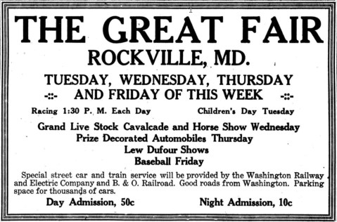 In 1846, James K. Polk was President of the United States, the U.S. flag had only 28 stars on it, and less than 1,500 people lived in Rockville. It also was the year that the Montgomery County Agricultural Society was organized, that began the tradition of the Montgomery County Fair in Rockville. A 12-member board of directors was chosen, headed by John P. C. Peter, President. The Montgomery County Fair opened two years later on the Pike in 1848, about where Richard Montgomery High School is today.
Discussions about farm improvements led to organized agricultural efforts. In 1846, Rockville farmers helped to establish the Montgomery County Agricultural Society. Two years later, Court House Square overflowed with displays of agricultural implements at the first county fair. The register of will opened his office for exhibits of household manufacturers. and the county clerk’s place teemed with fruits and vegetables. Women competed for cash prizes in the categories of homespun fabrics, fancy handwork, pickles, preserves, butter, cheese, and honey. Men exhibited livestock on the grounds of the Beall-Dawson House.
In a few years, the fair moved to Samuel T. Stonestreet’s woodlot adjacent to Saint Mary’s Church. The annual fair became a week-long gathering to showcase innovation, compete, and socialize. The property on the Rockville Pike was used until 1932, after which much of the land became Richard Montgomery High School.
From The Baltimore Sun Newspaper on September 20, 1848:
The Montgomery County Agricultural Fair held at Rockville, Maryland on Thursday and Friday last, the Journal of that place says, fully met the most sanguine expectation of its friends. The concourse of people was very large, and the stock, implements, and other articles exhibited, were the most perfect and beautiful. The Journal designs to publish the various reports of the committee—and the very able and interesting address of R. J. Bowie, Esq., and the other appropriate remarks submitted on the occasion, and says:
The exhibition was highly credible to the officers and members of the club, and to our country. We must reserve, for a more lengthy notice, the beautiful stock and implements of agriculture sent by gentlemen residing out of our county. We are gratified, indeed, that every thing went off gloriously, and the occasion will be long remembered by all who were present.

The Baltimore Sun, Sunday 31 August 1909
All the latest improved machinery in farm and garden implements were there, together with wagons, carriages, automobiles, trucks, and tractors. The display of cattle, sheep and hogs had long been one of the leading features at the Rockville Fair. Many fine herds of cattle, including Jerseys, Guernseys and other varieties were on exhibition. Two hundred of the finest horses in Montgomery County, along with many from the District of Columbia, nearby Virginia, and elsewhere were on exhibition. In this respect, the Rockville Fair was equal to that of any state.

Fair-goers in their finest stroll along the midway. Hats were a fashion requirement at the time, as were long flowing dresses and suits. Photo by Lewis Reed, ca. 1910
Many other attractions were provided, including the midway, merry-go-round, Ferris wheel, side shows, free exhibitions in front of the grandstand, horse racing, pony races, mule races, automobile contests, a parade of stock, horse show, dog show, poultry show, an automobile show, and clay pigeon shoots. The clay-pigeon shoot was one of the biggest events of its kind ever held in Maryland.

Ferris Wheel at the Rockville Fair. Photo by Lewis Reed, ca. 1910

Agricultural and various farm equipment exhibits. Photo by Lewis Reed, ca. 1910
The various departments were filled to overflowing with high-class exhibits. The main exhibition hall was devoted to farm products and garden products, household displays, flowers, fruits, etc. The household department had an endless array of preserves, jellies, canned fruits, bread, cakes, candles, pies, fancy articles, and works of art. Sanders & Stayman and E. F. Droop & Co. of Washington, had excellent displays of musical instruments in this hall. Examples of locally grown produce were abundant in the main hall. Peaches, apples, plums, damsons, cantaloupes and watermelons were piled up in tempting array. The poultry show was also a place of interest. Many fine chickens, turkeys, geese, ducks and pigeons were being shown.

Fair-goers meander through exhibits. Photo by Lewis Reed, ca. 1910

Can you hear me now? Photo by Lewis Reed, ca. 1910

Hundreds of cars parked in the fair parking lot. Photo by Lewis Reed, ca. 1910.
The Fair was always attended by large numbers of visitors from Frederick, Howard, and Carroll counties, the District of Columbia and Loudoun, Fairfax and Arlington counties, Virginia. Vehicles were assigned places all around the fairgrounds, and the park was completely surrounded. What is fascinating to me is, with all of these early cars painted in black, how on earth would you find your car?

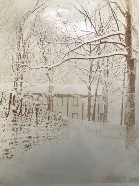
Montgomery County Fairgrounds in the snow. Photo by Lewis Reed, ca. 1910
Montgomery County Fairgrounds Chicken House. Photo by Lewis Reed, ca. 1910

Sign on the left side of the building reads, “The Beautiful Caverns of Luray Souvenirs”. Photo by Lewis Reed, ca. 1910
Aftermath of War
During the war the fencing, outbuildings, stables, etc. were very badly used by both the Union and Confederate soldiers, necessitating considerable expenditure to restore the grounds to their ante bellum appearance. The Montgomery County Agricultural Society estimated a cost of nearly $8,300 to rebuild fences, lay out a new race track, repair fields, and reverse four years of use by the troops. Improvements were made comprising within about 16 acres a one-third of a mile long track, separate stables for 50 horses, a two-story frame building for the exhibition of field, garden and orchard products, household industries, and cattle and stock pens.
Bicycle Races
Bicycle races became very popular throughout the country and were an event at the Fairgrounds as early as 1915. The race track was a half-mile dirt racing oval with wide, sweeping curves and a grandstand for spectators, and was easily adapted for bicycles, harness racing, and the sport of car racing.

This circa 1915 photo of an early bicycle race at the Rockville Fairgrounds gives a sense of just how popular the sport was at the time. Photo by Lewis Reed
Harness Races

Rockville drew huge crowds for harness races. Photo by Lewis Reed, circa 1910

Harness race at the Rockville Fair, circa 1910. All those throngs of people had plenty to see. Photo by Lewis Reed

Harness racers rounding the bend on the racetrack, Rockville Fairground circa 1910. Photo by Lewis Reed

Bend on the harness racetrack, Rockville Fairground circa 1910. Photo by Lewis Reed

Race horse and two-wheeled sulkies (for trotting races) at the Rockville Fairground stables. Photo by Lewis Reed ca. 1910
Automobile Races
August 25, 1923 was the first year that the Rockville Fair continued through a Saturday. The extra day was added as an experiment, the management believing that by substituting new features, the additional day could be made a success. Automobile races, the first ever held at Rockville, were the day’s principal attraction and they attracted a huge crowd. The photos below taken by Lewis Reed reveal what auto racing looked like in the days before helmets, seat belts, air bags, and traction control.

Rockville drew huge crowds for auto races. Rockville Fair, August 25, 1923. Photo by Lewis Reed

Dusty Action – 1923 photo of the exciting auto races at Rockville Fair. Five racers are just coming around the bend on this dirt track with their tires spinning up dust in their wake. Photo by Lewis Reed

Race car drivers deep in dust round a turn at the Rockville Fair auto races. Print made from a Lewis Reed glass negative.

High-powered race cars rounding a wide, sweeping curve at the Rockville Fair auto races, August 25, 1923. Print made from a Lewis Reed glass negative

Two-man race car. Some early race cars included both a driver and a ‘riding mechanic’. One of the key jobs of the second man in a race car was to look backward and alert the driver to what was going on behind him. Photo by Lewis Reed
Early race car drivers were required to have a riding mechanic, otherwise it was voluntary. Riding mechanics, who in addition to being lookouts, kept an eye on tire wear and would even hop out of the car and run back through the infield to get fuel.

More dirt track action. Skinny tires make for slippery turns. Photo by Lewis Reed
Rockville Garage Displaying New Model Cars at Rockville Fair Grounds, 1918
The Fair also gave automobile dealers the opportunity to display their new models. Below is new car show time as fair-goers get their first glimpse at the latest models that Rockville Garage had to offer.

Anybody for a demonstration drive? Identified by the triangle logo on the grill and the number of passengers seated in it, the car appears to be a 1918 Hudson Super Six Seven Passenger Touring. Photo by Lewis Reed

Hudson Super Six, Oldsmobile, and Dodge Brothers Motor Cars on display. Lewis Reed in drivers seat.

Rockville Garage displaying their new models at the Rockville Fair Grounds. Photo by Lewis Reed

At Your Service Rockville Garage. Lewis Reed on the left
Fair Now History
From The Daily Mail (Hagerstown, Maryland) 23 Aug 1933:
The historic Rockville Fairgrounds, scene of many harness race programs, will be sold at a sheriff’s sale Friday afternoon at Rockville. The property consists of 26 acres, a dwelling and numerous stables, exhibition buildings and other structures. The sale is being made to satisfy a claim of a bank. It is rumored that the Montgomery County Board of Education will try to buy the grounds as a site for an elementary school and a future location for the entire Rockville educational plant.
Fair Ground Auctioned
From The Evening Sun (Baltimore, Maryland) 26 Aug 1933:
The Montgomery County National Bank submitted the only bid for the historic Rockville Fair Grounds at a public auction on August 25, 1933 to satisfy a bank’s claim. Its bid was $19,500.00 subject to a mortgage held by the Sandy Spring Savings Institution, and unpaid interest and taxes.
The Montgomery County Fair was reborn in 1949 and again started holding its annual Fair in Gaithersburg. On June 4th, 1949, hundreds of volunteers participated in an old-fashioned barn raising and 12 outbuildings were constructed in one day. The site of the new Montgomery County Agricultural Center was created.

June 4, 1949 – Construction of the cattle barns along the railroad tracks. Photo courtesy of Montgomery County Fair photo archives
Sitting on 62 acres, the Fair has more than 50 buildings that are filled with more than 5,000 animals every year. The Fair has animals, entertainment, food, commercial, home arts, arts and crafts exhibits, and many others for the whole family to enjoy.
The Montgomery County Fair is now today, one of the largest county Fairs in the State of Maryland.
References:
Chronicling America: Historic American Newspapers. Library of Congress
Newspapers.com: the largest online newspaper archive
Rockville, Portrait Of A City, Eileen S. McGuckian
Ag Center History
Lewis Reed Captures the Thrill of Motorcycle Racing in 1915

A motorcycle racer rips down an unknown racetrack kicking up dust in his wake. Photo by Lewis Reed, ca. 1915
In the first years of the twentieth century, companies like Harley-Davidson and Indian began producing motorcycles for the general public. Although there is not an exact date of the first motorcycle race, you can be sure that as soon as there were two motorcycles on the road, there was racing. As more and more motorcycle manufactures started popping up across the U.S., motorcycle racing started making it’s way to more official venues. The earliest races were held on fairground dirt tracks used for horse racing.
This photograph taken by Lewis Reed shows an unknown racer at a fairground raceway in the early 1900s. In the teens, motorcycle racing on dirt tracks throughout the country, was one of the most popular spectator sports. Despite the danger to both racers and spectators, the motorcycle races became very popular and drew large crowds of spectators. Motorcycle racing continued until just after World War 1, when the focus shifted to automobile racing.
Featured Photo: Popes Creek Post Office, 1910

Popes Creek Post Office on the Potomac River. Photo by Lewis Reed, ca. 1910
It’s hard to imagine a world without cars, buses, and trucks. But put yourself back in the early 20th century. Before the invention of trains and automobiles, animal power was the main form of travel. Horses, donkeys, and oxen pulled wagons, coaches, and buggies. Early settlers often used oxen to pull their big wagons. Oxen were slower than horses, but they could pull four times as much weight.
In this circa 1910 photograph taken by Lewis Reed, two men pose with an ox-drawn wagon in front of the little Popes Creek Post Office on the Potomac River. Two elegantly dressed women with hats stand outside on the porch. Note the two-person horse buggy on the right. The Potomac River is visible in the background. The Popes Creek Post Office probably served as a social gathering place for the community.
A bit of history: Popes Creek is an unincorporated community in Charles County, Maryland. It is located on the shore of a north-south section of the Potomac River north of and in sight of the Harry Nice Memorial Bridge. To the north is Port Tobacco Village, Maryland, and to the southeast the Cobb Island peninsula. Pope’s Creek has a long and varied history. Near here, John Wilkes Booth was rowed across the river, a week after he assassinated President Abraham Lincoln. The creek itself was named for Nathaniel Pope, an early landowner in the area.
Reference: Wikipedia
Then & Now: Clopper Grist Mill
This post is a continuation of a series of “Then & Now” images that will show photographs of buildings, street scenes, and other historical locales from Lewis Reed’s Photo Collection alongside photographs of how they appear today. Taken approximately 109 years apart, these photos show the Clopper Grist Mill then and now.
Clopper Mill (THEN): Francis Cassatt Clopper bought this mill and 541 acres in 1810, but the earliest mention of a mill on this site dates back to 1777. Clopper’s mill was a square, three-story grist mill, with basement and first floor levels made of local field stone and a third story of brick. The mill was destroyed by a fire in 1947.
On April 15, 1865 Clopper Mill became part of national history when would-be assassin of the Vice President of the United States, George Atzerodt, spent the night there while fleeing from Washington D.C. after the assassination of President Lincoln. George was part of the gang assembled by John Wilkes Booth to eliminate the heads of the U.S. government. He was supposed to kill Vice President Johnson at the Willard Hotel at the same time as Booth assassinated the President. But Atzerodt ran out of courage and instead made his way to Germantown.

Clopper Grist Mill. Photo by Lewis Reed, ca. 1910
Clopper Mill (NOW): The ruins of this large brick and stone mill stand on the west bank of Great Seneca Creek, just south of Clopper Road near the intersection of Warring Station Road. The property was acquired by the State in 1955 as part of Seneca Creek State Park.

Clopper’s Mill Ruins today.
Books
![]()
Related Resources


Copyright Notice

Reed Brothers Dodge History (1915-2012) by Jeanne Gartner is licensed under a Creative Commons Attribution-NonCommercial 3.0 Unported License.

Recent Comments