
Then & Now: Clopper Grist Mill
This post is a continuation of a series of “Then & Now” images that will show photographs of buildings, street scenes, and other historical locales from Lewis Reed’s Photo Collection alongside photographs of how they appear today. Taken approximately 109 years apart, these photos show the Clopper Grist Mill then and now.
Clopper Mill (THEN): Francis Cassatt Clopper bought this mill and 541 acres in 1810, but the earliest mention of a mill on this site dates back to 1777. Clopper’s mill was a square, three-story grist mill, with basement and first floor levels made of local field stone and a third story of brick. The mill was destroyed by a fire in 1947.
On April 15, 1865 Clopper Mill became part of national history when would-be assassin of the Vice President of the United States, George Atzerodt, spent the night there while fleeing from Washington D.C. after the assassination of President Lincoln. George was part of the gang assembled by John Wilkes Booth to eliminate the heads of the U.S. government. He was supposed to kill Vice President Johnson at the Willard Hotel at the same time as Booth assassinated the President. But Atzerodt ran out of courage and instead made his way to Germantown.

Clopper Grist Mill. Photo by Lewis Reed, ca. 1910
Clopper Mill (NOW): The ruins of this large brick and stone mill stand on the west bank of Great Seneca Creek, just south of Clopper Road near the intersection of Warring Station Road. The property was acquired by the State in 1955 as part of Seneca Creek State Park.

Clopper’s Mill Ruins today.
Montgomery County Police Department Celebrates 97th Anniversary (1922-2019)

This is the first known photograph of the entire MCPD. Pictured left to right: Earl Burdine, Lawrence Clagett, Guy Jones, Chief Charles Cooley, Leroy Rodgers, and Oscar Gaither. Photo taken by Lewis Reed on July 4, 1922.
Today marks the 243rd anniversary of the birth of our nation and the 97th anniversary of the beginning of the Montgomery County Police Department. Cattle rustling, bootlegging and stealing poultry were among the most common crimes when Montgomery County hired its first police chief and five officers in July 1922. So widespread was the theft of chickens and turkeys that some residents employed a homespun form of crime prevention by cutting off a specific claw on their birds to identify them. “Officers knew who all the chicken thieves were,” said one historical account of the era put together by the police department, “and upon getting a report of missing Rhode Island Reds, or some other breed, would head straight for the thieves’ hideaway to try to catch them ‘red handed’ before the birds got to the frying pan.”
Posing in front of Reed Brothers Dodge on July 4, 1922 Chief Charles Cooley, center, and his men of the first mounted unit of the Montgomery County Police Force, were on their first day of duty. For several years, since there was no police station, the officers would meet for “roll call” on the steps of the Red Brick Courthouse in Rockville at 2:00 p.m. every day to let each other know they were alive and well. Chief Cooley was given the privilege of a Model T Ford. The chief was paid $1,800 a year (the chief now gets $112,564) while the officers got $1,500. Each of the officers was issued a Harley-Davidson motorcycle, a .38 Smith & Wesson handgun, a black jack, law book and was allotted $300.00 a year for the upkeep of their motorcycle. Jones patrolled Silver Spring, Rodgers the Bethesda-Chevy Chase area and Burdine, Clagett and Gaither the Upper County areas.
The county’s population in the early 1920s was just 35,000 (it’s now more than 800,000). Much of the county was farmland, which accounted for the thefts of livestock. It also was the Prohibition era, when bootlegging and moonshine still factored routinely on an officer’s shift.
The officers worked 14 hours at night, 10 hours in the day, with two days off every two weeks. But they were on call at all times. Since there was no mobile radio contact (the first one-way radio system was installed in cars in the early 1930s), the officers tended to hang around the courthouse or a local firehouse that had a phone.
One of the officers came up with the idea of placing a flashing red beacon light on a pole atop the Rockville courthouse. When flashing, it would alert police that they had a call or were wanted at the office. In 1927, similar lights were used at district stations in Silver Spring and Bethesda.
Congratulations MCPD and thank you for your many years of service!
Montgomery County High School 100 Years Ago
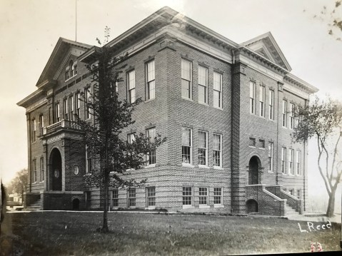
Originally known as Montgomery County High School, later as Rockville High School and Richard Montgomery High School. Located at the corner of Monroe Street and East Montgomery Avenue. Photo by Lewis Reed, circa 1906.
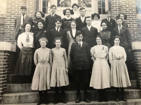
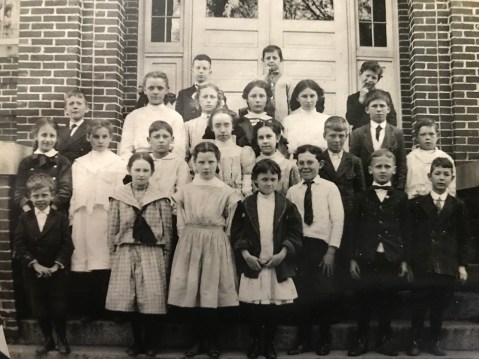
High school picture day is a tradition that dates back to the beginning of the 20th century. In honor of this year’s commencement, here is a look back at a collection of group photos of school children from Montgomery County High School that were taken by Lewis Reed in 1910. Most of the photos are labeled with only the year, so if you have corrections to the names or can identify other individuals, please contact me or leave a comment below. Several students have been identified by the Montgomery County Historical Society, which I have included.
A bit of history: Located in the City of Rockville, Richard Montgomery High School is the oldest public high school in Montgomery County. An allocation in 1892 by the then Board of School Commissioners of a $300 addition to the existing elementary school in Rockville brought to fruition the then named “Rockville High School” that served students from grades one to eleven. The first class of twelve seniors graduated in 1897. In 1904, the Board of Education purchased land at the corner of Montgomery Avenue and Monroe Street for the construction of a new school building, to be renamed “Montgomery County High School” at Rockville. Students came to the school by train, trolley, and later by school bus from all corners of the county. In 1935, when the new “Rockville Colored High School” building opened in Lincoln Park, the Board of Education officially renamed the old Rockville High School, “Richard Montgomery High School.”
Step back in time into a much simpler past and get a look at class photos of Montgomery County High School students from over a century ago. As always, click the photos to get a better look. Some of the expressions on these students faces are priceless!
Montgomery County High School class ca. 1910. Photo by Lewis Reed
Back row: Edward Story, Lena Ricketts, Tom Young, Louise Larcombe, Miss Ford, Fred Hays, Lucius Lamar, name unknown, name unknown.
Middle Row: name unknown, name unknown, Jesse Wathen, Jesse Higgins, name unknown, name unknown, Mary Hyatt, name unknown, name unknown.
Front Row: Maude England, Rebecca Lamar, (first name unknown) Garrett, Helen Pumphrey, (first name unknown) Lehman.

Montgomery County High School class, ca. 1910. Photo by Lewis Reed
Back: Harry Beall, Katherine Hughes.
Middle: names unknown
Front: Edith Prettyman, (first name unknown) Darby
Rockville High School’s First Baseball Team
Interschool athletics in Montgomery County began with a meeting, duly noted in the Sentinel of February 18, 1910, of the principals of the high schools at Rockville, Gaithersburg, Kensington, and Sandy Spring to formulate plans for a baseball league. Within a month, the athletic association of Rockville High School was formed with Roger J. Whiteford, principal, as manager of the baseball team, Edward Story, teacher, as assistant manager, and Jesse Higgins student, as captain.

Rockville High School First Baseball Team, 1910. Photo by Lewis Reed
Front: Billy Beck, Tom Young, Edward Storey, Harry Beall, Roy Warfield.
Back: (first name unknown) Hicks, Lucius Lamar, name unknown, name unknown, Jesse Higgins, name unknown, name unknown, Fred Hays, Roger Whiteford
Holding pennant: Griffith Warfield

Montgomery County High School 1910. Photo by Lewis Reed

Montgomery County High School 1910. Photo by Lewis Reed

Montgomery County High School 1910. Photo by Lewis Reed
Montgomery County High School 1910. Photo by Lewis Reed
Times have changed dramatically since Montgomery County High School first opened its doors in 1892. One has only to think of the difference between chalk and slate and the new Promethean ActivBoards to begin to understand the new world in which we live.
Credit to: E. Guy Jewell, “Richard Montgomery High School.” The Montgomery County Story Vol. 24 (1981)
Then & Now: State of Pennsylvania Monument (Gettysburg)
In this “Then & Now” feature, I have combined one of Lewis Reed’s original photograph’s for “then” and matched it with a corresponding contemporary shot for “now”. The Pennsylvania State Memorial is a monument in Gettysburg National Military Park that commemorates the 34,530 Pennsylvania soldiers who fought in the July 1 to 3, 1863 Battle of Gettysburg during the American Civil War. These photos show the same view taken about 109 years apart.
State of Pennsylvania Monument (THEN): This rare photograph was taken by Lewis Reed of the State of Pennsylvania Monument while under construction. Completed in 1914, it is the largest of the state monuments on the Gettysburg Battlefield. Taken approximately 109 years apart, these photos show the State of Pennsylvania Monument then and now.

State of Pennsylvania Monument Under Construction, ca. 1910. Photo by Lewis Reed
State of Pennsylvania Monument (NOW): The State of Pennsylvania Monument (at 110 feet tall) incorporates individual sculptures commemorating the six Keystone State generals who fought at Gettysburg — plus President Abraham Lincoln and Governor Andrew Curtain — and 90 bronze plaques emblazoned with the names of each of the 34,530 Pennsylvanians who fought in the battle. It cost $240,000 to build in the early 1900s, or almost $6 million in 2018.

State of Pennsylvania Monument as it is today.
Source: Wikipedia
Site History Shown With Sanborn Maps
For over a half-century at the triangle, Reed Brothers Dodge became a community icon and a local landmark for motorists traveling to and through Rockville. Recently, I have been interested in discovering more about the early history of the Rockville Garage, which was originally located in the triangle at the intersection of Veirs Mill Road and Rockville Pike. I wanted to know “what was there before” and “how and when it got there”. Sometimes it can be hard to imagine just what a building, street, or neighborhood looked like a century ago. A little bit of creative research can uncover a wealth of information in records that were intended to serve a different purpose, and valuable information can be found from unexpected sources like the Sanborn maps. This post features a series of historical Sanborn Fire Insurance Maps of Rockville to illustrate how Rockville Garage/Reed Brothers Dodge evolved in the city’s built environment from 1915 to 1960. Originally in color, the digital editions are line drawings only, but provide a great amount of historical data.
From the late-1800’s to the mid-1960’s, the Sanborn Map Publishing Company of New York City created complex footprint maps of approximately 13,000 American cities. Fires were an all-too-common danger, sometimes wiping out major portions of a block. Insurance companies went to great lengths to know what they were insuring. They periodically sent out map-making teams to gather information about the buildings in cities they served. Rockville was one of those cities. The Sanborn Fire Insurance Company produced maps of Rockville in 1892, 1897, 1903, 1908, 1915, 1924, 1949, and 1960.
In this post, I have included a zoomed-in map to show detail. Below the map is a photograph that provides a visual of how Reed Brothers Dodge grew over the years. (click images to enlarge)
Aug 1908 Rockville Sanborn Map

Aug 1908 Rockville Sanborn Map (zoomed in)
Throughout the late 19th and early 20th centuries, Sanborn maps were regularly updated as cities and towns grew and changed. Specific changes in an individual site such as when a building was built, expanded, or torn down, can often be dated within a reasonably accurate time frame, depending on how many different map editions for that city are available. These maps provide a very detailed picture of Reed Brothers Dodge at different stages in its history.
The Aug 1908 Sanborn map shows the junction of Rockville & Georgetown Turnpike and Washington Road before the Rockville Garage existed. The map reveals three, two-story dwellings. Letters A, B, and C in front of the dwellings are arbitrary identifications supplied by the Sanborn Map Company. These identifications were necessary in the absence of official numbers actually posted on the buildings.
The Montgomery County Agricultural Society fairgrounds (aka Rockville Fair) was located directly across the Rockville & Georgetown Turnpike. Compared to the Rockville of today, the sparseness of structures in this 1908 map really stands out.
Nov 1915 Rockville Maryland Sanborn Map

Nov 1915 Rockville Maryland Sanborn Map, Sheet 5 (zoomed in)
The zoomed-in image of the Nov 1915 map shows the one-story Rockville Garage at the junction of Rockville & Georgetown Turnpike and Washington Road. Lewis Reed and brothers Robert and Griffith Warfield established the Rockville Garage in this location after acquiring the building from Lee Ricketts and Sons in July 1915. These maps are quite specific, not only in representing graphically the dimensions of buildings and spaces around them, but also in the details of the construction materials and activities that took place there. Notes on this map indicate that the garage had a 15-car capacity as well as a single gasoline pump. You can also see notes written in regarding building features such as “Heat: Stove In Office”— “Lights: Electric”— “Earth Flr”. They also noted the buried gas tank and where it was located with a small circle. The number “28” represents the official designation for the block provided by the city or arbitrarily by the Sanborn Map Company. The triangle is currently occupied by Rockville Garage, five two-story dwellings, and one vacant lot. In 1916, Lewis Reed purchased 6 lots in Rockville (Land Record, 294/375) and began his expansion in 1917 with a two-story addition behind the original garage.
Note: “CADIZ ALLEY” is an arbitrary designation supplied by the Sanborn Map Company in the absence of a suitable official name. “Cadiz Alley” would later become “Dodge Street”.

Original 1915 Rockville Garage located at the intersection of Veirs Mill Rd and Rockville Pike. The single gas pump can be seen in front. The roofs of three two-story dwellings are visible behind the garage.
Nov 1924 Rockville Maryland Sanborn Map

Nov 1924 Rockville Maryland Sanborn Map, Sheet 7 (zoomed in)
This enlarged view from the 1924 map shows the garage capacity increased to 30 cars. If you look closely, you can see the annotations “G.T.” by four open circles—these indicate the gasoline supply is stored in tanks buried just in front of the building. Solid black circles mark the location of fire hydrants. The dealership’s Office is identified by “OFF”. Saint Mary’s Church and Cemetery is also visible where it still stands today. Other notes written in regarding building features include “Heat: Steam”— “Lights: Electric”. The small circles in the corners of the main building indicated it had a slate or tin roof. The numbers immediately in front of the buildings facing the streets are the official address numbers.

Reed Brothers Dodge got a new remodel in 1921. The original part of the garage was converted into a new car showroom and the service operation was moved out into the rear portion of the building. The Rockville Fairgrounds are beyond the boarded fence. Photo by Lewis Reed
By tracking Reed Brothers Dodge on successive Sanborn maps—1915, 1924, 1949 and 1960—I have confirmed a couple of things. First, Lewis Reed purchased a total of 6 residential lots in the triangle to expand his business. The expansions took place over the course of about 50 years—from 1917 to about 1953. Second, and more curiously, sometime between 1924 and 1949, Cadiz Alley became “Dodge Street”. The street was named “Dodge Street” by the State of Maryland sometime following the dealership’s 1941 expansion. The number “28” marks the spot where Reed Brothers constructed completely new buildings for the Parts and Service Departments.
June 1949 Rockville Maryland Sanborn Map, Sheet 10

June 1949 Rockville Maryland Sanborn Map, Sheet 10 (zoomed in)
After 1924, there is a large gap in the sequence of Sanborn maps, and the next survey was published in 1949. This map shows the expansion of the showroom and Gulf Gas Station that took place during the mid-1930s. At about the same time as the gas station was remodeled, Lewis Reed split up the Sales and Parts and Service operations by constructing a complete new building; it was located at the intersection of at Montgomery Avenue and Dodge Street. In this image of the June 1949 map, you can see notes written within the “Auto Repair” building regarding construction materials such as “Cinder Block”—“Steel Trusses”— “Pilasted Walls”—”Conc. Fls”. This map reveals that Reed Brothers has implemented automatic sprinklers throughout Auto Sales & Service as indicated by the symbol “AS” within a circle. The solid black circle with “D.H.” at the top of the map identifies a Double Hydrant. New buildings for Auto Sales & Service and Auto Repair have replaced dwellings A, B, and C. One remaining two-story dwelling stands near the back of the dealership, in front of the new Parts and Service building. Block number (28) has been changed to “97”.

Mid-1930s aerial view of Reed Brothers at the intersection of Veirs Mill Road and Rockville Pike. A two-story house stands behind the dealership. Photo taken by Lewis Reed from a Goodyear Blimp that came to the dealership in the late 1930s to promote tires.
June 1949 Rockville Sanborn Map, Sheet 10, Revised Jan 1960

June 1949 Rockville Sanborn Map, Sheet 10, Revised Jan 1960 (zoomed in)
This final map is a new report that was updated in Jan 1960. Due to changes in the highway in 1953, Reed Brothers began an extensive remodeling and rebuilding program. The program consisted of a sizable addition to the service shop which enlarged the showroom area and housed the Parts Department. Two-thirds of the original location at the junction of Montgomery Avenue and Veirs Mill Road was razed and a modern Gulf Service Station was erected. The zoomed-in map reveals the new Gulf “ice box” design filling station in front. The last two-story house was demolished and replaced with a parking lot and used car lot, which now completes the triangle.

1960s aerial view showing the used car lot where previously stood a two-story house. Photo by Lewis Reed
Today, Sanborn maps are rarely used by insurance companies, having been supplanted by new technologies. However, these maps remain a vital source of historical information. The Sanborn Fire Insurance Company’s maps are a great way to get a visual sense of the development and changes that took place in the city over time. Today, they can be invaluable for uncovering a business’s long-lost historical details.
Notes: All map screenshots in this post are courtesy of the Library of Congress digital collection of Sanborn maps.
The original Sanborn maps were printed in color, so some details from the original historical maps do not show.
Books
![]()
Related Resources


Copyright Notice

Reed Brothers Dodge History (1915-2012) by Jeanne Gartner is licensed under a Creative Commons Attribution-NonCommercial 3.0 Unported License.

Recent Comments