
Then & Now: Clinton Zion AME Church, Rockville
In 1867, several of Rockville’s African American families left Jerusalem Methodist Episcopal Church to start the African Methodist Episcopal (A.M.E.) Zion Church under the leadership of Reverend Charles Pipkins. In 1890, Pipkins and his congregation cut timbers and erected. a frame church on Middle Lane. Taken approximately 100 years apart, these photos show the Clinton Zion A.M.E. Church then and now.
Clinton Zion A.M.E. Church (THEN): In 1904, the congregation moved to the brick church seen in this black & white photograph located on North Washington Street and today’s Beall Avenue. The church was named Clinton A.M.E. Zion in honor of Reverend George Wylie Clinton (1859-1921), a prominent member and editor of the church’s periodical, Star of Zion.

Zion A.M.E. Church, Rockville, Maryland. Photo by Lewis Reed, ca. 1912.
Clinton Zion A.M.E. Church (NOW): The congregation sold the brick church in 1955 to make way for a shopping center, dedicating their present church on Elizabeth Avenue in Lincoln Park in the fall of 1956. The growth of Clinton was the impetus for the most recent expansion effort. Construction of the new sanctuary began in 1989 and the newly renovated edifice was dedicated on Sunday, May 13, 1990.
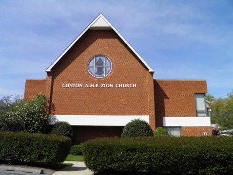
Zion A.M.E. Church, Rockville, Maryland. 2012
Source: Clinton AME Zion Church
Then & Now: Hagerstown Public Square
This post is a continuation of a series of “Then & Now” images that will show photographs of buildings, street scenes, and other historical locales from Lewis Reed’s Photo Collection alongside photographs of how they appear today.
Hagerstown Public Square (THEN): Hagerstown Public Square looking north on Potomac Street, circa 1913. D. Ramacciotti’s fruit and candy store dominated the left side of the square. Trolleys roll down the middle of the street and a piano store is on the right. Winding the giant clock in the background (still there today) was done by a line from the tower attached to a horse on the ground that pulled the clock’s weights up through the tower.

Hagerstown Public Square, 1913. Photo by Lewis Reed
Hagerstown Public Square (NOW): Traffic heads south on Potomac Street on the square in downtown Hagerstown 105 years later.

Hagerstown’s Public Square, looking north on Potomac Street, as it is today.
Then & Now: Quebec Bridge (8th Wonder of the World)
The Quebec Bridge (Pont de Québec in French) has been an icon of Canada for more than a century. But did you know that the Quebec Bridge collapsed twice (1907 & 1916) before it was completed, making it the world’s worst bridge construction disaster. Taken approximately 90 years apart, these photos show the Quebec Bridge (8th Wonder of the World) then and now.
Quebec Bridge (THEN): Hailed at the time as the 8th wonder of the world, the Quebec Bridge was the first bridge over the St. Lawrence River in Montreal. Accommodating three highway lanes, one rail line and a pedestrian walkway, it represented a colossal challenge to construct at the time. First conceived in 1887, the bridge collapsed failed twice, at the cost of 88 lives, and took over 30 years to complete. A riveted steel truss structure, the Quebec Bridge is the longest cantilever bridge span in the world. The Quebec Bridge was declared a historic monument in 1987 by the Canadian and American Society of Civil Engineers, and on January 24, 1996, the bridge was declared a National Historic Site of Canada.

Quebec Bridge (8th Wonder of the World). Photo by Lewis Reed, ca. 1930
Quebec Bridge (NOW): The same view almost 90 years later. The bridge remains in use to this day, carrying both road and rail traffic. rails in the middle and roadways on both sides.

Night view of the Quebec Bridge, today. Photo credit: Martin St-Amant – Wikipedia
Source: Wikipedia
Then & Now: Rockville Fair Dirt Track Oval
The black and white photograph of the Rockville Fair auto races below was taken by Lewis Reed in 1923. The photograph was from the first incarnation of the Fair, held by the Montgomery County Agricultural Society (1846-1932) in Rockville and often known simply as the “Rockville Fair.” For this “Then & Now” feature, I have combined Lewis Reed’s original photograph for “then” and matched it with a corresponding contemporary shot for “now” to see how the location has changed throughout almost 95 years.
Rockville Fair Dirt Track Oval (THEN): Like many fairgrounds, the Rockville Fairgrounds included an oval track. Fairground race tracks, typically one-mile or half-mile dirt racing ovals with wide, sweeping curves and grandstands for spectators, were easily adapted for bicycles, harness racing, and the sport of car racing. Harness racing was one of the main attractions, but after the introduction of the automobile in the early 20th century, car races took over. The fairgrounds were just outside Rockville, where Richard Montgomery High School is today.

Crowds at the auto racetrack, Rockville Fair, August 1923. Photo by Lewis Reed
Rockville Fair Dirt Track Oval (NOW): In 1946, after the construction of Richard Montgomery High School, the old oval race track became a football field and stadium.
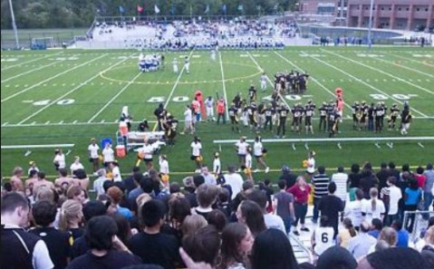
Richard Montgomery High School football field and stadium today
Then & Now: New Occidental Hotel Washington, DC
In this “Then & Now” feature, I have combined one of Lewis Reed’s original photograph’s for “then” and matched it with a corresponding contemporary shot for “now” to see how the location has changed or remained nearly the same through the years. I started doing this as a research tool, now I mostly do it because of my passion for history and fascination with the subject. In the following photographs, you can see the difference 100 years can make.
New Occidental Hotel (THEN): The New Occidental Hotel was built by Henry Willard (of Willard Hotel fame) in 1906. If any of 2,500 celebrities — including four presidents — forgot who they were, they could stop by the Occidental Restaurant on Pennsylvania Avenue and check their picture on the wall. Within a few years the Occidental became known as the place “Where Statesmen Dine”.
After the restaurant closed in 1971, the wall-to-wall collection of paintings and photographs of the famous was auctioned off. The new Occidental Restaurant re-opened at 1475 Pennsylvania Ave. NW, almost on the old site, as part of the Willard Collection of buildings.
Looking from the Treasury Building directly at the United States Capitol, this 1912 photograph taken by Lewis Reed shows the first floor retail shops and the Occidental Hotel, which has an Electric Grill Room, on the left. On the right are office buildings and the Old Post Office. The magnificent Raleigh Hotel held a commanding position on Pennsylvania Avenue across from the Old Post Office Building. The Occidental Hotel was located at 1411 Pennsylvania Avenue NW.

Historic street view of Pennsylvania Avenue. Photo by Lewis Reed, 1912
New Occidental Hotel (NOW): Google Street View from approximately the same perspective in 2018.

Screenshot of Google Street View 2018
Books
![]()
Related Resources


Copyright Notice

Reed Brothers Dodge History (1915-2012) by Jeanne Gartner is licensed under a Creative Commons Attribution-NonCommercial 3.0 Unported License.

Recent Comments