
Then & Now: Tenallytown & Rockville Pike Trolley Line
The latest installment in my Then & Now series takes us to south of Montrose Road where the Tenallytown and Rockville Pike trolley line intersects with Rockville Pike. The black & white photo was taken by Lewis Reed in 1910. The corresponding color photo is a Google Maps image, more than 100 years later. Matching the photos was a bit difficult as the location has changed so much, but you get the idea.
The Tennallytown and Rockville Railroad, which opened in 1890, was an extension of the Georgetown & Tenallytown Railway. The street car line was extended to Rockville in 1900 terminating at the fairgrounds. During the fair each fall, traffic was so heavy that two-car trains were run to accommodate the crowds. Later a further extension was made through Rockville on Montgomery Avenue to the Chestnut Lodge Sanitarium on the far side of town. In 1935, the Rockville trolley line ceased operation, leaving gasoline-powered buses as the only mode of public transportation serving this corridor until the Metrorail Red Line opened in 1984.
THEN: Tenallytown and Rockville Pike Trolley Line, 1910
In this photograph dated 1910, a trolley heads south from Rockville toward Tenallytown through open farmland. The view appears to be looking north and shows the area south of where Montrose Road intersects with Rockville Pike. The Pike is the white strip running diagonally behind the trolley car. The elevated vantage point, possibly from an adjacent rooftop or the roof of a barn, affords an excellent view of the rural countryside.

A trolley heads south from Rockville toward Tenallytown through open farmland. This view appears to be looking north and shows the area south of where Montrose Road intersects with Rockville Pike. The Pike is the white strip running diagonally behind the trolley car. Photo by Lewis Reed, 1910
NOW: The Bethesda Trolley Trail
Today, the six-mile Bethesda Trolley Trail connects Bethesda and Rockville for bicyclists, runners and pedestrians, following the route of the Tenallytown and Rockville Railroad, the former trolley line.

Woodglen Drive follows the old Bethesda Trolley Trail route today. The junction now is far from the tranquil road it once was. Google Maps image.
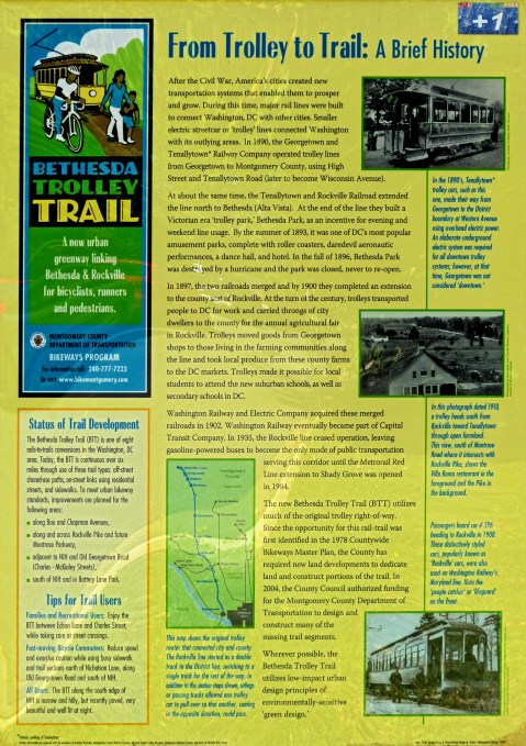
If there’s an historic wayside marker on the side of the road in Montgomery County, chances are, one of Lewis Reed’s images is on it. From Trolley to Trail Marker in Bethesda is one of many markers in Montgomery County that feature images from Lewis Reed’s collection of photographs.
From Trolley to Trail Marker in Bethesda
Location: Marker is in Bethesda, Maryland and can be reached from Norfolk Avenue near Rugby Avenue.
Duplicate: Another nearly identical marker is located at the exit ramp from westbound Montrose Parkway to northbound Rockville Pike (MD 355).
From Trolley to Trail Marker in Bethesda

From Trolley to Trail Wayside Marker in Bethesda. Close up of photos on marker taken by Lewis Reed.
Books
![]()
Related Resources


Copyright Notice

Reed Brothers Dodge History (1915-2012) by Jeanne Gartner is licensed under a Creative Commons Attribution-NonCommercial 3.0 Unported License.

Recent Comments