
Demolition of Original Rockville Garage Buildings (1971)
When the state widened the roads in 1970, Reed Brothers Dodge relocated its business to a brand new service complex at 15955 Rockville Pike, several miles north of its old location across from King Farm. The buildings on the Dodge Street site were all demolished to allow for re-routing of the Veirs Mill Road and Rockville Pike intersection.
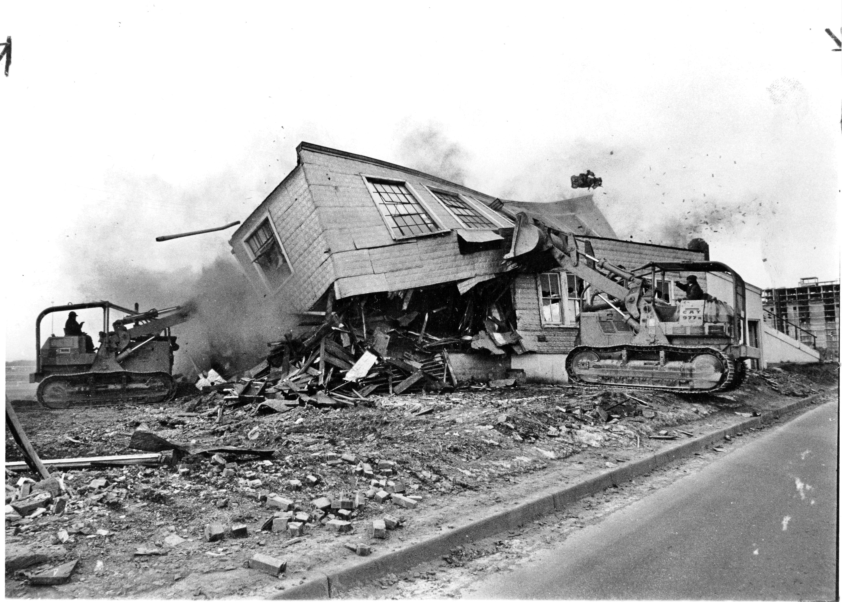
February, 1971: demolition of the original Rockville Garage buildings, which had stood on the Veirs Mill/Rockville Pike location for more than fifty years. (Montgomery History, Sentinel Photo Morgue)
Top photo from Montgomery History’s Sentinel Photo Morgue: Taken from Veirs Mill Road, the photo shows demolition of the original Rockville Garage buildings, which stood at the triangle site for more than 50 years.
Note: I think the picture captured the moment the bulldozer pushed the second story of the flat-roofed Body Shop OFF of the first, hence all the dust and debris flying in the air! Zoomed in, you can just see the edge of the old concrete ramp on the right side which led up to the Body Shop, as well as a partially completed building in the background, which I believe is the Americana Centre that opened in 1972.
Bottom photo: aerial view of the empty lot taken in 1971 after the business had been relocated and the buildings had been razed.
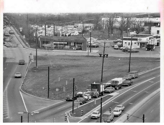
This photo of the Reed Brothers Dodge site was taken later in 1971, after the business had been relocated to 15955 Frederick Road and the buildings had been razed. (Montgomery History, photo by Bob Pusey)
Then & Now: Veirs Mill Road, 1911
Do you recognize the road pictured below? Few modern residents of Montgomery County would guess, but it is a shot of Veirs Mill Road before it was paved.
Veirs Mill Road (THEN): In the early 19th century, rural roads were often little more than muddy trails. The popularity of the car coincided with the improvement of public roads around Rockville. By 1929, when Montgomery County residents owned 13,000 cars, Rockville Pike and Montgomery Avenue had both been paved, but the less-traveled Veirs Mill Road remained a narrow dirt road for decades after that. By the end of 1935, the highway was paved as a macadam road. Today, Veirs Mill Road is a four-lane divided highway.
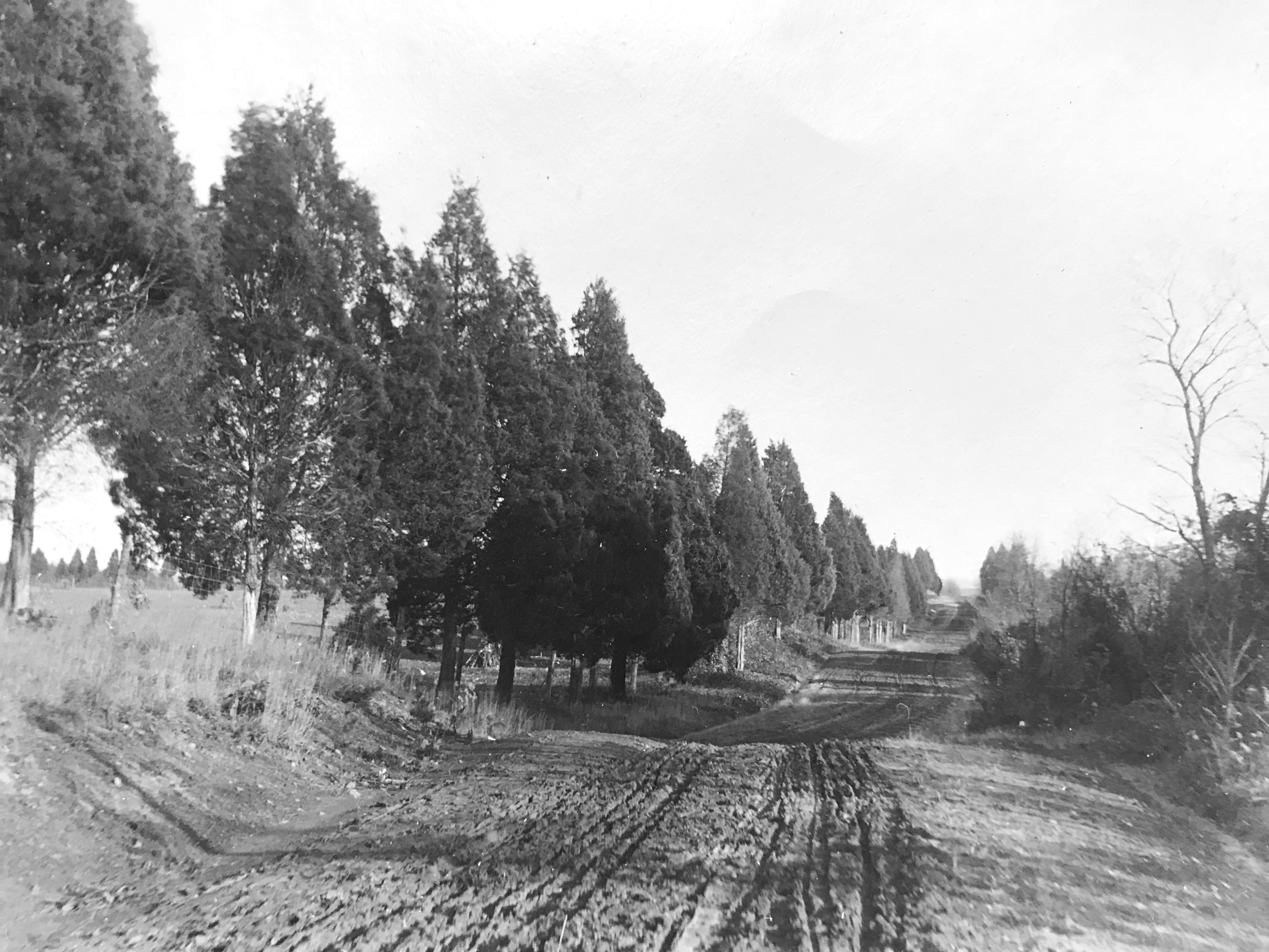
Veirs Mill Road looking east at Cedar Lane prior to paving, 1911. This roadway was not paved until 1935. Photo by Lewis Reed
Veirs Mill Road (NOW): Today, Veirs Mill Road is a four-lane divided highway. Google Map Link: https://goo.gl/maps/7uvDAWoYvwQ6KUUt9
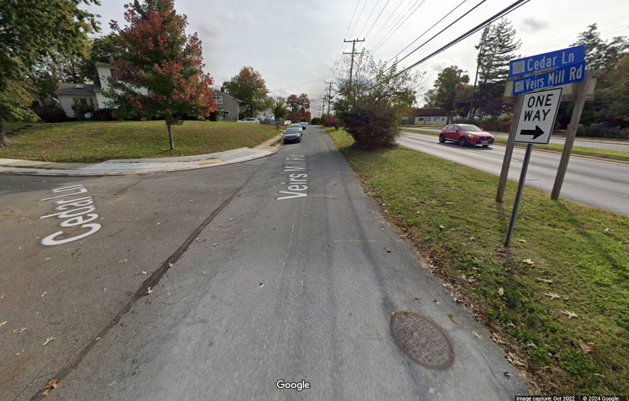
Today, Veirs Mill Road is a four-lane divided highway.

Veirs Mill Road at Cedar Lane showing deep ruts in the surface, 1911. The wagon wheels and tires of the time were very thin, and would sink straight into ruts, sometimes getting stuck. Photo by Lewis Reed.
From the “Times” (Washington):
Stalled in the mud… “Although he put on the entire 20-horsepower of his machine and called in assistance of several neighbors, it was not until shovels and crowbars had been procured to move his car… he was able to resume his journey. This experience not only caused more than an hour’s delay in reaching the city but the wear and tear on himself, those who rendered assistance, and incidentally, the machine. Thus, at least two months of the life of a $3,000 auto was spent in simply traversing a short stretch of roadway.”

A view down Cedar Lane in Bethesda, 1911. Photo by Lewis Reed.
Rockville Pike’s reputation as “one of the worst pieces of main highway in the state” eventually helped initiate Maryland’s Good Roads Movement, alongside a nationwide initiative to improve America’s roads. Responding to citizen demands, the newly created State Roads Commission incorporated the Rockville Pike into the state highway system.
In 1956, President Eisenhower passed legislation to implement (arguably) the greatest public-works project in U.S. history: the Interstate Highway System.
With this, every major city in America would be connected via highway construction, and mobility within the U.S. would ideally become limitless: a giant leap from the dirt roads and muddy paths that existed at the beginning of the century.
Find photos like these and much more on Montgomery History’s online exhibit, “Montgomery County 1900-1930: Through the Lens of Lewis Reed“.
Driving Into the 20th Century
Before 1900, there weren’t any traffic laws in regular use pertaining to automobiles other than certain regulations for the use of horse-drawn wagons and locomotives. The rise of the automobile changed all that. Local governments attempted to develop signage and laws to deal with this massive increase in the use of mechanized vehicles.

In the early 20th century, traveling cross-country by automobile was intimidating, if not a little bit dangerous. Cars were unreliable and roads were rough. The child in the photo is Lewis Reed’s daughter, Mary Jane. Photo by Lewis Reed
There were no paved highways for automobiles to shoot along at 60 and 70 miles an hour; just country roads, filled with ruts, sand, and mud, over which no one wanted to drive at the maximum speed of passenger cars, which was about 25 miles an hour.
You didn’t always need a license to drive. In fact, in the beginning of the 20th century, driver’s licenses didn’t even exist. Anyone could operate a vehicle, even if they had no idea what they were doing. As the number of automobiles increased, states slowly began to require people to be licensed in order to drive, with Maryland beginning in 1910.
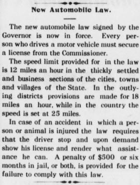
New license and speed limit laws in effect regarding automobile use for the state of Maryland. Montgomery County Sentinel, May 6, 1910.
Horses were skittish of the loud motors, and those who drove cars often had little training on how to operate them safely–both situations caused unprecedented accidents. Reed Brothers Dodge salesmen at the time often had to teach their customers how to drive the automobiles they had just purchased. “Speed limits” were a new concept, as individually-controlled vehicles capable of speeds much faster than a horse were previously non-existent.
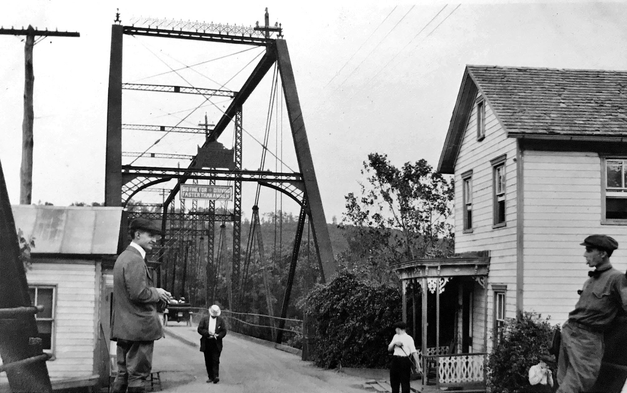
Sign on this bridge reads “$10 fine for driving faster than a walk.” Photo by Lewis Reed, c. 1910
The photograph above evokes a sense of nostalgia for slower-paced times. Literally slower: the sign over the bridge entrance reads “$10 fine for driving faster than a walk.” That’s equivalent to about $300 in today’s money.
From “Rules of the Road,” written by William P. Eno in 1903:
The mandatory registration of automobiles was one of the first traffic regulations in the United States. New York became the role model in 1901 by being the first state to require that automobile owners register their vehicles. By 1920, license plates were mandatory in all states. It took longer for the states to require a driver’s license. In 1935, there were just 39 states that issued the licenses and only a few tested applicants. Before the 1930s, most drivers received their training from automobile salesmen, nonprofit organizations such as the YMCA, family members and friends.
There was a good reason to discourage speeding in the first decades of the 1900s, as there were no stop signs, traffic lights, lane lines, brake lights, driver’s licenses, or posted speed limits, to name only a few modern safety measures. Drinking and driving? Not that big a deal. Poorly maintained roads, untrained and inexperienced drivers, and potential speeds approaching 40 mph created the perfect catalyst for horrific accidents. The photograph below illustrates how fragile those early cars were.
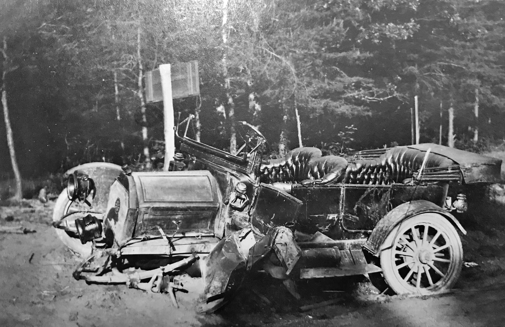
Early 20th century automobile accident. Photo by Lewis Reed
Trained as a chauffeur early in his life, Lewis Reed later leveraged his knowledge of automobiles into founding one of the longest-lived and most successful car dealerships in the state of Maryland.
Then & Now: Emmanuel Episcopal Church (Cumberland, Maryland) 1912
Cumberland is known as the “Queen City of the Alleganys.” The National Road, the Baltimore and Ohio Railroad, and the Chesapeake and Ohio Canal pass through the town, which was once an Ohio Company outpost and the westernmost part of the British Empire in North America. Cumberland has changed from a trading site to a manufacturing locality, to a tourist haven over many generations.
For this post, I have used one of Lewis Reed’s original photographs for “then” and a google stock image for “now”. Taken over 113 years apart, you can see how the Emmanuel Episcopal Church in Cumberland, Maryland looks almost the same from over a century ago.
Emmanuel Episcopal Church (THEN): The Emmanuel Episcopal Church of Cumberland, Maryland in Cumberland’s Historic District is built on the foundations of Fort Cumberland, where George Washington began his military career. Although the Emmanuel parish dates from 1803, the cornerstone of the current native sandstone building was laid in 1849 and completed in 1851.
Standing at the eastern end of the Washington Street Historic District, it is one of Maryland’s examples of early Gothic Revival architecture. The church is on the former site of Fort Cumberland, and earthwork tunnels remaining from the fort run under the church. The church was constructed around 1850 and designed by Philadelphia architect John Notman.

Emmanuel Episcopal Church Cumberland, 1912. Photo by Lewis Reed
Emmanuel Episcopal Church (NOW): Emmanuel Episcopal Church is active and continues to service the city of Cumberland. Emmanuel Church is part of the Episcopal Diocese of Maryland. The church allows self-guided tours of the stained glass; the church also offers guided tours of the tunnels. Make contact with the church in order to arrange a tour. Emmanuel Episcopal Church is part of the Washington Street Historic District, which is on the National Register of Historic Places.
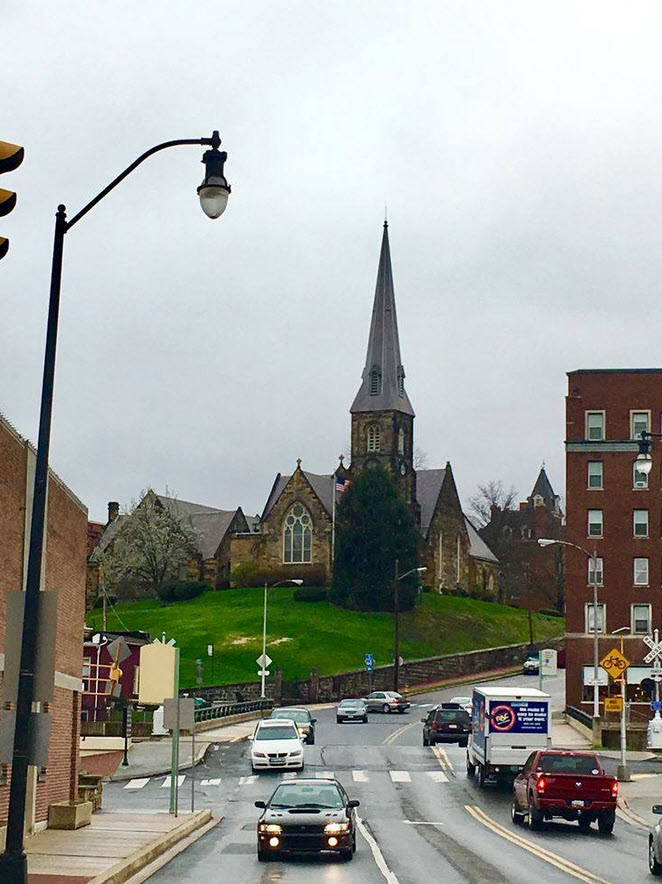
Emmanuel Episcopal Church Cumberland today. Google image.
Source: Wikipedia
Happy New Year 2025
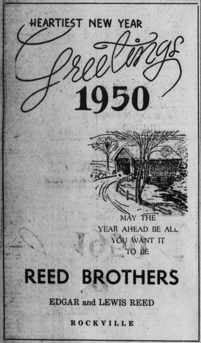
Montgomery County Sentinel. December 29, 1949
May the year ahead be all you want it to be
Books
![]()
Related Resources


Copyright Notice

Reed Brothers Dodge History (1915-2012) by Jeanne Gartner is licensed under a Creative Commons Attribution-NonCommercial 3.0 Unported License.

Recent Comments