
Snapshots in Time: Reed Brothers Dodge Then and Now
Reed Brothers Dodge occupies a distinctive place in Montgomery County’s commercial and transportation history, operating as a family-run dealership for nearly a century and weathering profound shifts in American life. Established in 1915 by automobile pioneer Lewis Reed and later joined by his brother Edgar, the firm grew from a modest Rockville garage into one of the nation’s oldest continuously operated Dodge dealerships, surviving two world wars, economic downturns, and repeated upheavals in the auto industry. “Snapshots in Time: Reed Brothers Dodge Then and Now” examines this trajectory through paired historical and contemporary images, inviting readers to view the dealership not simply as a business, but as a long-running institution that helped drive Montgomery County’s transition from rural crossroads to modern suburb. (click images to enlarge)


The black-and-white photograph on the left shows Lewis Reed’s original Rockville Garage in 1915, located at the intersection of Veirs Mill Road and Rockville Pike. In the early days of the automobile, many dealerships evolved from existing repair garages, and Rockville Garage was no exception. That same year, Lewis Reed became a partner with Robert L. and Griffith Warfield. The Warfield brothers later purchased the building in July 1915 from Lee Ricketts and Sons, who had operated the local Overland agency. The business continued under the Rockville Garage name until, shortly after Edgar Reed joined his brother, it was renamed at the suggestion of the late Judge Edward Peter.
The image on the right is a 1970 artist’s rendering of the new Reed Brothers Dodge dealership, representing a pivotal moment in the company’s history. After 55 years at the original downtown triangle location, Lee Gartner purchased 4.37 acres from Eugene Casey and relocated the business to a modern facility at 15955 Frederick Road in Rockville. Featuring a contemporary showroom and a full Dodge, Chrysler, and Jeep service complex, the new site marked the beginning of a new era, while carrying forward a legacy that began nearly six decades earlier in a modest corner garage.


The black and white photograph above, taken by Lewis Reed, shows the original Reed Brothers Dodge dealership nearly 80 years ago… and on the right is the same location today, now known as Veterans Park. In the 1970s, the site was briefly called Francis Scott Key Memorial Park, before being permanently rededicated as Veterans Park in 1988 to honor those who served. During the late 1960s, the State of Maryland acquired the property to widen Route 355. The remaining portion of land was donated to the City of Rockville, and a small street created behind the dealership was named “Dodge Street”—a lasting tribute to the more than 50 years Reed Brothers Dodge called that location home. What was once a center of automotive innovation has been transformed into a quiet place of remembrance, but the legacy of Reed Brothers Dodge remains forever etched in the street signs and stories of Rockville’s past.


These photographs show the intersection of King Farm Boulevard and Frederick Road; the site where Reed Brothers Dodge stood proudly for more than 40 years. The image on the left, captured by Google Street View in April 2012, shows the dealership just before it closed its doors for the last time.
Today, the legacy of Reed Brothers Dodge continues in a new form. On the right, the property is now home to The Reed, a rebranded apartment complex that pays tribute to the site’s deep roots in local history. In early 2025, the familiar Bainbridge name officially disappeared from 15955 Frederick Road in Rockville. Along with the signage, the apartment complex underwent a complete rebranding, now honoring the legacy of the Reed family and the dealership that once stood there. Though the building is gone, the memory of Reed Brothers Dodge remains deeply rooted in the landscape and spirit of the community.


The black and white photograph above was taken by Lewis Reed in 1915, looking west from the site of his original Rockville Garage. Visible in the image is the dealership’s very first “gas station”—a single pump. In the distance, an early trolley car makes its way along Main Street (now Rockville Pike), part of a transit line that operated from 1900 to 1935, running past Reed Brothers Dodge. Also visible in the background is the historic St. Mary’s Cemetery, a landmark that still exists today.
Fast forward to the present, and the same view seen on the right looks dramatically different. The once-quiet corridor has evolved into what locals now affectionately call “the mixing bowl,” a complex web of modern roads, traffic signals, and constant motion. While the landscape has changed, the photo offers a rare window into the early days of Rockville’s automotive and transit history.


The “then” photograph above was taken by Lewis Reed in 1953 at the corner of East Montgomery Avenue and Dodge Street. It captures the newly constructed building, which housed the showroom along with the parts and service departments. When the State of Maryland widened the surrounding roads in 1970, the connector street behind the dealership’s original location was officially named “Dodge Street,” a nod to the many years Reed Brothers Dodge operated there—from 1915 to 1970.
The “now” image on the right is a Google Maps view of the same location, captured in 2016—64 years later—showing just how dramatically the area has changed over time.


Both of the “then and now” images above are Google Maps Street View photographs taken just ten years apart. The image on the left shows Reed Brothers Dodge in 2007, while the image on the right captures the same site after its transformation into the Bainbridge Shady Grove Metro Apartments.
In early 2025, the familiar Bainbridge name officially disappeared from 15955 Frederick Road in Rockville. Along with the signage, the apartment complex underwent a complete rebranding. Today, the property is known simply as The Reed, a name that pays tribute to the site’s deep roots in local history.


The 1917 photo on the left is the original Rockville Garage located at the intersection of Veirs Mill Road and Rockville Pike, 100 years ago. Note the unpaved dirt road on Rockville Pike and trolley tracks running past the Rockville Garage. Both photographs were taken by Lewis Reed on the Rockville Pike side of the dealership.
On the right, is the same location 50 years later of the Reed Brothers Dodge Gulf Gasoline station. Due to changes in the highway, Reed Brothers began an extensive remodeling and rebuilding program. Two-thirds of the original location at the junction of then Route 240 and Veirs Mill Road was razed and a modern Gulf Service Station was erected.


On the left is a mid-1960s view from the corner of Veirs Mill Road and Dodge Street showing the new building for Reed Brothers Service Department. On the right is a Google street view image of the same location today, 50 years later.


The photograph on the left shows a side view of the Rockville Garage, including its two-story addition to the original shop, taken nearly a century ago. The first floor housed the service department, while the upper level was used for parts storage. A tall chimney, likely connected to a coal furnace, provided heat, and the abundance of windows flooded the workspace with natural light for servicing early automobiles. By this time, Firestone Tire signage had replaced the earlier Fisk brand sold at Rockville Garage in 1915.
The photograph on the right was taken in 1968 from the same location, roughly 50 years later. By then, major highway changes had dramatically altered the site. Nearly two-thirds of the original property at the junction of what was then Route 240 and Veirs Mill Road had been razed, making way for a modern Gulf service station.


The beginning and the end at 15955 Frederick Road: 1970 and 2013.
The photograph on the left shows the dealership’s newly completed building in 1970, following its move from the original location at the triangle formed by Veirs Mill Road and Rockville Pike. This modern facility marked Reed Brothers Dodge’s 55th year of selling Dodge vehicles and signaled a new chapter for the business.
The image on the right was taken on May 16, 2013. The building stands vacant, photographed on the very day demolition began, bringing nearly a century of automotive history at this location to a close.


The photograph on the left shows rows of beige and baby-blue cars lined up neatly in the side lot. Just across the road stands King Farm, dominated by its large barn painted with the words “Milk for Thompson’s Dairy,” long before the land was transformed into a dense mixed-use community. At the time, Lawson King’s dairy cows grazed in fields only a few feet from the roadway. At its height, King Farm was the area’s largest milk producer and had remained in agricultural use for nearly 75 years before development was approved in 1996.
The image on the right was taken from the same vantage point in 2009, more than three decades later. The familiar barn still rises in the background, but the surrounding fields are gone, replaced by the streets, buildings, and neighborhoods of what is now known as King Farm.
Looking at these images side by side, it’s clear that progress doesn’t erase history, it builds on it. Streets may widen, buildings may disappear, and businesses may move on, but traces of what once was are still there for those who know where to look. Lewis Reed’s photographs give us a rare anchor to the past, allowing today’s landscape to be seen with new eyes. In comparing then and now, we’re reminded that Rockville’s story is not just about change, but about continuity, memory, and the people who lived and worked along these streets long before us.
Braddock Heights, Maryland Then & Now
Looking at old photographs is like opening a window to the past. They invite us to step back in time, sparking both wonder and amazement at how much the world around us has changed. For this post, I’ve paired one of Lewis Reed’s original photographs for the “then” view with a modern Google image for the “now.”
Braddock Heights (THEN): Braddock Heights is a small unincorporated community in Frederick County, Maryland, established around the turn of the 20th century as a popular mountain resort. In its early days, it offered visitors hotels, an amusement park, a skating rink, nature trails, and an observatory from which four states (Maryland, Pennsylvania, Virginia, and West Virginia) could be seen. It even boasted a small ski resort. The Hagerstown and Frederick Railway operated a trolley line connecting Frederick and Braddock Heights from 1896 to 1946. Today, with a population of about 5,000, the area remains known for its sweeping views of Frederick and the Monocacy and Middletown valleys. Braddock Heights takes its name from British General Edward Braddock (1695-1755), who passed through the region during the French and Indian War on April 29, 1755.
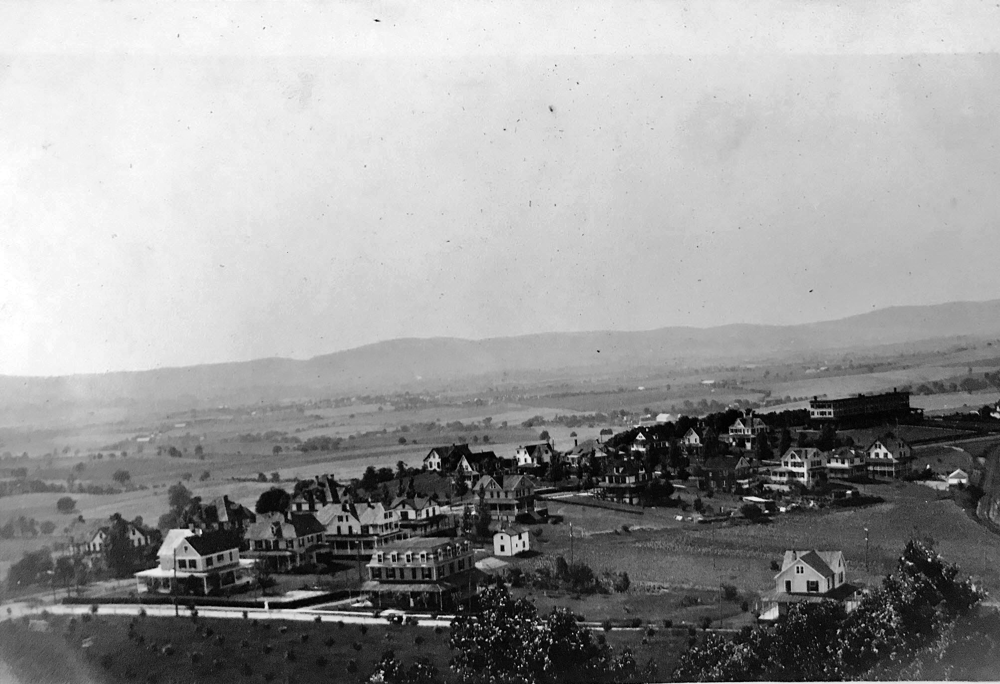
Braddock Heights viewed from the Observatory, with Middletown visible in the distance. Photograph by Lewis Reed, circa 1910.
Braddock Heights (NOW): Today, rush-hour traffic flows over the mountain along Alternate U.S. Route 40, stretching from Frederick and I-70 into the Middletown Valley, most of it passing right by the stone pillars at Maryland Avenue that mark the entrance to Braddock Heights.
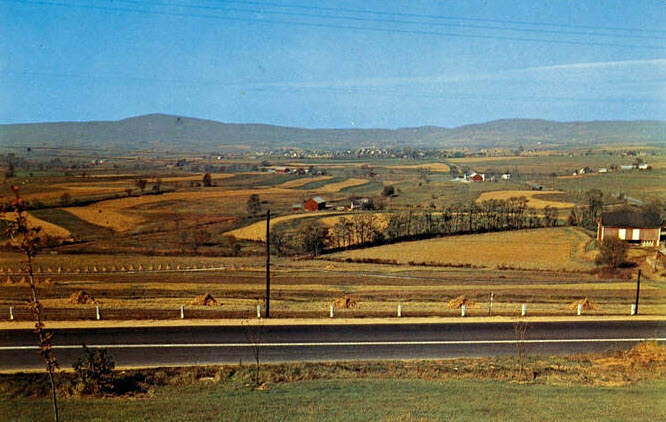
View overlooking Middletown Valley along U.S. Route 40
Local Folklore: Fun Trivia about the Snallygaster
The Snallygaster is a legendary creature rooted in Maryland folklore, particularly in Frederick County and the Middletown Valley. Originating from the German settlers in the 1730s who called it a Schneller Geist meaning “quick spirit,” this fearsome beast is described as a half-bird, half-reptile chimera with razor-sharp teeth and sometimes octopus-like tentacles. The Snallygaster is said to silently swoop down from the sky, preying on livestock and occasionally people, with some early tales even claiming it sucked the blood of its victims.
In the early 1900s, the creature gained widespread notoriety through newspaper reports depicting it with enormous wings, a long pointed bill, steel-hook claws, and a single eye in the middle of its forehead, emitting screeches like a locomotive whistle. The creature was so infamous that the Smithsonian Institution reportedly offered a reward for its hide, and President Theodore Roosevelt considered hunting it himself.
Local farms still bear seven-pointed stars painted on barns, believed to be protective symbols meant to keep the Snallygaster at bay. Beyond scary stories, the legend has evolved into a cultural symbol celebrated today with events like the annual Snallygaster Festival in Frederick County, highlighting the area’s rich folklore heritage.
Though some of its tales have troubling historical contexts, including the use of the legend to instill fear in certain communities during segregation, the Snallygaster remains a memorable and intriguing figure in Maryland’s folklore landscape, blending myth, mystery, and history in one creature.
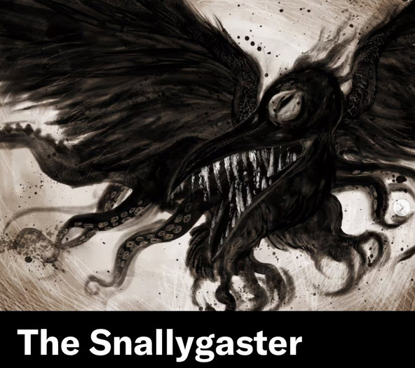
Maryland’s legendary winged beast—half bird, half reptile.
Then and Now: Commander Hotel Ocean City MD 1930
Few hotels in Ocean City can celebrate continually trading for over 90 years. The family owners can trace their local history back over 200 years. There have been many changes in the world of travel at that time, but The Commander’s beachfront boardwalk location remains as special today as it was on the day it all began.
Commander Hotel (THEN): The Commander Hotel first opened on Memorial Day in 1930, offering 62 rooms, a full American Plan dining room, and a kitchen equipped with wood-burning stoves. The hotel featured the city’s first elevator, in-room telephone service, and both ocean and boardwalk-facing front porch with rocking chairs. During the World War II era, the hotel welcomed doctors, lawyers, and executives. Each room was equipped with blackout curtains for use at night, which protected the windows from enemy shelling from offshore submarines.

Commander Hotel on the boardwalk at Ocean City, Maryland. Photo by Lewis Reed, ca. 1930
Commander Hotel (NOW): The same view today. The Commander Hotel was, for a long time, the northernmost hotel on the Boardwalk. Its dining room was famous and the Commander outranked many other hotels, enjoying “elite” status. The facility underwent a two-stage renovation in 1979, and in 1992 the cabanas near the pool were rebuilt. The original structure was razed in 1997 and the current eight-story Commander was constructed on the 14th Street site the following year.

Commander Hotel today
Then & Now: The New Raleigh Hotel Washington DC, 1912
Some of the city’s oldest hotels not only have a long history of storied visitors and impressive tales, but they’ve shaped the city’s landscape for decades and perhaps centuries. However, for every Hay-Adams, Willard Continental and Morrison-Clark, there’s a hotel like the the Raleigh Hotel that’s either been converted and or destroyed entirely.
Raleigh Hotel (THEN): Along with the Willard, the Raleigh Hotel was one of the largest and grandest hotels in Washington in the first part of the twentieth century. It held a commanding position on Pennsylvania Avenue across from the Old Post Office Building and was famous as a Mecca for patrons of the performing arts. In 1911, the building was razed and rebuilt as a 13-story Beaux Arts hotel.
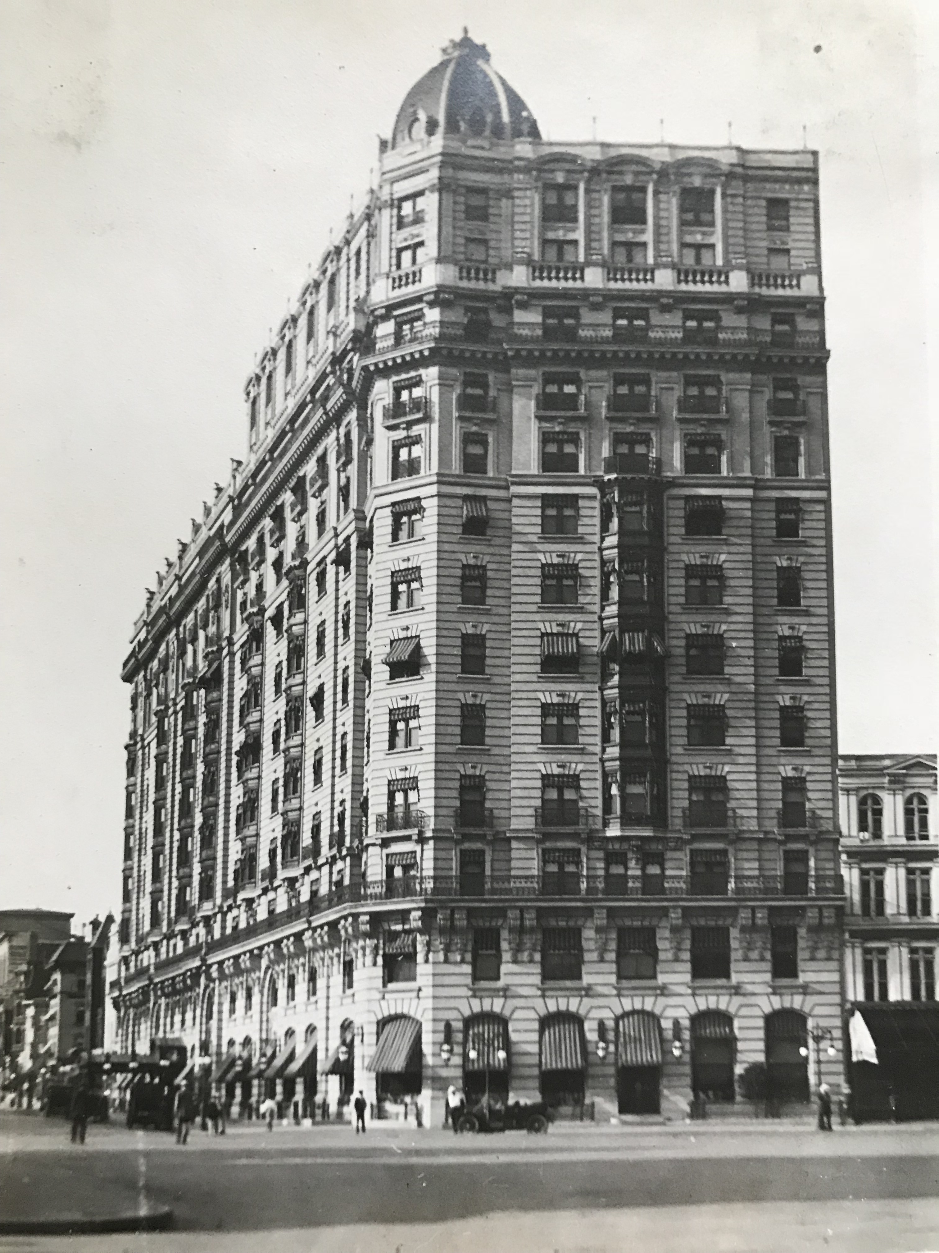
The recently completed Raleigh Hotel at Pennsylvania Ave and 12th Street NW, built on the site of the previous Raleigh Hotel. Photo taken by Lewis Reed, ca. 1912
Raleigh Hotel (NOW): The hotel closed in 1963, its furnishings were sold off, and it was demolished a year later. Its replacement, a 14-story office building at 1111 Pennsylvania Avenue, was completed in 1968, and it still stands on the site today.

The site of the Raleigh as it appears today.
Then & Now: Monrovia Post Office
This post is a continuation of a series of “Then & Now” images from Lewis Reed’s Photo Collection alongside photographs of how they appear today. Lewis Reed worked hard to preserve a visual history of Montgomery County, Maryland and surrounding areas long before automobiles were even around. As early as 1905, he toured on his motorcycle across the states of Maryland, Virginia, and Washington, D.C. and took photographs of many historic locations. Taken approximately 114 years apart, you can see how the Post Office of Monrovia Maryland looks almost the same from over a century ago.
Monrovia Post Office (THEN): On November 15, 1901, the Monrovia Post Office was one of the first places in the U.S. to participate in the Rural Free Delivery (RFD) experiment established by the U.S. Post Office. RFD was established on an experimental basis in 1896. In 1902, it became an official part of the Post Office Department’s services.
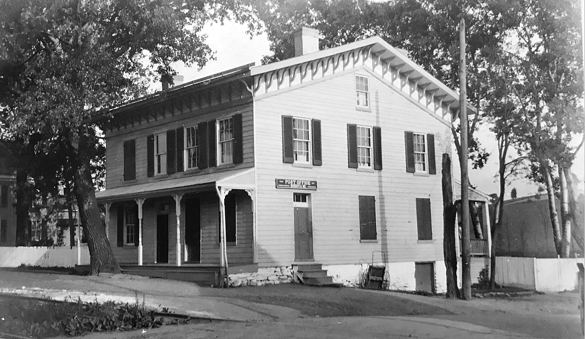
Monrovia Post Office, 1910. Photo by Lewis Reed
Monrovia Post Office (NOW): The little village of Monrovia is today not much more than an underpass, a post office, and a few abandoned buildings. The old post office building is now an Office Park area in Monrovia.
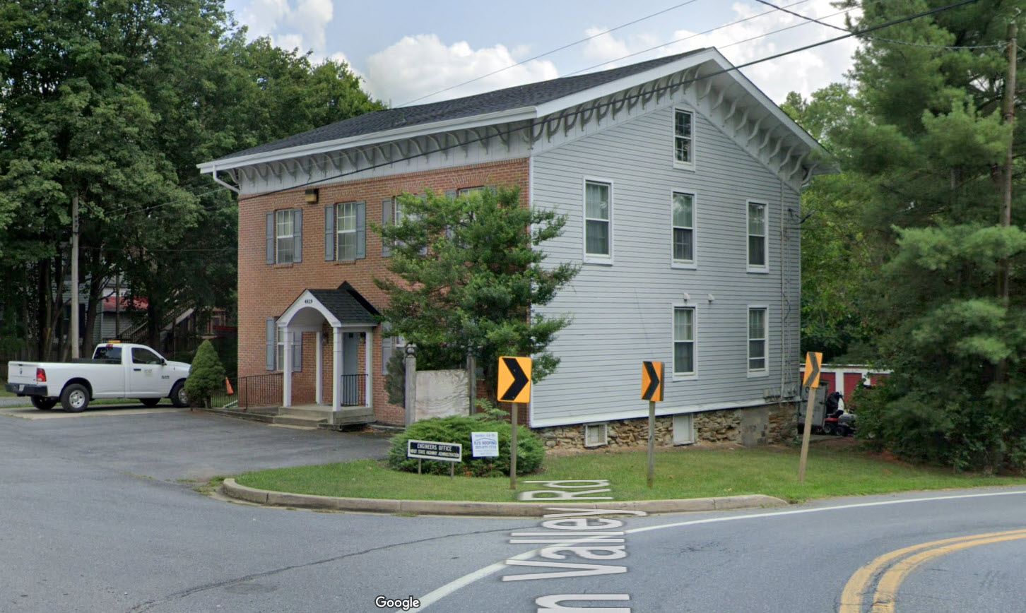
This google image of Monrovia Post Office today is still very recognizable.
Source: Wikipedia
First RDF Maryland
Books
![]()
Related Resources


Copyright Notice

Reed Brothers Dodge History (1915-2012) by Jeanne Gartner is licensed under a Creative Commons Attribution-NonCommercial 3.0 Unported License.

Recent Comments