
Historic Tracks: Gettysburg Lincoln Railroad Station Then and Now
The Gettysburg Lincoln Railroad Station is more than just a building, it’s a piece of American history. From Abraham Lincoln’s famous journey to deliver the Gettysburg Address to the thousands of visitors who pass through today, this station has seen it all. In this “Then & Now” post, we take a look at how this iconic landmark has changed (or stayed the same!) over the years, giving us a fresh perspective on a place that helped shape our nation’s story.
Gettysburg Lincoln Railroad Station (THEN): Captured by photographer Lewis Reed in 1914, this remarkable image shows a crowd gathered along the tracks outside the Gettysburg Lincoln Railroad Station. The station’s elegant Italianate architecture with its arched windows, decorative brickwork, and central cupola stands prominently in the background. A steam locomotive waits at the platform as men in suits and bowler hats fill the scene, evoking an era when rail travel was both essential and ceremonial. The photograph offers a vivid glimpse into early 20th-century life in Gettysburg, when the railroad still served as the town’s vital connection to the wider world.
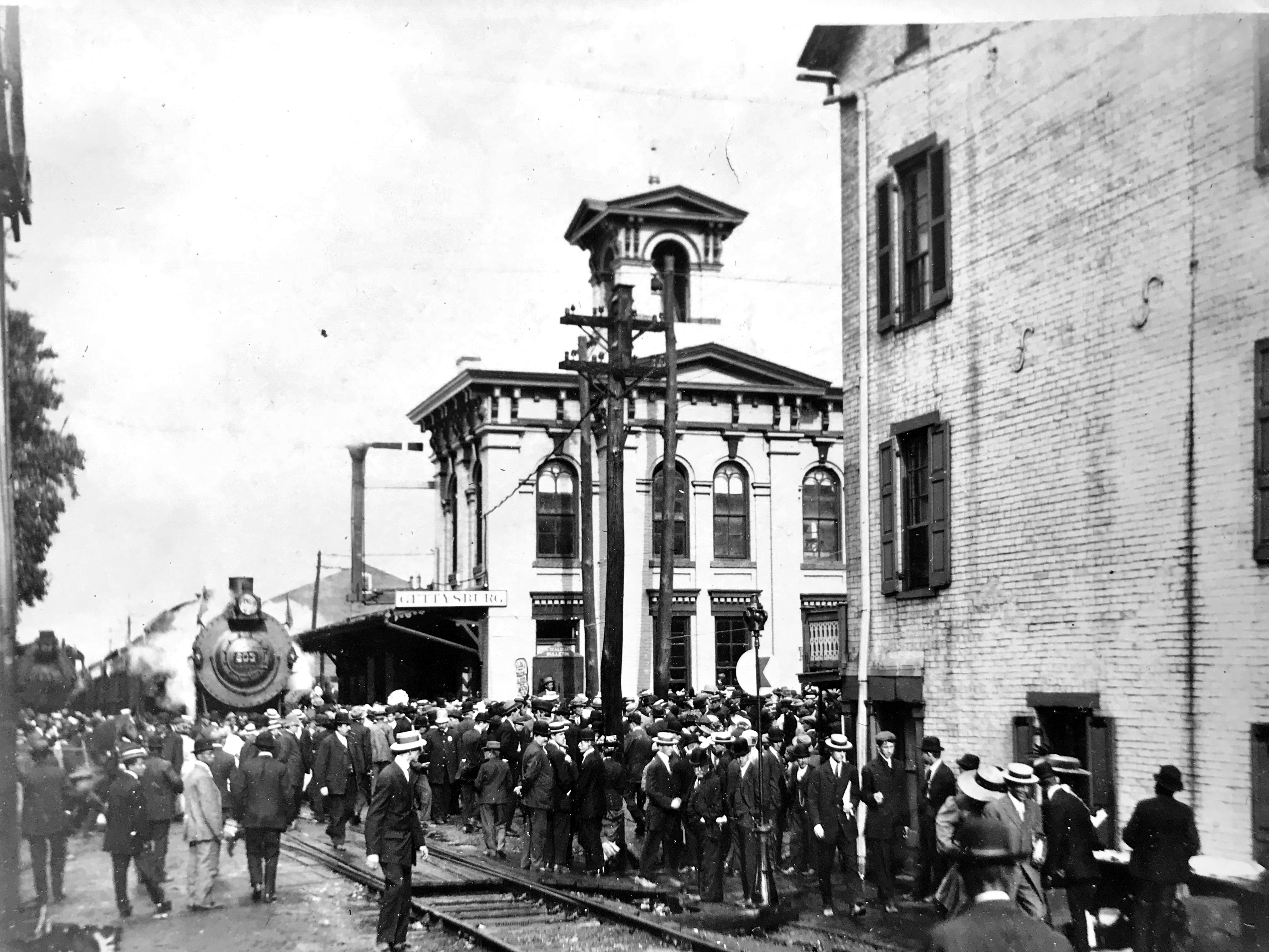
A historic photograph of the Gettysburg Lincoln Railroad Station captured by Lewis Reed in 1914, showing the depot in its early 20th-century setting.
Gettysburg Lincoln Railroad Station (NOW): More than a century later, the restored Gettysburg Lincoln Railroad Station continues to welcome visitors; though today, they come not to board trains, but to step back in time. The station now operates as a museum and visitor center, preserving the story of Abraham Lincoln’s arrival to deliver the Gettysburg Address in 1863. Its beautifully restored façade and carefully maintained details honor both its Civil War legacy and the generations that followed, ensuring this historic landmark remains a lasting link between past and present.
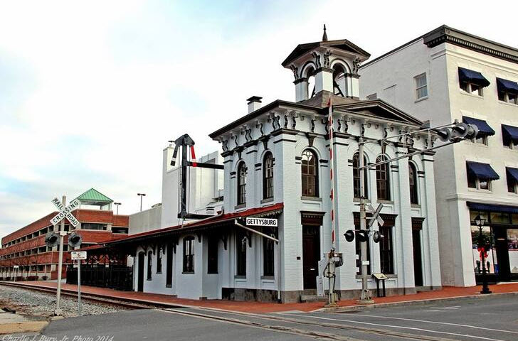
Gettysburg Railroad Lincoln Train Museum Today
Harvesting History: Pumpkin Picking in Pleasant Hills, 1920

Pumpkin picking in Thomas Kelly’s Pumpkin Patch, Darnestown, Maryland circa. early 1900s. Photo by Lewis Reed
Captured in this rare photograph are three men dressed in suits, standing among the pumpkins grown by farmer Thomas Kelly in Pleasant Hills, dating back to the early 1900s. This image provides a unique window into the rural life of Montgomery County, where farming and the seasonal rhythm of the land shaped the community’s way of life.
Thomas Kelly was a prominent figure who cultivated much of the land near the Pleasant Hills homestead. He was widely known for his “Kelly Corn” wagon, a summer staple stocked with fresh dairy products and vegetables, which traveled the local roads. Every August, his corn also played a key role in feeding attendees at the Montgomery County Fair, a popular local event.
As autumn rolled in, Kelly’s farm transformed into a vibrant pumpkin patch where locals and visitors came to select pumpkins for their homes. The tradition of pumpkin picking was not only about gathering produce but also experienced as an annual celebration of the harvest season. This photograph recalls that special connection to the land and the traditions that brought people together year after year.
Photographer Lewis Reed, the founder of Reed Brothers Dodge, captured moments like these that preserve the character and heritage of Montgomery County’s agricultural past. This image remains a poignant reminder of simpler times grounded in community, hard work, and seasonal bounty.
A Century in Contrast: Then & Now at the Conowingo Dam
As part of our ongoing “Then & Now” series, we’re journeying through time using photographs from Lewis Reed’s remarkable photo collection. These powerful comparisons highlight how much, and sometimes how little, the world around us has changed. In this installment, we turn our lens to the Conowingo Dam, where echoes of the past still linger in the present. Step back in time and see how this historic site has evolved over the past 100 years.
Conowingo Dam (THEN): The Conowingo Dam, completed in 1928, is a large hydroelectric dam on the Susquehanna River in Maryland, known for its role in power generation and its impact on the Chesapeake Bay. When completed, it was the second-largest hydroelectric project by power output in the United States, after Niagara Falls.
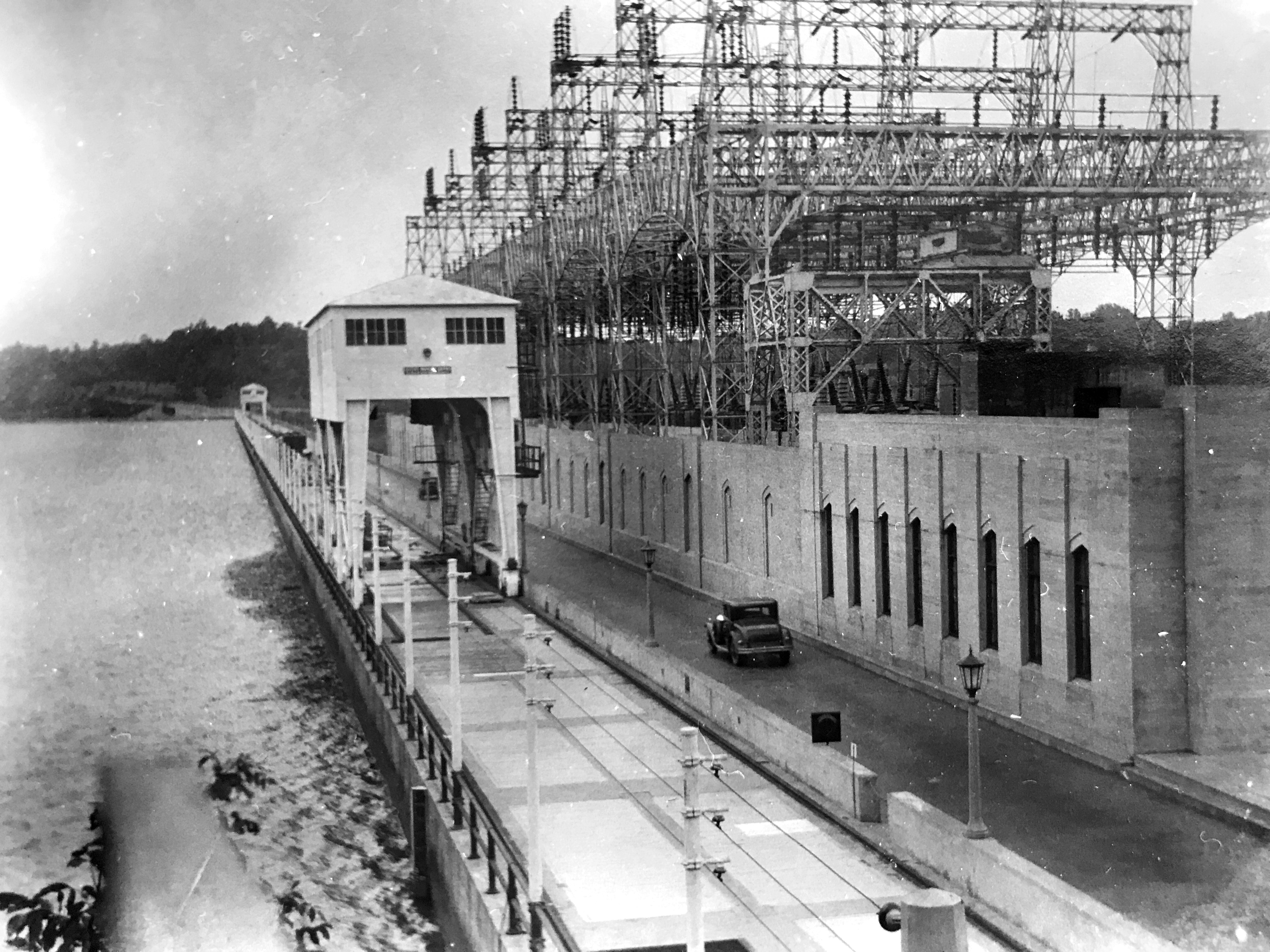
Power House and entrance to driveway crossing Conowingo Dam, Conowingo, Maryland. Photo by Lewis Reed, ca. 1928.
Conowingo Dam (NOW): Today, the Conowingo Dam is operated by the Susquehanna Electric Company, a part of Constellation Energy. The dam is one of the most popular destinations in the United States for seeing bald eagles. While the surrounding area is home to dozens of the eagles year-round, upwards of 200 more will migrate from places like New York and Canada, where lakes and rivers freeze over in the winter and limit fishing opportunities. Their numbers typically peak from November to January, with the eagles taking advantage of the dam’s turbines stunning fish swimming downriver to make for easy hunting. Once a fish is caught, eagles will often battle midair for it, and the spectacle attracts bird photographers from all over the world.
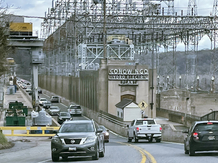
Conowingo Dam today. Google stock image
Source of Information: Conowingo Dam – Wikipedia
The MCPD Motor Unit: 103 Years of Law Enforcement on Two Wheels

This is the first known photograph of the entire Montgomery County Police Force Motor Unit. Pictured left to right: Earl Burdine, Lawrence Clagett, Guy Jones, Chief Charles Cooley, Leroy Rodgers, and Oscar Gaither. Photo taken by Lewis Reed on July 4, 1922.
July 4th marks the 103rd anniversary of the beginning of the Montgomery County Police Department. Cattle rustling, bootlegging and stealing poultry were among the most common crimes when Montgomery County hired its first police chief and five officers in July 1922. So widespread was the theft of chickens and turkeys that some residents employed a homespun form of crime prevention by cutting off a specific claw on their birds to identify them. “Officers knew who all the chicken thieves were,” said one historical account of the era put together by the police department, “and upon getting a report of missing Rhode Island Reds, or some other breed, would head straight for the thieves’ hideaway to try to catch them ‘red handed’ before the birds got to the frying pan.”
Posing in front of Reed Brothers Dodge on July 4, 1922 Chief Charles Cooley, center, and his men of the first mounted unit of the Montgomery County Police Force, were on their first day of duty. For several years, since there was no police station, the officers would meet for “roll call” on the steps of the Red Brick Courthouse in Rockville at 2:00 p.m. every day to let each other know they were alive and well. Chief Cooley was given the privilege of a Model T Ford. The chief was paid $1,800 a year while the officers got $1,500. Each of the officers was issued a Harley-Davidson motorcycle, a .38 Smith & Wesson handgun, a black jack, law book and was allotted $300.00 a year for the upkeep of their motorcycle. Jones patrolled Silver Spring, Rodgers the Bethesda-Chevy Chase area and Burdine, Clagett and Gaither the Upper County areas.
The county’s population in the early 1920s was just 35,000 (it’s now estimated at more than 1M). Much of the county was farmland, which accounted for the thefts of livestock. It also was the Prohibition era, when bootlegging and moonshine still factored routinely on an officer’s shift.
The officers worked 14 hours at night, 10 hours in the day, with two days off every two weeks. But they were on call at all times. Since there was no mobile radio contact (the first one-way radio system was installed in cars in the early 1930s), the officers tended to hang around the courthouse or a local firehouse that had a phone.
One of the officers came up with the idea of placing a flashing red beacon light on a pole atop the Rockville courthouse. When flashing, it would alert police that they had a call or were wanted at the office. In 1927, similar lights were used at district stations in Silver Spring and Bethesda.
Today, more than 1,300 sworn officers assisted by 600 support personnel provide full service to a large suburban county with over one million people.
Congratulations MCPD and thank you for your many years of service!
Featured Photo: Memorial Day in Gettysburg, A Historic Tradition

Women and children reverently carry bouquets to lay upon the graves in the cemetery. Photo by Lewis Reed, ca. early 1900s.
Memorial Day in Gettysburg holds a significant place in American history, marked by a long-standing tradition of remembrance and commemoration. The Memorial Day parade and ceremony in Gettysburg is recognized as one of the oldest continuously held ceremonies in the United States. A poignant visual record of this tradition is captured in the photograph taken by Lewis Reed. This image depicts local women and children walking en route to the Soldiers National Cemetery to lay flowers. This act of laying flowers is a symbolic gesture of remembrance, a practice that continues to this day.
Gettysburg National Cemetery is the final resting place for 3,512 Union soldiers. This cemetery is not only a burial ground, but also a site of historical significance, as it is where President Abraham Lincoln delivered his iconic Gettysburg Address in 1863.
Books
![]()
Related Resources


Copyright Notice

Reed Brothers Dodge History (1915-2012) by Jeanne Gartner is licensed under a Creative Commons Attribution-NonCommercial 3.0 Unported License.

Recent Comments