
Braddock Heights, Maryland Then & Now
Looking at old photographs is like opening a window to the past. They invite us to step back in time, sparking both wonder and amazement at how much the world around us has changed. For this post, I’ve paired one of Lewis Reed’s original photographs for the “then” view with a modern Google image for the “now.”
Braddock Heights (THEN): Braddock Heights is a small unincorporated community in Frederick County, Maryland, established around the turn of the 20th century as a popular mountain resort. In its early days, it offered visitors hotels, an amusement park, a skating rink, nature trails, and an observatory from which four states (Maryland, Pennsylvania, Virginia, and West Virginia) could be seen. It even boasted a small ski resort. The Hagerstown and Frederick Railway operated a trolley line connecting Frederick and Braddock Heights from 1896 to 1946. Today, with a population of about 5,000, the area remains known for its sweeping views of Frederick and the Monocacy and Middletown valleys. Braddock Heights takes its name from British General Edward Braddock (1695-1755), who passed through the region during the French and Indian War on April 29, 1755.
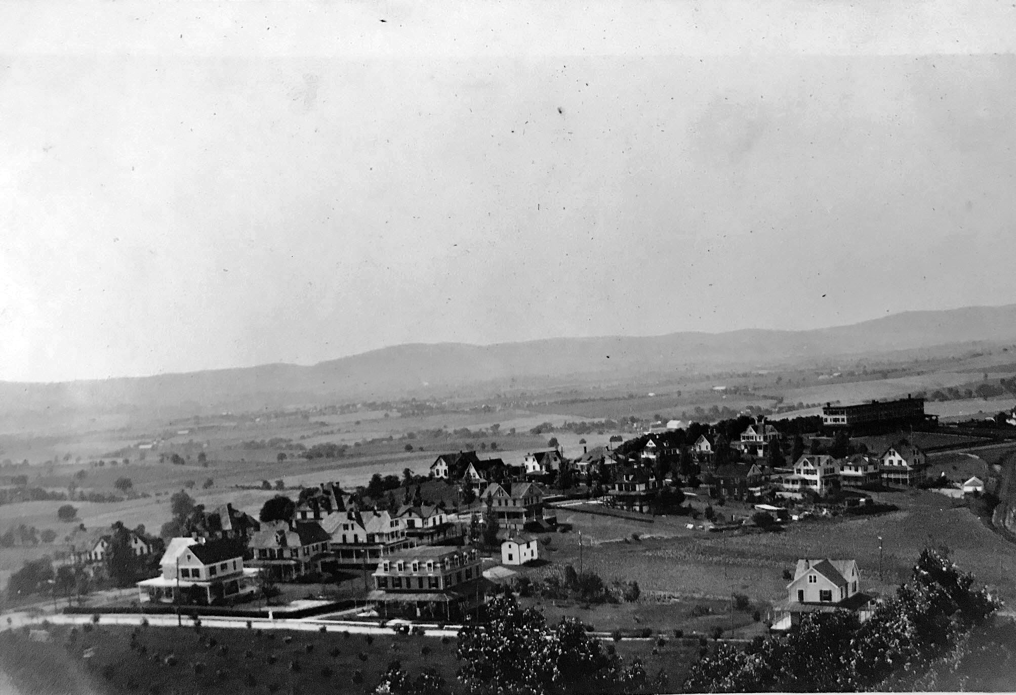
Braddock Heights viewed from the Observatory, with Middletown visible in the distance. Photograph by Lewis Reed, circa 1910.
Braddock Heights (NOW): Today, rush-hour traffic flows over the mountain along Alternate U.S. Route 40, stretching from Frederick and I-70 into the Middletown Valley, most of it passing right by the stone pillars at Maryland Avenue that mark the entrance to Braddock Heights.
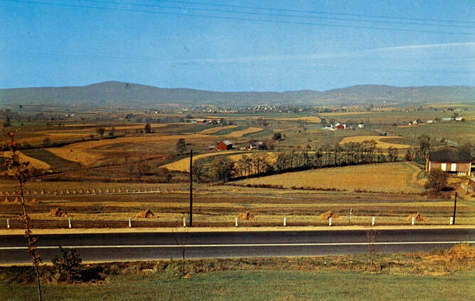
View overlooking Middletown Valley along U.S. Route 40
Local Folklore: Fun Trivia about the Snallygaster
The Snallygaster is a legendary creature rooted in Maryland folklore, particularly in Frederick County and the Middletown Valley. Originating from the German settlers in the 1730s who called it a Schneller Geist meaning “quick spirit,” this fearsome beast is described as a half-bird, half-reptile chimera with razor-sharp teeth and sometimes octopus-like tentacles. The Snallygaster is said to silently swoop down from the sky, preying on livestock and occasionally people, with some early tales even claiming it sucked the blood of its victims.
In the early 1900s, the creature gained widespread notoriety through newspaper reports depicting it with enormous wings, a long pointed bill, steel-hook claws, and a single eye in the middle of its forehead, emitting screeches like a locomotive whistle. The creature was so infamous that the Smithsonian Institution reportedly offered a reward for its hide, and President Theodore Roosevelt considered hunting it himself.
Local farms still bear seven-pointed stars painted on barns, believed to be protective symbols meant to keep the Snallygaster at bay. Beyond scary stories, the legend has evolved into a cultural symbol celebrated today with events like the annual Snallygaster Festival in Frederick County, highlighting the area’s rich folklore heritage.
Though some of its tales have troubling historical contexts, including the use of the legend to instill fear in certain communities during segregation, the Snallygaster remains a memorable and intriguing figure in Maryland’s folklore landscape, blending myth, mystery, and history in one creature.
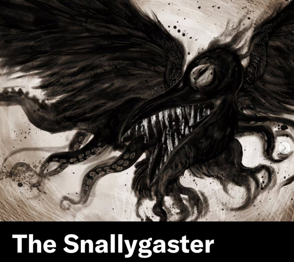
Maryland’s legendary winged beast—half bird, half reptile.
A Century in Contrast: Then & Now at the Conowingo Dam
As part of our ongoing “Then & Now” series, we’re journeying through time using photographs from Lewis Reed’s remarkable photo collection. These powerful comparisons highlight how much, and sometimes how little, the world around us has changed. In this installment, we turn our lens to the Conowingo Dam, where echoes of the past still linger in the present. Step back in time and see how this historic site has evolved over the past 100 years.
Conowingo Dam (THEN): The Conowingo Dam, completed in 1928, is a large hydroelectric dam on the Susquehanna River in Maryland, known for its role in power generation and its impact on the Chesapeake Bay. When completed, it was the second-largest hydroelectric project by power output in the United States, after Niagara Falls.
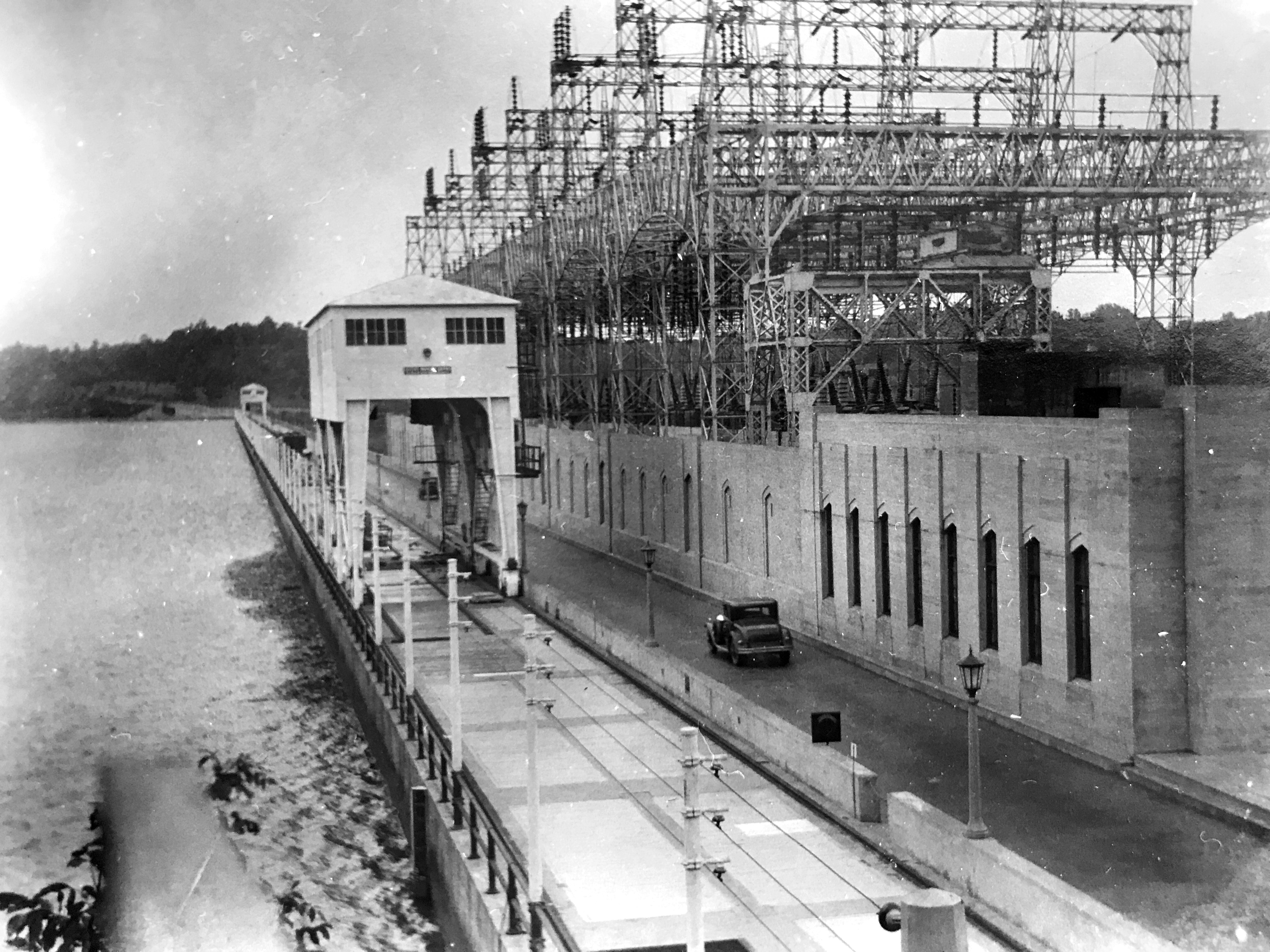
Power House and entrance to driveway crossing Conowingo Dam, Conowingo, Maryland. Photo by Lewis Reed, ca. 1928.
Conowingo Dam (NOW): Today, the Conowingo Dam is operated by the Susquehanna Electric Company, a part of Constellation Energy. The dam is one of the most popular destinations in the United States for seeing bald eagles. While the surrounding area is home to dozens of the eagles year-round, upwards of 200 more will migrate from places like New York and Canada, where lakes and rivers freeze over in the winter and limit fishing opportunities. Their numbers typically peak from November to January, with the eagles taking advantage of the dam’s turbines stunning fish swimming downriver to make for easy hunting. Once a fish is caught, eagles will often battle midair for it, and the spectacle attracts bird photographers from all over the world.
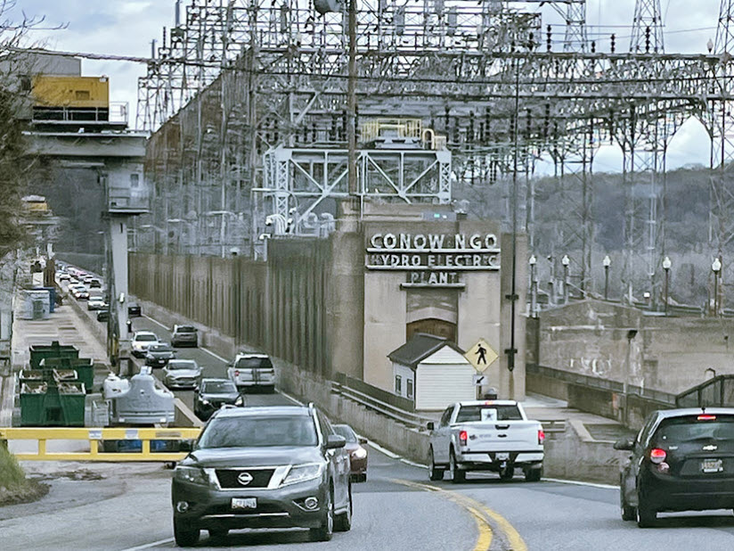
Conowingo Dam today. Google stock image
Source of Information: Conowingo Dam – Wikipedia
Then & Now: The Original 1917 Rockville Garage
Reed Brothers Dodge and the surrounding area sure has changed a lot in its almost century-long history. You might not realize how much things have changed until you look back and see what it looked like in the past. For this post, I have used one of Lewis Reed’s original photographs for “then” and a Google Maps street view image from today for “now”.

1917 view of the original Rockville Garage two-story addition. Until 1920, Dodge sported a set of six hexagonal windows in the back of each passenger cabin on their Touring and Roaster models. These were called cathedral lights and became the first trademark feature to make Dodge vehicles stand out from the rest. Parked in front is an early Dodge car with the exclusive Dodge Brothers cathedral-style rear curtain windows.
NOW: The color photograph below, is the dealership’s location today, now known as Veterans Park. In the 1970s the site was known as the Francis Scott Key Memorial Park, and later in 1988, it was permanently rededicated as Veterans Park. In the late 1960s, the state of Maryland acquired the land to widen 355 and donated the remaining sliver to the City. The connector street behind the dealership’s original location was named “Dodge Street” by the State of Maryland following the dealership’s 1941 expansion. Dodge Street today is one of the shortest roads in the State of Maryland, running between the Rockville Pike (at Richard Montgomery High School) and Veirs Mill Road, a distance of only 250 feet.

Rockville Garage (Reed Brothers Dodge) original location at the triangle today. Google Image Capture, 2021
Then and Now: Commander Hotel Ocean City MD 1930
Few hotels in Ocean City can celebrate continually trading for over 90 years. The family owners can trace their local history back over 200 years. There have been many changes in the world of travel at that time, but The Commander’s beachfront boardwalk location remains as special today as it was on the day it all began.
Commander Hotel (THEN): The Commander Hotel first opened on Memorial Day in 1930, offering 62 rooms, a full American Plan dining room, and a kitchen equipped with wood-burning stoves. The hotel featured the city’s first elevator, in-room telephone service, and both ocean and boardwalk-facing front porch with rocking chairs. During the World War II era, the hotel welcomed doctors, lawyers, and executives. Each room was equipped with blackout curtains for use at night, which protected the windows from enemy shelling from offshore submarines.

Commander Hotel on the boardwalk at Ocean City, Maryland. Photo by Lewis Reed, ca. 1930
Commander Hotel (NOW): The same view today. The Commander Hotel was, for a long time, the northernmost hotel on the Boardwalk. Its dining room was famous and the Commander outranked many other hotels, enjoying “elite” status. The facility underwent a two-stage renovation in 1979, and in 1992 the cabanas near the pool were rebuilt. The original structure was razed in 1997 and the current eight-story Commander was constructed on the 14th Street site the following year.

Commander Hotel today
Then & Now: Veirs Mill Road, 1911
Do you recognize the road pictured below? Few modern residents of Montgomery County would guess, but it is a shot of Veirs Mill Road before it was paved.
Veirs Mill Road (THEN): In the early 19th century, rural roads were often little more than muddy trails. The popularity of the car coincided with the improvement of public roads around Rockville. By 1929, when Montgomery County residents owned 13,000 cars, Rockville Pike and Montgomery Avenue had both been paved, but the less-traveled Veirs Mill Road remained a narrow dirt road for decades after that. By the end of 1935, the highway was paved as a macadam road. Today, Veirs Mill Road is a four-lane divided highway.
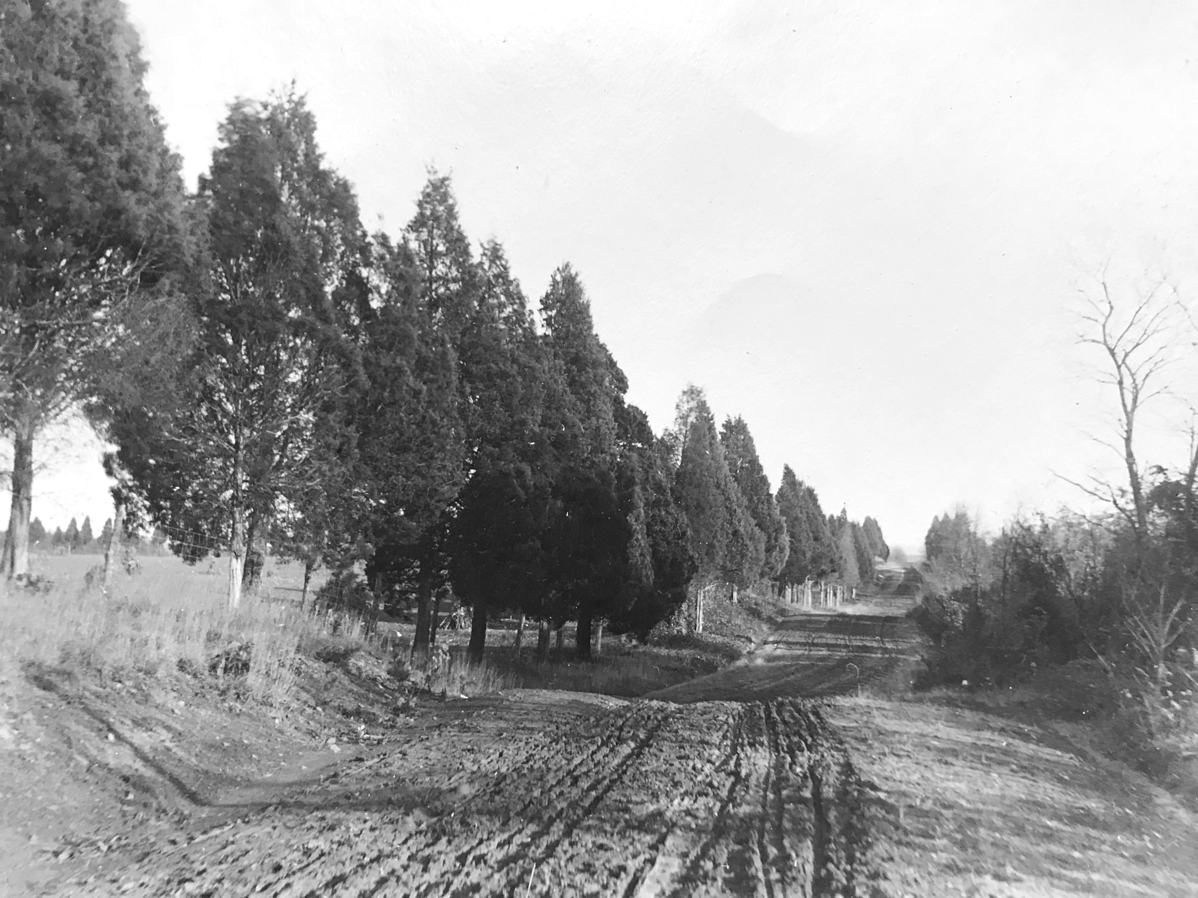
Veirs Mill Road looking east at Cedar Lane prior to paving, 1911. This roadway was not paved until 1935. Photo by Lewis Reed
Veirs Mill Road (NOW): Today, Veirs Mill Road is a four-lane divided highway. Google Map Link: https://goo.gl/maps/7uvDAWoYvwQ6KUUt9
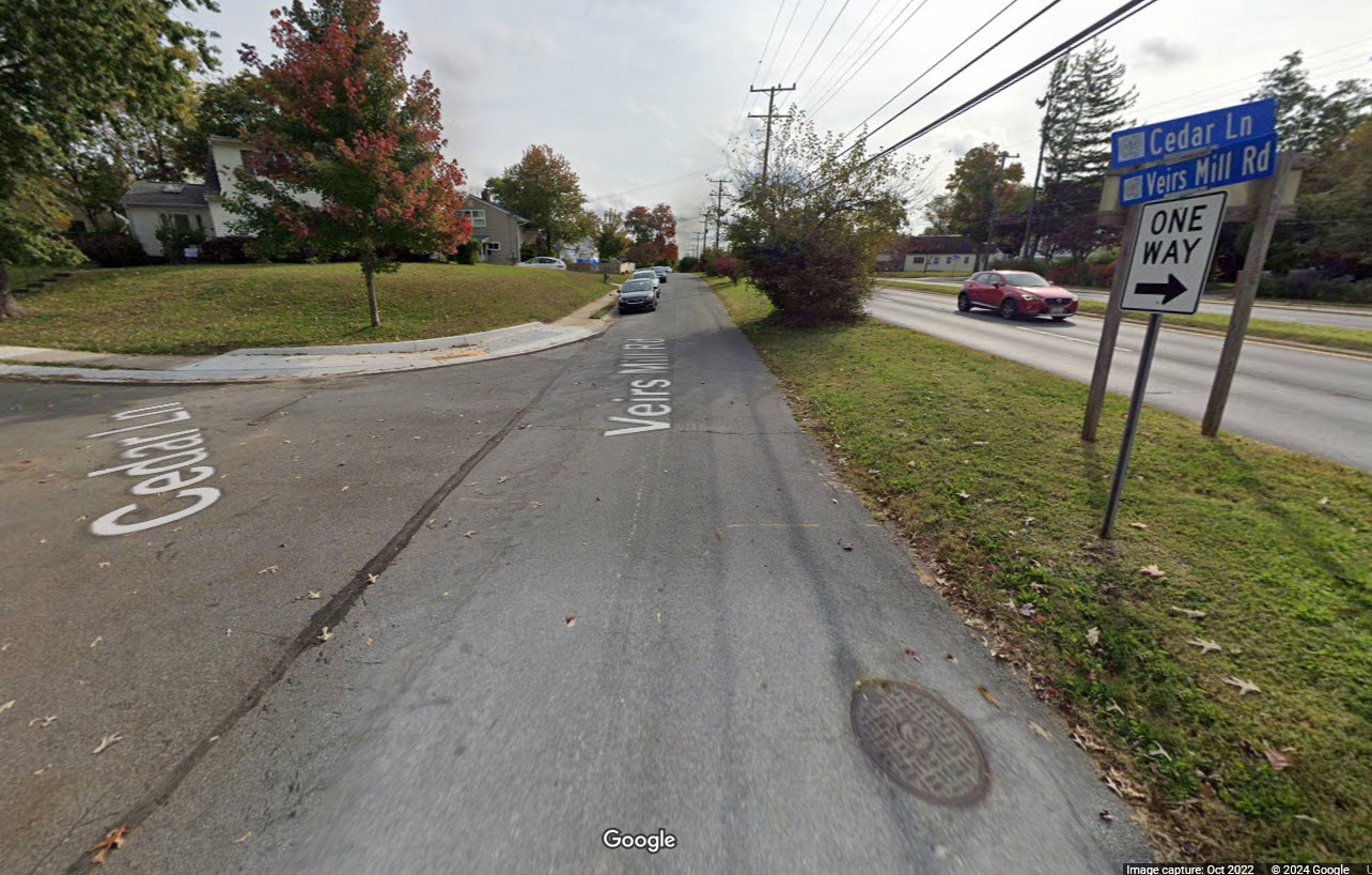
Today, Veirs Mill Road is a four-lane divided highway.

Veirs Mill Road at Cedar Lane showing deep ruts in the surface, 1911. The wagon wheels and tires of the time were very thin, and would sink straight into ruts, sometimes getting stuck. Photo by Lewis Reed.
From the “Times” (Washington):
Stalled in the mud… “Although he put on the entire 20-horsepower of his machine and called in assistance of several neighbors, it was not until shovels and crowbars had been procured to move his car… he was able to resume his journey. This experience not only caused more than an hour’s delay in reaching the city but the wear and tear on himself, those who rendered assistance, and incidentally, the machine. Thus, at least two months of the life of a $3,000 auto was spent in simply traversing a short stretch of roadway.”

A view down Cedar Lane in Bethesda, 1911. Photo by Lewis Reed.
Rockville Pike’s reputation as “one of the worst pieces of main highway in the state” eventually helped initiate Maryland’s Good Roads Movement, alongside a nationwide initiative to improve America’s roads. Responding to citizen demands, the newly created State Roads Commission incorporated the Rockville Pike into the state highway system.
In 1956, President Eisenhower passed legislation to implement (arguably) the greatest public-works project in U.S. history: the Interstate Highway System.
With this, every major city in America would be connected via highway construction, and mobility within the U.S. would ideally become limitless: a giant leap from the dirt roads and muddy paths that existed at the beginning of the century.
Find photos like these and much more on Montgomery History’s online exhibit, “Montgomery County 1900-1930: Through the Lens of Lewis Reed“.
Books
![]()
Related Resources


Copyright Notice

Reed Brothers Dodge History (1915-2012) by Jeanne Gartner is licensed under a Creative Commons Attribution-NonCommercial 3.0 Unported License.

Recent Comments