
Then & Now: Baltimore & Ohio Railroad, Point of Rocks Tunnel
This post is a continuation of a series of “Then & Now” images from Lewis Reed’s Photo Collection alongside photographs of how they appear today. Lewis Reed worked hard to preserve a visual history of Montgomery County, Maryland and surrounding area long before automobiles were even around. As early as 1905, he toured on his motorcycle across the states of Maryland, Virginia, and Washington, D.C. and took photographs of many historic locations. Taken over 112 years apart, you can see how the Point of Rocks Train Tunnel in Maryland looks almost the same from over a century ago.
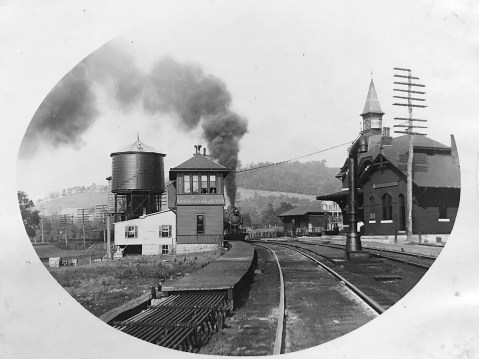
Point of Rocks Tunnel (THEN): Just west of the Point of Rocks Train Station is the Point of Rocks Tunnel. The original single-track main line is the track on the far left which goes around the cliff. A boxcar is visible just to the left of the tunnel opening. The tunnel was completed in 1902 when it became necessary to add a second track. The tunnel portal has a brick facade with the bricks forming the words, “Point of Rocks” above the opening. Just over the river bank from the original main line was the Chesapeake & Ohio Canal (C&O). Space is tight there and the railroad and canal folks were often at odds. A wall between the two was constructed to help ensure the trains did not scare the mules pulling the canal boats.

Point of Rocks Train Tunnel, 1911. Photo by Lewis Reed
Point of Rocks Tunnel (NOW): The tunnel was enlarged in 1902 to accommodate larger trains. In the early 1960s, the eastbound track was moved to the outside of the tunnel to accommodate still larger trains. This was done by blasting the rocks on the old alignment outside the tunnel, enlarging the road bed, and dumping the excavation rocks into the canal bed, where they remain today.

Point of Rocks Train Tunnel today
Point of Rocks Maryland, 1911

Point of Rocks, 1911. Photo by Lewis Reed
In 1835, the community of Point of Rocks, originally known as Trummelstown, was laid out at the foot of the Catoctin Mountains along the route of the C&O Canal and the B&O Railroad in order to provide dwellings for workers building the railroad and canal. The community was soon thereafter renamed for a nearby notable geographic feature of projecting rocks formed at the point where the Catoctin mountain range reached the Potomac River. This feature is no longer visible today, as it has been largely removed to accommodate the construction of the railroad and Point of Rocks Tunnel. The coming of the transportation routes and the construction of an adjacent bridge crossing and railroad spur over the Potomac River in 1852 lead to the growth of the town. By 1858, dwellings, a store, a hotel and a number of warehouses and flour mills that received grain from northern Virginia farmers for transport to Washington were located along the north side of the railroad.
Point of Rocks Railroad Station, 1911. Photo by Lewis Reed
The growth of the Point of Rocks area was further prompted by the erection of the largest iron forge in the tri-state area on the opposite bank of the Potomac in Loudoun County, Virginia. In the mid-19th century, the operation employed over 250 men, many of whom crossed over the bridge from Maryland. The town also served passenger traffic on the railroad and became one of a number of resort towns along the Potomac River. By 1873, warehouses, hotels, and other commercial building lined both sides of the railroad and canal in an area south of the present-day village. In 1873, a location about a mile to the southeast of Point of Rocks became the junction of the B&O Railroad’s Metropolitan Branch and the Old Main Line passenger trains. The station name was first Point of Rocks, then changed to Washington Station in 1876, and reverted back to Point of Rocks in 1923.
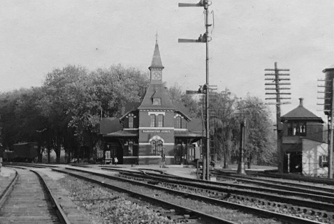
Point of Rocks Railroad Station, 1911. Photo by Lewis Reed
The growth of the low-lying village was inhibited throughout the 19th and 20th centuries by several floods. By 1910, few remnants of the original village remained, with most of the village now being located on higher ground. In 2009, the earliest extant buildings date to the late 19th century.
Veirs Mill Road Prior to Paving, 1911
Do you recognize the road pictured below? Few modern residents of Montgomery County would guess, but it is a shot of Veirs Mill Road before it was paved.

Veirs Mill Road looking east at Cedar Lane prior to paving, 1911. Photo by Lewis Reed.
Veirs Mill Road began in the 1700s as a prominent trading route leading from the mouth of the Monocacy River through Rockville to the tobacco port of Bladensburg. The road intersected with the Brookeville-Washington Turnpike (present-day Georgia Avenue), established in 1828. Veirs Mill Road was named for the saw and grist mill built in 1838 by Samuel Clark Veirs on Rock Creek, an important early waterway in the Washington, DC region.
In the early 19th century, most roads were dreadful. Rural roads were often little more than muddy trails. The popularity of the car coincided with the improvement of public roads around Rockville. By 1929, when Montgomery County residents owned 13,000 cars, the Rockville Pike and Montgomery Avenue had both been paved, but the less-traveled Veirs Mill Road remained a narrow dirt road for decades after that.
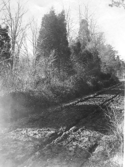
Veirs Mill Road at Cedar Lane showing deep ruts in the surface, 1911. The wagon wheels and tires of the time were very thin, and would sink straight into ruts, sometimes getting stuck. Photo by Lewis Reed.
From the “Times” (Washington):
Stalled in the mud… “Although he put on the entire 20-horsepower of his machine and called in assistance of several neighbors, it was not until shovels and crowbars had been procured to move his car… he was able to resume his journey. This experience not only caused more than an hour’s delay in reaching the city but the wear and tear on himself, those who rendered assistance, and incidentally, the machine. Thus, at least two months of the life of a $3,000 auto was spent in simply traversing a short stretch of roadway.”
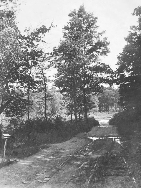
A view down Cedar Lane in Bethesda, 1911. Photo by Lewis Reed.
Rockville Pike’s reputation as “one of the worst pieces of main highway in the state” eventually helped initiate Maryland’s Good Roads Movement, alongside a nationwide initiative to improve America’s roads. Responding to citizen demands, the newly created State Roads Commission incorporated the Rockville Pike into the state highway system.
In 1956, President Eisenhower passed legislation to implement (arguably) the greatest public-works project in U.S. history: the Interstate Highway System.
With this, every major city in America would be connected via highway construction, and mobility within the U.S. would ideally become limitless: a giant leap from the dirt roads and muddy paths that existed at the beginning of the century.
Find photos like these and much more on Montgomery History’s online exhibit, “Montgomery County 1900-1930: Through the Lens of Lewis Reed“.
Then & Now: 1st National Bank of Monrovia
This post is a continuation of a series of “Then & Now” images from Lewis Reed’s Photo Collection alongside photographs of how they appear today. Lewis Reed worked hard to preserve a visual history of Montgomery County, Maryland and surrounding area long before automobiles were even around. As early as 1905, he toured on his motorcycle across the states of Maryland, Virginia, and Washington, D.C. and took photographs of many historic locations. Taken approximately 113 years apart, you can see how the 1st National Bank of Monrovia Maryland looks almost the same from over a century ago.
1st National Bank of Monrovia (THEN): In 1908, the First National Bank of Monrovia was founded and the Renaissance Revival bank building was erected. The bank was merged with the Central Trust Company in 1916 and closed in the early 1930’s in the aftermath of the 1929 stock market crash and ensuing Great Depression of the 1930’s.

1st National Bank of Monrovia. Photo by Lewis Reed, 1910
1st National Bank of Monrovia (NOW): The bank is now the office of a construction company.
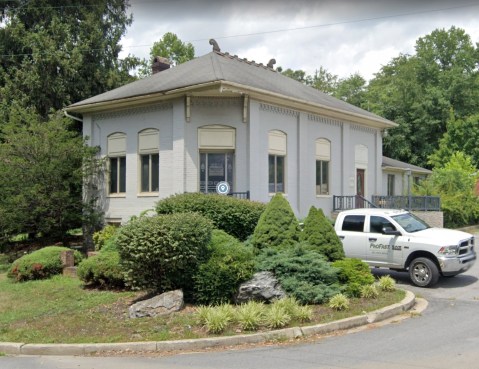
The 1st National Bank of Monrovia today is still very recognizable
Source: Monrovia, Maryland – Wikipedia
May 2, 1929: Montgomery County’s Deadliest Tornado (Aftermath Photos)
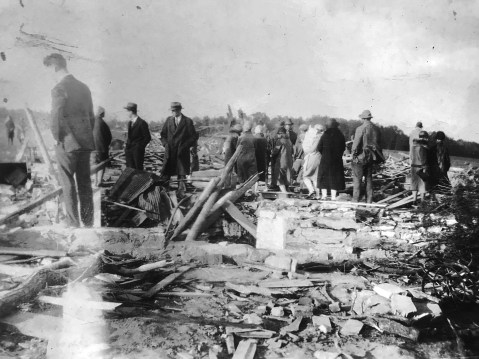
Spectators view the destruction at the Benson farm, May 1929. Photo by Lewis Reed
Ninety-four years ago today, one of the worst tornado outbreaks in area history devastated a part of Montgomery County Maryland. At about 9 p.m. on Thursday, May 2, 1929, northeastern Montgomery County was struck by an F3 tornado, part of a large storm system that caused devastation from Florida to Ohio. The weekly Montgomery County Sentinel reported on May 10th that the “wind storm of cyclonic power . . . was of limited width and serpentine on its course. Everything in its path met with destruction.” These photographs were taken by Lewis Reed “after the tornado of May 2, 1929”.

May 1929. Photo by Lewis Reed
The damage in the county was limited to the rural Unity area, north of Brookeville. The Sentinel article detailed each affected farm, noting that “thousands of persons from far and near visited the scene for several days to look upon the indescribable wreckage.”

May 1929. Photo by Lewis Reed
From the Sentinel: “The storm showed its first violence upon the farm of Mr. J. William Benson. There it destroyed every building – the dwelling house, large barn, 117 feet long, including an attached shed, and all other outbuildings.” The farm was unoccupied, but furniture belonging to “a prospective tenant” was destroyed. Mr. Benson’s apple orchard was also significantly damaged, and the article claimed that “many [trees] were lifted into the air, carried over woods and landed several miles away.”
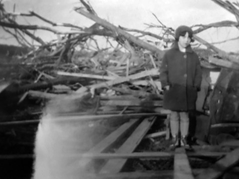
Lewis Reed’s daughter, Mary Jane, May 1929. Photo by Lewis Reed
The fire departments of Rockville, Gaithersburg and Sandy Spring responded to the call made by farm worker James Leizear, who “extricated himself from the wreckage” and ran half a mile to a neighbor’s house to summon help.
The Post reported on May 4th that 28 people in Maryland and Virginia had been killed by tornadoes during the storm; most of the casualties were in Virginia, where an elementary school was struck full-force and at least 18 children died. In Montgomery County, the local Red Cross Chapter formed a citizen committee to raise funds “for relief of the sufferers.”

May 1929. Photo by Lewis Reed
Note: These photographs were undated and unlabeled in my grandfather’s collection. My mother, Mary Jane (Reed) Gartner, who is seen above when she was almost 7 years old, positively identified these photographs and just about pinpointed the location! It’s amazing the things you remember from your early childhood.
Sources of Information:
A Fine Collection
The Montgomery County Sentinel, May 10, 1929
Books
![]()
Related Resources


Copyright Notice

Reed Brothers Dodge History (1915-2012) by Jeanne Gartner is licensed under a Creative Commons Attribution-NonCommercial 3.0 Unported License.

Recent Comments